Museums · East of England
Manningtree
In or near Mistley.
Manningtree is a town and civil parish in the Tendring district of Essex, England. It lies on the River Stour and forms part of the Suffolk Coast and Heaths Area of Outstanding Natural Beauty. At the

Jim Osley — CC BY-SA 2.0 via Wikimedia Commons licence
Plan your visit
- Typical visit
- 1.5 h–3 h
- Best time of year
- Year-round
- Nearest railway station
- Manningtree · 1.3 km
- Family-friendly
- Limited wheelchair access
About
Manningtree is a town and civil parish in the Tendring district of Essex, England. It lies on the River Stour and forms part of the Suffolk Coast and Heaths Area of Outstanding Natural Beauty. At the 2021 census the parish had a population of 874 and the built up area (which extends into the neighbouring parishes of Lawford and Mistley) had a population of 1,761.
Photo gallery
Official information
The Manifest Theatre is an award-winning venue that hosts a variety of theatrical performances. Visitors can enjoy a range of shows throughout the year, including classic plays and musicals.
Protected designations
- Site of Special Scientific Interest: Stour Estuary SSSI
- Area of Outstanding Natural Beauty: Suffolk Coast & Heaths
- Ramsar wetland: Stour and Orwell Estuaries
Designations sourced from Natural England open data under OGL v3.
From the Wikipedia article
Manningtree is a town and civil parish in the Tendring district of Essex, England. It lies on the River Stour and forms part of the Suffolk Coast and Heaths Area of Outstanding Natural Beauty. At the 2021 census the parish had a population of 874 and the built up area (which extends into the neighbouring parishes of Lawford and Mistley) had a population of 1,761.
Excerpt from Wikipedia under CC BY-SA 4.0. See the source article linked in Sources below.
Background
History
]] The name Manningtree is thought to derive from 'many trees'. The town grew around the wool trade from the 15th century until its decline in the 18th century and also had a thriving shipping trade in corn, timber and coal until this declined with the coming of the railway. The Ascension, by John Constable, which now hangs in Dedham church, was commissioned in 1821 for the altarpiece of the early seventeenth-century church on the High Street, demolished in 1967.
Sourced from Wikipedia under CC BY-SA 4.0.
- Coordinates
- 51.9443, 1.0614
- County
- Essex
- District
- Tendring
- Parish
- Manningtree
- Postcode
- CO11 1DU
- Parliamentary constituency
- Harwich and North Essex
- Nearest railway station
- Manningtree — 1.3 km
- Official site
- www.manifesttheatre.co.uk
Sources
- wikipedia: Manningtree (CC BY-SA 4.0)
Other places nearby

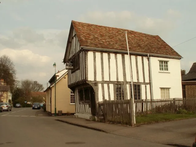
Manningtree Museum
Museums · 0.2 km

Manifest Theatre
Theatres · 0.3 km

War Memorial
Memorials & monuments · 0.3 km

Folly Bridge Approximately 35 Metres South East Of Mistley Hall
Historic bridges · 0.9 km

Mistley and Manningtree Cemetery
Cemeteries · 0.9 km

South Face Of Hopping Bridge
Historic bridges · 0.9 km

Lawford Village Sign
Public art & sculpture · 1.0 km

Mistley Towers, North West Tower
Memorials & monuments · 1.1 km
Mistley Village Sign
Public art & sculpture · 1.1 km
Mistley Towers, South East Tower
Historic houses · 1.1 km
Mistley Towers
Historic houses · 1.1 km

Mistley Quay Wall (Also Known As Thorn Or Allen's Quay)
Marinas · 1.3 km
Nearby
📷 3Museums · East of England
Manningtree Museum
Manningtree Museum — a museum in england-east, United Kingdom.
📷 3Theatres · East of England
Manifest Theatre
Manifest Theatre is a theatre in the United Kingdom.
📷 5Memorials & monuments · East of England
War Memorial
War Memorial is a memorial in the United Kingdom.
📷 3Historic bridges · East of England
Folly Bridge Approximately 35 Metres South East Of Mistley Hall
Folly Bridge Approximately 35 Metres South East Of Mistley Hall — Grade II listed building-listed bridge in england-east, United Kingdom.
📷 3Cemeteries · East of England
Mistley and Manningtree Cemetery
Mistley and Manningtree Cemetery is a cemetery in the United Kingdom.
📷 3Historic bridges · East of England
South Face Of Hopping Bridge
South Face Of Hopping Bridge — Grade II listed building-listed bridge in england-east, United Kingdom.
Where to eat & stay near Manningtree
Places to stay
 📷 5
📷 5Caravan parks · East of England
The Grange Country Park
The Grange Country Park — a caravan park in england east.
 📷 5
📷 5Campsites · East of England
Strangers Holiday Park
Strangers Holiday Park — a campsite in england east.
 📷 5
📷 5 📷 5
📷 5 📷 5
📷 5 📷 5
📷 5Campsites · East of England
Alton Water Campsite
Alton Water Campsite — a campsite in england east.
Places to eat & drink
 📷 7
📷 7 📷 7
📷 7Historic pubs · East of England
The Red Lion, East Bergholt
The Red Lion, East Bergholt in England East, United Kingdom.
 📷 5
📷 5Historic pubs · East of England
Loom House Marlborough Head Inn
Loom House Marlborough Head Inn in England East, United Kingdom.
 📷 7
📷 7Historic pubs · East of England
The Lion Inn, Ardleigh
The Lion Inn, Ardleigh in England East, United Kingdom.
📷 5Restaurants · East of England
The Lion Of Bengal
The Lion Of Bengal — a restaurant in england east.
 📷 5
📷 5Historic pubs · East of England
The Welcome Sailor Public House
The Welcome Sailor Public House in England East, United Kingdom.
More museums in this region
 📷 5
📷 5Museums · East of England
American Air Museum
American Air Museum — museum at Imperial War Museum Duxford, Cambridgeshire, England, UK.
 📷 5
📷 5Museums · East of England
Ashwell Village Museum
Ashwell Village Museum — historic building museum in Ashwell, Hertfordshire, England, United Kingdom.
 📷 5
📷 5Museums · East of England
Barleylands Farm Museum
Barleylands Farm Museum — Farm museum in Billericay, England.
 📷 5
📷 5Museums · East of England
Cromwell Museum
Cromwell Museum — museum in Huntingdon, England, United Kingdom.
Frequently asked questions
- Where is Manningtree?
- Manningtree is in Essex, East of England, United Kingdom (postcode CO11 1DU), in the parish of Manningtree.
- What is Manningtree?
- Manningtree is a town and civil parish in the Tendring district of Essex, England. It lies on the River Stour and forms part of the Suffolk Coast and Heaths Area of Outstanding Natural Beauty. At the
- How do I get to Manningtree?
- The nearest railway station is Manningtree, about 1.3 km away. Drivers can use postcode CO11 1DU.
- Is Manningtree a protected site?
- Yes — Manningtree is part of the Stour Estuary SSSI Site of Special Scientific Interest and the Suffolk Coast & Heaths National Landscape (AONB).
- How do I get to Manningtree?
- The nearest railway station is Manningtree, about 1.3 km away. Drivers can navigate to postcode CO11 1DU.