
Mountains & hills · Central Scotland
Machir Bay
In or near Bruichladdich.
Machir Bay — bay in Argyll and Bute, Scotland, UK.

Wikimedia Commons contributors — see linked file page for photographer and licence licence

Plan your visit
- Typical visit
- 3 h–8 h
- Best time of year
- Late spring – early autumn (May–Oct)
- Free entry
- Dog-friendly
About
Machir Bay is a named summit in the United Kingdom. Wikidata describes it as: "bay in Argyll and Bute, Scotland, UK". Coordinates: 55.7778°, -6.4694°.
Photo gallery
From the Wikipedia article
Machir Bay is a small bay on the Western coast of the isle of Islay in the Inner Hebrides of Scotland. It is one of the features of the Rhinns of Islay and lies within a few hundred metres of the small settlement of Kilchoman. To the north, the cape of Coul Point separates Machir Bay from Saligo Bay. Kilchiaran Bay lies immediately to the south. The northern and southern parts of Machir Bay are largely rocky, with a sandy beach area near the top of the bay. Several small streams flow into the bay, notably Allt na Criche and Allt Gleann na Ceardaich, both of which flow into the north of the bay.
Excerpt from Wikipedia under CC BY-SA 4.0. See the source article linked in Sources below.
- Coordinates
- 55.7778, -6.4694
- District
- Argyll and Bute
- Postcode
- PA49 7UX
- Parliamentary constituency
- Argyll, Bute and South Lochaber
Sources
- wikidata: Q1882686 (CC0)
- wikipedia: Machir Bay (CC BY-SA 4.0)
- commons: Machir Bay From The North - geograph.org.uk - 700233.jpg (CC BY-SA 4.0)
Other places nearby

Machir Bay
Natural landmarks · 0.6 km

Traigh Machair
Beaches · 0.7 km

Tràigh Machir, dun site
Archaeological sites · 1.1 km

Dun Chroisprig
Archaeological sites · 1.4 km
CWGC Cross of Sacrifice
Memorials & monuments · 1.4 km

Kilchoman Cross-slab
Memorials & monuments · 1.5 km
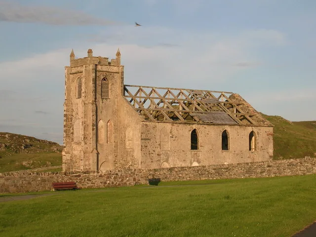
Kilchoman Old Parish Church
Historic churches · 1.8 km

Kilchoman Cross
Memorials & monuments · 1.8 km

Old Kilchoman Parish Church
Archaeological sites · 1.8 km

Kilchoman House
Historic houses · 1.8 km

Creag Mhor
Mountains & hills · 2.2 km

Islay, Am Burg, Coul
Vineyards · 2.2 km
Nearby
📷 5Natural landmarks · Central Scotland
Machir Bay
Machir Bay — a natural feature in scotland highlands.
📷 3📷 3Archaeological sites · Central Scotland
Tràigh Machir, dun site
Tràigh Machir, dun site — a archaeological in scotland-highlands, United Kingdom.
📷 3Archaeological sites · Central Scotland
Dun Chroisprig
Dun Chroisprig — a archaeological in scotland-highlands, United Kingdom.
Memorials & monuments · Central Scotland
CWGC Cross of Sacrifice
CWGC Cross of Sacrifice — a memorial in scotland central.
📷 3Memorials & monuments · Central Scotland
Kilchoman Cross-slab
Kilchoman Cross-slab — a memorial in scotland-highlands, United Kingdom.
Where to eat & stay near Machir Bay
Places to stay
 📷 5
📷 5Hostels · Scottish Lowlands
Port Charlotte Youth Hostel
Port Charlotte Youth Hostel — a hostel in scotland highlands.
 📷 5
📷 5Campsites · Scottish Lowlands
Port Mòr Campsite
Port Mòr Campsite — a campsite in scotland highlands.
 📷 5
📷 5 📷 5
📷 5 📷 5
📷 5Hotels · Central Scotland
Bridgend Hotel
Bridgend Hotel — a hotel in scotland highlands.
 📷 3
📷 3More mountains in this region
 📷 3
📷 3 📷 3
📷 3 📷 3
📷 3Mountains & hills · Central Scotland
An Caisteal
An Caisteal — Named summit at 995 m.
 📷 5
📷 5Frequently asked questions
- Where is Machir Bay?
- Machir Bay is in central Scotland, United Kingdom (postcode PA49 7UX).
- What is Machir Bay?
- Machir Bay — bay in Argyll and Bute, Scotland, UK.
- How do I get to Machir Bay?
- The nearest town is Bruichladdich. Drivers can use postcode PA49 7UX.
- Is Machir Bay free to visit?
- Yes, Machir Bay is free to enter.
- How do I get to Machir Bay?
- Drivers can navigate to postcode PA49 7UX. It sits within the Argyll, Bute and South Lochaber parliamentary constituency.