Mountains & hills · North West England
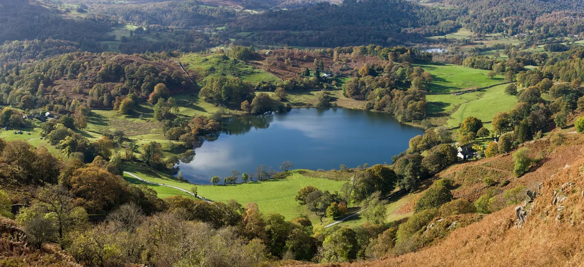
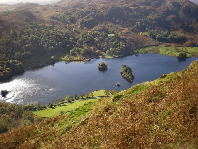
Loughrigg Fell
In or near Rydal.
Loughrigg Fell — Named summit at 335.1 m.

Wikimedia Commons contributors — see linked file page for photographer and licence licence
Plan your visit
- Typical visit
- 3 h–8 h
- Best time of year
- Late spring – early autumn (May–Oct)
- Nearest railway station
- Windermere · 9.4 km
- Free entry
- Dog-friendly
About
Loughrigg Fell is a named summit in the United Kingdom. Wikidata describes it as: "Named summit at 335.1 m.". Coordinates: 54.4375°, -3.0084°.
Photo gallery
Protected designations
- Site of Special Scientific Interest: River Eden and Tributaries SSSI
Designations sourced from Natural England open data under OGL v3.
From the Wikipedia article
Loughrigg Fell is a hill in the central part of the English Lake District. It stands on the end of the long ridge coming down from High Raise over Silver How towards Ambleside, and is separated from its neighbours by the depression of Red Bank.
Excerpt from Wikipedia under CC BY-SA 4.0. See the source article linked in Sources below.
- Coordinates
- 54.4375, -3.0084
- District
- Westmorland and Furness
- Parish
- Lakes
- Postcode
- LA22 9HQ
- Parliamentary constituency
- Westmorland and Lonsdale
- Nearest railway station
- Windermere — 9.4 km
Sources
- osm: n1779620834 (ODbL)
- wikipedia: Loughrigg Fell (CC BY-SA 4.0)
- commons: LoughriggSummit.jpg (CC BY-SA 4.0)
Other places nearby

Todd Crag
Mountains & hills · 0.0 km
Loughrigg Tarn
Natural landmarks · 0.8 km

YHA Langdale
Hostels · 0.9 km

Rydal Cave
Caves · 1.0 km

Tarn Foot Farm Campsite
Campsites · 1.0 km

Fox How
Mountains & hills · 1.2 km

Lanty Scar
Mountains & hills · 1.2 km

Little Loughrigg
Mountains & hills · 1.2 km
Little Loughrigg
Mountains & hills · 1.2 km
Rydal Water
Natural landmarks · 1.4 km

Todd Crag
Mountains & hills · 1.5 km

White Moss House
Historic houses · 1.5 km
Nearby
📷 3Mountains & hills · North West England
Todd Crag
Todd Crag — a mountain in england-north-west, United Kingdom, 224 m.
📷 3Natural landmarks · North West England
Loughrigg Tarn
Loughrigg Tarn — lake in the Lake District, Cumbria, England.
📷 5Hostels · North West England
YHA Langdale
YHA Langdale — a hostel in england north west. Brand: Youth Hostels Association.
📷 3Caves · North West England
Rydal Cave
Rydal Cave — a cave in england-north-west, United Kingdom.
📷 5Campsites · North West England
Tarn Foot Farm Campsite
Tarn Foot Farm Campsite — a campsite in england north west.
📷 5Mountains & hills · North West England
Fox How
Fox How — mountain in england north west. Elevation: 246 m.
Where to eat & stay near Loughrigg Fell
Places to stay
📷 5Hostels · North West England
YHA Langdale
YHA Langdale — a hostel in england north west. Brand: Youth Hostels Association.
📷 5Campsites · North West England
Tarn Foot Farm Campsite
Tarn Foot Farm Campsite — a campsite in england north west.
 📷 6
📷 6Hotels · North West England
Glen Rothay Hotel
Glen Rothay Hotel — a hotel in england north west.
 📷 5
📷 5Hostels · North West England
Elterwater Hostel
Elterwater Hostel — a hostel in england north west.
 📷 5
📷 5 📷 6
📷 6Places to eat & drink
 📷 5
📷 5Historic pubs · North West England
Golden Rule Hotel
Golden Rule Hotel in England North West, United Kingdom.
 📷 7
📷 7Historic pubs · North West England
The Travellers Rest
The Travellers Rest in England North West, United Kingdom.
 📷 5
📷 5Restaurants · North West England
Holbeck Ghyll Restaurant
Holbeck Ghyll Restaurant — a restaurant in england north west.
 📷 4
📷 4Restaurants · North West England
Holbeck Ghyll
Holbeck Ghyll is a restaurant located in Windermere, Cumbria, England. "The late 19th century building was once Lord Lonsdale's hunting lodge and only became a hotel in the 1970s. It won a Michelin st
📷 5Historic pubs · North West England
Holbeck Ghyll
Holbeck Ghyll in England North West, United Kingdom.
 📷 5
📷 5Historic pubs · North West England
Sun Cottage Sun Inn Public House
Sun Cottage Sun Inn Public House in England North West, United Kingdom.
More mountains in this region
 📷 5
📷 5Mountains & hills · North West England
Appleton Park
Appleton Park — a hill or mountain in england west midlands.
 📷 5
📷 5Mountains & hills · North West England
High Warren
High Warren — mountain in england west midlands. Elevation: 105 m.
 📷 5
📷 5Mountains & hills · North West England
Alderley Edge
Alderley Edge — mountain in england west midlands. Elevation: 194 m.
 📷 3
📷 3Frequently asked questions
- Where is Loughrigg Fell?
- Loughrigg Fell is in North-West England, United Kingdom (postcode LA22 9HQ), in the parish of Lakes.
- What is Loughrigg Fell?
- Loughrigg Fell — Named summit at 335.1 m.
- How do I get to Loughrigg Fell?
- The nearest railway station is Windermere, about 9.4 km away. Drivers can use postcode LA22 9HQ.
- Is Loughrigg Fell a protected site?
- Yes — Loughrigg Fell is part of the River Eden and Tributaries SSSI Site of Special Scientific Interest.
- Is Loughrigg Fell free to visit?
- Yes, Loughrigg Fell is free to enter.
- How do I get to Loughrigg Fell?
- Drivers can navigate to postcode LA22 9HQ. It sits within the Westmorland and Lonsdale parliamentary constituency.