
Mountains & hills · North West England
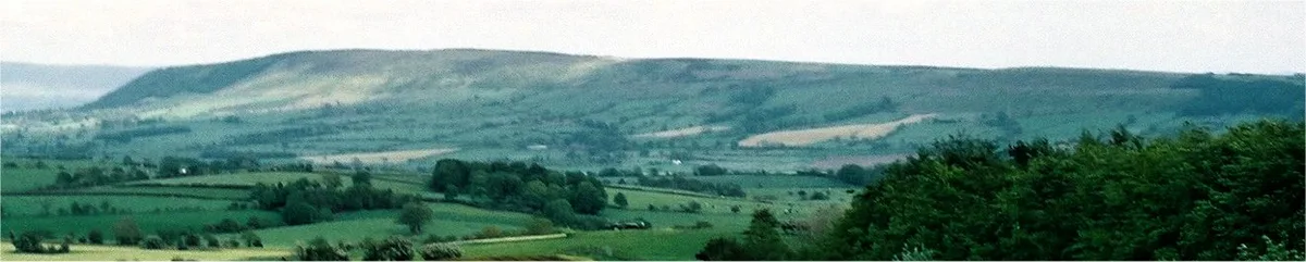
Longridge Fell
In or near Bashall Eaves.
Longridge Fell — Named summit at 350.2 m.

Wikimedia Commons contributors — see linked file page for photographer and licence licence

Plan your visit
- Typical visit
- 3 h–8 h
- Best time of year
- Late spring – early autumn (May–Oct)
- Nearest railway station
- Langho · 8.2 km
- Free entry
- Dog-friendly
Getting there & planning your visit
To visit Longridge Fell, the nearest railway station is Langho, located 8.2 km away. Entry is free, and the postcode for sat-nav is BB7 3LY.
About
Longridge Fell is a named summit in the United Kingdom. Wikidata describes it as: "Named summit at 350.2 m.". Coordinates: 53.8646°, -2.5216°.
Photo gallery
Protected designations
- Area of Outstanding Natural Beauty: Forest Of Bowland
Designations sourced from Natural England open data under OGL v3.
From the Wikipedia article
Longridge Fell is the most southerly fell in England, near the town of Longridge, Lancashire. It lies at the southern end of the Forest of Bowland Area of Outstanding Natural Beauty. As its name suggests, it takes the form of a long ridge which rises in a north-easterly direction from within the town of Longridge to its summit 4.5 miles distant. As the ridge curves towards the east, it comes to a sudden end and drops into the Hodder Valley. The fell is an example of a cuesta; the ridge has a sharp drop or escarpment on its northern side, and a gentler, more varying slope on its southern side. These features make it a popular takeoff for hang-gliders and paragliders on the relatively infrequent occurrences of a northerly wind. From the fell's 1,148-ft (350-m) summit, views are afforded of Preston to the south-west; the Fylde Coast to the west; the Vale of Chipping and the fells of the Forest of Bowland to the north and west (including Parlick, Fair Snape Fell and Beacon Fell); the Yorkshire Dales to the north-east (including, most notably, Pen-y-ghent); Clitheroe, Pendle Hill and Whalley, to the east and south-east; and Winter Hill and the West Pennine Moors and the BAE Systems factory at Samlesbury Aerodrome. On clear days, the Lake District and sometimes the Isle of Man can be seen to the north-west, and the Snowdonia mountain range to the south-west. The River Hodder and its tributary, the River Loud, flow eastward along the north side of the fell, before turning south at the end of the fell to join the River Ribble, which runs westward along the south of the fell. Cowley Brook, a tributary of Stydd Brook, begins its course near the fell. The village of Hurst Green and the adjoining Stonyhurst College lie on the south side of the fell. Longridge town lies at the south-west end of the fell. There were once extensive stone quarries at Tootle Heights, now mostly built on apart from a deep rocky water-filled remnant off the Tan Yard bridlepath, and the reservoirs.…
Excerpt from Wikipedia under CC BY-SA 4.0. See the source article linked in Sources below.
- Coordinates
- 53.8646, -2.5216
- County
- Lancashire
- District
- Ribble Valley
- Parish
- Aighton, Bailey and Chaigley
- Postcode
- BB7 3LY
- Parliamentary constituency
- Ribble Valley
- Nearest railway station
- Langho — 8.2 km
Sources
- osm: n434346494 (ODbL)
- wikipedia: Longridge Fell (CC BY-SA 4.0)
- commons: Longridge Fell 229-03.jpg (CC BY-SA 4.0)
Featured in this guide
Other places nearby
Longridge Fell
Natural landmarks · 0.2 km

Loud Mytham Bridge
Historic bridges · 2.2 km

Huntingdon Hall
Historic houses · 2.2 km

Dutton Manor
Manor houses · 2.5 km

Stakes
Historic houses · 2.9 km

Lady Statue
Public art & sculpture · 3.6 km

Chaigley Manor
Manor houses · 3.7 km

Stonyhurst College
Historic houses · 3.8 km

Centeneries Theatre
Theatres · 3.9 km

Higher Hodder Bridge
Historic bridges · 3.9 km

Chipping Showground
Natural landmarks · 3.9 km

Stonyhurst Saint Mary's Hall
Historic houses · 4.0 km
Nearby
📷 5Natural landmarks · North West England
Longridge Fell
Longridge Fell — mountain in United Kingdom.
📷 3Historic bridges · North West England
Loud Mytham Bridge
Loud Mytham Bridge — Grade II listed building-listed bridge in england-north-west, United Kingdom.
📷 3Historic houses · North West England
Huntingdon Hall
Huntingdon Hall — house in Dutton, Ribble Valley, England, UK.
📷 3Manor houses · North West England
Dutton Manor
Dutton Manor — Grade II listed building-listed manor in england-north-west, United Kingdom.
📷 3Historic houses · North West England
Stakes
Stakes — Grade II* listed house in the parish of Bowland Forest Low, Ribble Valley, England, UK.
📷 3Public art & sculpture · North West England
Lady Statue
Lady Statue — a public art in england-north-west, United Kingdom.
Where to eat & stay near Longridge Fell
Places to stay
 📷 5
📷 5Caravan parks · North West England
Brickhouse Caravan Site
Brickhouse Caravan Site — a caravan park in england north west.
 📷 5
📷 5Hostels · North West England
Clark House Camping Barn
Clark House Camping Barn — a hostel in england north west.
 📷 5
📷 5Caravan parks · North West England
Beacon Fell View Holiday Village
Beacon Fell View Holiday Village — a caravan park in england north west.
 📷 5
📷 5 📷 5
📷 5Campsites · North West England
Wigwam Holidays Ribble Valley
Wigwam Holidays Ribble Valley — a campsite in england north west.
 📷 5
📷 5Campsites · North West England
Edisford Bridge Farm Camping & Caravan Site
Edisford Bridge Farm Camping & Caravan Site — a campsite in england north west.
Places to eat & drink
 📷 5
📷 5Restaurants · North West England
The Inn at Whitewell
The Inn at Whitewell — a restaurant in england north west.
 📷 5
📷 5Restaurants · North West England
The Three Fishes
The Three Fishes — a restaurant in england north west.
 📷 5
📷 5Historic pubs · North West England
Ye Horns Inn
Ye Horns Inn in England North West, United Kingdom.
 📷 5
📷 5Historic pubs · North West England
Swan with Two Necks
Swan with Two Necks in England North West, United Kingdom.
 📷 5
📷 5Restaurants · North West England
The Spread Eagle
The Spread Eagle — a restaurant in england north west.
 📷 5
📷 5More mountains in this region
 📷 5
📷 5Mountains & hills · North West England
Appleton Park
Appleton Park — a hill or mountain in england west midlands.
 📷 5
📷 5Mountains & hills · North West England
High Warren
High Warren — mountain in england west midlands. Elevation: 105 m.
 📷 5
📷 5Mountains & hills · North West England
Alderley Edge
Alderley Edge — mountain in england west midlands. Elevation: 194 m.
 📷 3
📷 3Frequently asked questions
- Where is Longridge Fell?
- Longridge Fell is in Lancashire, North-West England, United Kingdom (postcode BB7 3LY), in the parish of Aighton, Bailey and Chaigley.
- What is Longridge Fell?
- Longridge Fell — Named summit at 350.2 m.
- How do I get to Longridge Fell?
- The nearest railway station is Langho, about 8.2 km away. Drivers can use postcode BB7 3LY.
- Is Longridge Fell a protected site?
- Yes — Longridge Fell is part of the Forest Of Bowland National Landscape (AONB).
- Is Longridge Fell free to visit?
- Yes, Longridge Fell is free to enter.
- How do I get to Longridge Fell?
- Drivers can navigate to postcode BB7 3LY. It sits within the Ribble Valley parliamentary constituency.