Forests & woodlands · London
Long Lane Pasture
Long Lane Pasture is a forest or woodland in the United Kingdom.

Wikimedia Commons contributors — see linked file page for photographer and licence licence
Plan your visit
- Typical visit
- 1 h–3 h
- Nearest railway station
- Finchley Central · 0.9 km
- Free entry
- Family-friendly
- Dog-friendly
About
Long Lane Pasture is a named forest, woodland or nature reserve in the United Kingdom. Coordinates: 51.5970°, -0.1812°. This entry is part of The Great Britain Guide, a free, ad-free, open-data tourist directory.
Photo gallery
From the Wikipedia article
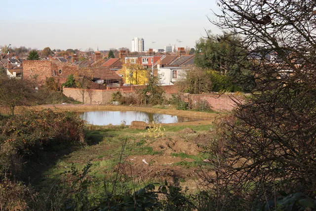
Long Lane Pasture is a 1.1-hectare (2.7-acre) nature reserve in Finchley in the London Borough of Barnet. It is owned by Barnet Council and managed by the Long Lane Pasture Trust. The council does not contribute any funds to the Trust. The site was acquired in 1912 by the Municipal Borough of Finchley for "public recreation and enjoyment", but it lost half its land to the construction of the North Circular Road in the 1920s. In 1965 Finchley borough became part of the London Borough of Barnet, which thus acquired the site. It was open to the public and for many years horses grazed on it, until the 1980s when it was closed for roadworks. In 1999 the council decided to sell it for housing, but the decision was overturned in 2006 following a public campaign to keep it as open space, and in 2009 the Trust was granted a 25-year lease. Under a management plan agreed with the council, the site is managed to protect its wildlife value and maintain and enhance its biodiversity. There is access by a footpath from Long Lane immediately north of the North Circular Road.
Excerpt from Wikipedia under CC BY-SA 4.0. See the source article linked in Sources below.
- Coordinates
- 51.5970, -0.1812
- District
- Barnet
- Parish
- Barnet, unparished area
- Postcode
- N3 2RU
- Parliamentary constituency
- Finchley and Golders Green
- Nearest railway station
- Finchley Central — 0.9 km
Sources
- osm: w1058131504 (ODbL)
- wikipedia: Long Lane Pasture (CC BY-SA 4.0)
- commons: Long Lane Pasture - geograph.org.uk - 614625.jpg (CC BY-SA 4.0)
Other places nearby
Loading nearby places…
Nearby
 📷 5
📷 5Wildlife reserves · London
Long Lane Pasture
Long Lane Pasture — nature preserve in Finchley, Barnet, Greater London, United Kingdom.
 📷 5
📷 5Wildlife reserves · London
Lakeside Nature Reserve
Lakeside Nature Reserve is a wildlife reserve in the United Kingdom.
 📷 5
📷 5Chapels · London
Finchley
Finchley — a methodist chapel in england-london, United Kingdom.
 📷 5
📷 5Memorials & monuments · London
Monument To Thomas Tate, St Marylebone Cemetery
Monument To Thomas Tate, St Marylebone Cemetery — Grade II listed building-listed memorial in england-london, United Kingdom.
 📷 5
📷 5Memorials & monuments · London
Sir Peter Nicol Russell Memorial
Sir Peter Nicol Russell Memorial — a memorial in england-london, United Kingdom.
 📷 5
📷 5Public art & sculpture · London
Monument To Sir Peter Nicol Russell Engineer In St Marylebone Cemetery
Monument To Sir Peter Nicol Russell Engineer In St Marylebone Cemetery in England London, United Kingdom.
More forests in this region
 📷 5
📷 5Forests & woodlands · London
Ackroyd Drive Green Link
Ackroyd Drive Green Link is a forest or woodland in the United Kingdom.
 📷 5
📷 5Forests & woodlands · London
Adams Road Bird Sanctuary
Adams Road Bird Sanctuary is a forest or woodland in the United Kingdom.
 📷 5
📷 5Forests & woodlands · London
Adelaide Nature Reserve
Adelaide Nature Reserve is a forest or woodland in the United Kingdom.
 📷 5
📷 5Forests & woodlands · London
Angel's Wings
Angel's Wings — Public artwork by Thomas Heatherwick.
Frequently asked questions
- Where is Long Lane Pasture?
- Long Lane Pasture is in London, United Kingdom (postcode N3 2RU), in the parish of Barnet, unparished area.
- Is Long Lane Pasture free to visit?
- Yes, Long Lane Pasture is free to enter.
- How do I get to Long Lane Pasture?
- The nearest railway station is Finchley Central, about 0.9 km away. Drivers can navigate to postcode N3 2RU.