National parks · Central Scotland
Lochearnhead
Also known as: Ceann Loch Éireann, Ceann Loch Èire
In or near Killin.
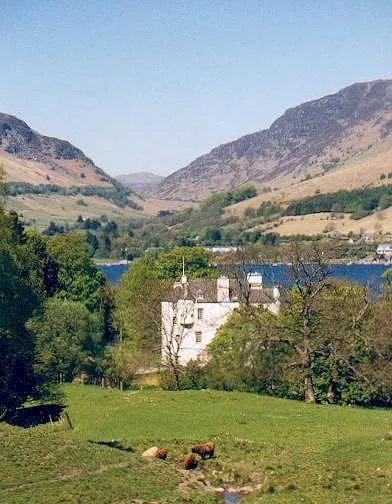
Lochearnhead in Scotland Islands, United Kingdom.

Colin Smith — CC BY-SA 2.0 via Wikimedia Commons licence
Plan your visit
- Typical visit
- 4 h–8 h
- Best time of year
- Spring – autumn (Apr–Oct)
- Free entry
- Family-friendly
- Dog-friendly
About
Lochearnhead is a place of interest in Scotland Islands, United Kingdom — drawn from open-data sources for visitor reference. See the linked Wikipedia article for the full description.
Photo gallery
See it from the streetimagery from 2025
Imagery © Mapillary contributors, CC BY-SA 4.0
From the Wikipedia article
Lochearnhead (Scottish Gaelic: Ceann Loch Èireann) is a village in Perthshire on the A84 Stirling to Crianlarich road at the foot of Glen Ogle, 14 miles (23 kilometres) north of the Highland Boundary Fault. It is situated at the western end of Loch Earn where the A85 road from Crieff meets the A84. Loch Earn is 317 feet (97 metres) above sea level, with the settlement running from its shores up to higher ground on the hills at the mouth of Glen Ogle. Lochearnhead lies within the Breadalbane area of the Loch Lomond and The Trossachs National Park.
Excerpt from Wikipedia under CC BY-SA 4.0. See the source article linked in Sources below.
Background
History
The first evidence of people in Lochearnhead comes from Mesolithic arrowheads found in Glen Ogle by former local policeman Tom Gibbon, and his son Donald. A settled population is in evidence in the Neolithic period, from a burial chamber at Edinchip, and from the cup-marked stones which lie between the Kendrum Burn and the Craggan Road, in what is known locally as the Druid Field. There is another site with cup and ring marks at the head of Glen Ogle. There are two crannogs still visible on Loch Earn, one at the west end of the loch in Carstran Bay, below Edinample Castle, the other at the east end of the loch, at St Fillans, known as Neish Island. (Other submerged possible crannog sites…
Description
Loch Earn was on the frontier between Pictland and Dalriada, or Dál Riata. Dundurn at the east end of the loch being a Pictish frontier fort. This lends weight to the argument that the name Earn therefore comes from Eireann, in other words "the loch of the Irish". The siege, by the Scots, of the Pictish Fort of Dundurn in 683 AD is mentioned in the Annals of Ulster. Giric, (sometimes called Grig), King of Picts and Scots, is said to have been killed at Dundurn in 889, and is buried in Iona.
Sourced from Wikipedia under CC BY-SA 4.0.
- Coordinates
- 56.3853, -4.2875
- District
- Stirling
- Postcode
- FK19 8YF
- Parliamentary constituency
- Stirling and Strathallan
Sources
- wikidata: Q6665086 (CC0)
- wikipedia: Lochearnhead (CC BY-SA 4.0)
Other places nearby
Lochearnhead War Memorial
Memorials & monuments · 0.0 km

Lochearnhead railway station
Heritage railway stations · 0.1 km
Bridge, Ogle Burn, Lochearnhead
Historic bridges · 0.2 km

St Angus Episcopal Church, Lochearnhead
Historic churches · 0.6 km

St. Blane's Chapel
Archaeological sites · 1.2 km

Ogle Burn Bridge
Historic bridges · 1.2 km

Nigel Hester Memorial
Memorials & monuments · 1.4 km

Old Bridge, Ogle Burn, Glen Ogle
Historic bridges · 1.6 km
Edinample Castle
Castles · 1.7 km

estate bridge at Edinchip
Historic bridges · 1.8 km

Edinample Castle Mausoleum
Follies · 1.9 km

Falls of Edinample
Natural landmarks · 1.9 km
Nearby
📷 3Memorials & monuments · Central Scotland
Lochearnhead War Memorial
Lochearnhead War Memorial — a memorial in scotland-central, United Kingdom.
📷 4Heritage railway stations · Central Scotland
Lochearnhead railway station
Lochearnhead railway station in Scotland Islands, United Kingdom.
📷 5Historic bridges · Central Scotland
Bridge, Ogle Burn, Lochearnhead
Bridge, Ogle Burn, Lochearnhead — category C listed building-listed bridge in scotland-central, United Kingdom.
📷 5Historic churches · Central Scotland
St Angus Episcopal Church, Lochearnhead
St Angus Episcopal Church, Lochearnhead — category B listed building-listed church in scotland-central, United Kingdom.
📷 5Archaeological sites · Central Scotland
St. Blane's Chapel
St. Blane's Chapel — archaeological in scotland central.
📷 5Historic bridges · Central Scotland
Ogle Burn Bridge
Ogle Burn Bridge — category C listed building-listed bridge in scotland-central, United Kingdom.
Where to eat & stay near Lochearnhead
Places to stay
 📷 5
📷 5Caravan parks · Central Scotland
Drummond Fish Farm
Drummond Fish Farm — a caravan park in scotland central.
 📷 5
📷 5Caravan parks · Central Scotland
Balquhidder Braes Holiday Park
Balquhidder Braes Holiday Park — a caravan park in scotland central.
 📷 5
📷 5Campsites · Central Scotland
Loch Earn South Shore B
Loch Earn South Shore B — a campsite in scotland central.
 📷 5
📷 5Campsites · Central Scotland
Immervoulin Caravan & Campsite
Immervoulin Caravan & Campsite — a campsite in scotland central.
 📷 5
📷 5Caravan parks · Central Scotland
Maragowan Caravan Site
Maragowan Caravan Site — a caravan park in scotland central.
 📷 7
📷 7Hotels · Central Scotland
The House at Bridge of Lochay
The House at Bridge of Lochay — a hotel in scotland central.
More national parks in this region
 Flagship📷 5
National parks · Central Scotland
Loch Lomond and The Trossachs National Park
Loch Lomond and The Trossachs National Park is a National park in Scotland.
 📷 5
📷 5National parks · Central Scotland
Whistlefield
Whistlefield in Scotland Islands, United Kingdom.
 📷 4
📷 4 📷 3
📷 3Frequently asked questions
- Where is Lochearnhead?
- Lochearnhead is in the Scottish Highlands, United Kingdom (postcode FK19 8YF).
- What is Lochearnhead?
- Lochearnhead in Scotland Islands, United Kingdom.
- How do I get to Lochearnhead?
- Drivers can use postcode FK19 8YF.
- Is Lochearnhead free to visit?
- Yes, Lochearnhead is free to enter.
- How do I get to Lochearnhead?
- Drivers can navigate to postcode FK19 8YF. It sits within the Stirling and Strathallan parliamentary constituency.