
Natural landmarks · Central Scotland
Loch Tulla
In or near Bridge of Orchy.
Loch Tulla — lake in Argyll and Bute, Scotland, UK, outflows south to the River Ochry.

Wikimedia Commons contributors — see linked file page for photographer and licence licence

Plan your visit
- Typical visit
- 1 h–2 h
- Nearest railway station
- Bridge of Orchy · 3.3 km
- Free entry
- Dog-friendly
Getting there & planning your visit
To visit Loch Tulla, the nearest railway station is Bridge of Orchy, located 3.3 km away. Entry is free. The location is in a remote area, so please plan your journey accordingly.
About
Loch Tulla is a named natural landmark in the United Kingdom. Wikidata describes it as: "lake in Argyll and Bute, Scotland, UK, outflows south to the River Ochry". Coordinates: 56.5450°, -4.7756°.
Photo gallery
From the Wikipedia article
Loch Tulla (Scottish Gaelic: Loch Toilbhe [l̪ˠɔx ˈt̪ʰɔlɔvə]) is a small loch at grid reference NN293428 near Bridge of Orchy and Glen Coe in Scotland and in the central highlands. It contains salmon some of which are bred locally. The loch is 2.5 miles in length and an average 0.5 miles in width, with a mean depth of 33 feet and a maximum depth of 84 feet. The river River Orchy flows from the southeastern side of the loch. It lies north-east of the Inveroran Hotel, a popular West Highland Way stop off point close to Bridge of Orchy.
Excerpt from Wikipedia under CC BY-SA 4.0. See the source article linked in Sources below.
Background
History
In the 1892 annual report of the Fishery Board for Scotland, Loch Tulla was noted as having trout fishing that was unsurpassed in Scotland sixty years prior, but had since been ruined by the introduction of pike by Lord Breadalbane after being advised by "some dangerous person" to do so in 1848.
Sourced from Wikipedia under CC BY-SA 4.0.
- Coordinates
- 56.5450, -4.7756
- Address
- Argyll and Bute, Scotland
- Nearest railway station
- Bridge of Orchy — 3.3 km
Sources
- wikidata: Q1569804 (CC0)
- wikipedia: Loch Tulla (CC BY-SA 4.0)
- commons: Loch Tulla from carpark-picnic area GR308449. - geograph.org.uk - 107779.jpg (CC BY-SA 4.0)
Other places nearby

Eilean an Stalcair
Archaeological sites · 0.4 km

Black Mount
Mountains & hills · 1.2 km

Mam Carraigh
Mountains & hills · 1.8 km

Victoria Bridge, Blackmount
Historic bridges · 2.4 km

Bridge, Drochaid Tolaghan, Inveroran
Historic bridges · 2.7 km

Loch Tulla Viewpoint
Viewpoints · 2.9 km

Bridge of Orchy
Towns & cities · 3.0 km
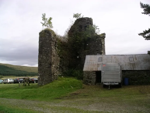
Achallader Castle
Castles · 3.2 km

Achallader Castle (ruins)
Castles · 3.2 km

Bridge of Orchy railway station
Historic bridges · 3.3 km

West Highland Way Sleeper
Hostels · 3.3 km

memorial to Duncan Ban MacIntyre
Memorials & monuments · 3.4 km
Nearby
📷 3Archaeological sites · Central Scotland
Eilean an Stalcair
Eilean an Stalcair — a archaeological in scotland-highlands, United Kingdom.
Mountains & hills · Central Scotland
Black Mount
Black Mount in Scotland Islands, United Kingdom.
📷 5Mountains & hills · Central Scotland
Mam Carraigh
Mam Carraigh — mountain in scotland highlands. Elevation: 361 m.
📷 5Historic bridges · Central Scotland
Victoria Bridge, Blackmount
Victoria Bridge, Blackmount — category B listed building-listed bridge in scotland-highlands, United Kingdom.
📷 5Historic bridges · Central Scotland
Bridge, Drochaid Tolaghan, Inveroran
Bridge, Drochaid Tolaghan, Inveroran — category C listed building-listed bridge in scotland-highlands, United Kingdom.
📷 3Viewpoints · Central Scotland
Loch Tulla Viewpoint
Loch Tulla Viewpoint is a viewpoint in the United Kingdom.
Where to eat & stay near Loch Tulla
Places to stay
📷 5Hostels · Central Scotland
West Highland Way Sleeper
West Highland Way Sleeper — a hostel in scotland highlands.
 📷 5
📷 5Campsites · Scottish Highlands
Glencoe Mountain Resort
Glencoe Mountain Resort — a campsite in scotland highlands.
 📷 5📷 5📷 5📷 5
Campsites · Central Scotland
By the Way
By the Way — a campsite in scotland highlands.
Places to eat & drink
 📷 4
📷 4Historic pubs · Scottish Highlands
Clachaig Inn
Clachaig Inn in Scotland Islands, United Kingdom.
 📷 5
📷 5Historic pubs · Central Scotland
The Drovers Inn
The Drovers Inn — Historic pub — listed building or notable heritage status.
More natural landmarks in this region
 📷 4
📷 4Natural landmarks · Central Scotland
Blackadder Water
Blackadder Water in England North East, United Kingdom.
 📷 3
📷 3Natural landmarks · Central Scotland
A6105 road
A6105 road in England North East, United Kingdom.
 📷 3
📷 3 📷 3
📷 3Frequently asked questions
- Where is Loch Tulla?
- Loch Tulla is in the Scottish Highlands, United Kingdom.
- What is Loch Tulla?
- Loch Tulla — lake in Argyll and Bute, Scotland, UK, outflows south to the River Ochry.
- How do I get to Loch Tulla?
- The nearest railway station is Bridge of Orchy, about 3.3 km away. Its coordinates are 56.5450°, -4.7756°.
- Is Loch Tulla free to visit?
- Yes, Loch Tulla is free to enter.
- How do I get to Loch Tulla?
- The nearest railway station is Bridge of Orchy, about 3.3 km away.