Natural landmarks · Northern Ireland
Lisnagarvey
In or near Lisburn.
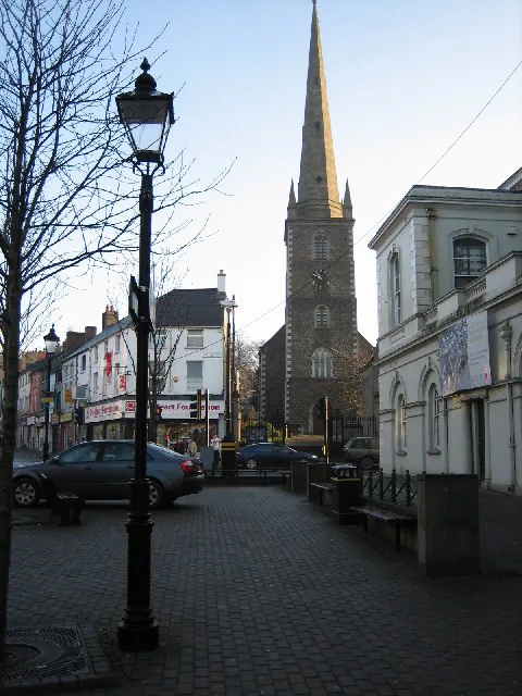
Lisnagarvey in Northern Ireland, United Kingdom.

Albert Bridge — CC BY-SA 2.0 via Wikimedia Commons licence
_-_geograph.org.uk_-_3556913.jpg)
Plan your visit
- Typical visit
- 1 h–2 h
- Nearest railway station
- Lisburn · 0.4 km
- Free entry
- Dog-friendly
Getting there & planning your visit
To visit Lisnagarvey, the nearest railway station is Lisburn, located 0.4 km away. Entry is free, and the postcode for sat-nav is BT28 3BB.
About
Lisnagarvey is a place of interest in Northern Ireland, United Kingdom — drawn from open-data sources for visitor reference. See the linked Wikipedia article for the full description.
Photo gallery
From the Wikipedia article
Lisnagarvey or Lisnagarvy (from Irish Lios na gCearrbhach, meaning 'fort of the gamester') is a townland in County Antrim, Northern Ireland. The townland was named after an earthen ringfort (lios), which was in the area of present-day "Fort Hill" in Lisburn. Today, most of the north-eastern part of Lisburn is within Lisnagarvey townland. Its eastern boundary is the River Lagan, its southern boundary is Governor's Road and its western boundary is Antrim Street/Antrim Road. It includes Wallace Park, Christ Church Cathedral and Thompson House Hospital. The name has been used for Lisnagarvey High School, Lisnagarvey Hockey Club and Lisnagarvey transmitting station, although none of these are within the townland itself. When David Trimble, the former First Minister, was created a peer, he took the title Baron Trimble, of Lisnagarvey in the County of Antrim. Lisnagarvey was the site of a defeat of the mostly Scottish Royalists at the hands of the Parliamentarians in 1649.
Excerpt from Wikipedia under CC BY-SA 4.0. See the source article linked in Sources below.
- Coordinates
- 54.5161, -6.0414
- District
- Lisburn and Castlereagh
- Postcode
- BT28 3BB
- Parliamentary constituency
- Lagan Valley
- Nearest railway station
- Lisburn — 0.4 km
Sources
- wikidata: Q6559034 (CC0)
- wikipedia: Lisnagarvey (CC BY-SA 4.0)
Other places nearby

Wallace Park
Parks · 0.2 km
Friends' School, Lisburn
Natural landmarks · 0.3 km

Lisburn Courthouse
Natural landmarks · 0.3 km

South Eastern Regional College
Natural landmarks · 0.3 km

Lisburn railway station
Natural landmarks · 0.4 km

The Rescue
Public art & sculpture · 0.4 km

Lisburn War Memorial
Memorials & monuments · 0.5 km

Old Town Hall, Lisburn
Historic houses · 0.5 km
Lisburn
Towns & cities · 0.5 km

The Wallace Memorial
Memorials & monuments · 0.5 km

The Crimean Cannon
Memorials & monuments · 0.5 km

Christ Church Cathedral, Lisburn
Cathedrals · 0.6 km
Nearby
📷 3📷 3Natural landmarks · Northern Ireland
Friends' School, Lisburn
Friends' School, Lisburn in Northern Ireland, United Kingdom.
📷 4Natural landmarks · Northern Ireland
Lisburn Courthouse
Lisburn Courthouse in Northern Ireland, United Kingdom.
📷 3Natural landmarks · Northern Ireland
South Eastern Regional College
South Eastern Regional College in Northern Ireland, United Kingdom.
📷 5Natural landmarks · Northern Ireland
Lisburn railway station
Lisburn railway station in Northern Ireland, United Kingdom.
📷 3Public art & sculpture · Northern Ireland
The Rescue
The Rescue — a public art in northern-ireland, United Kingdom.
Where to eat & stay near Lisnagarvey
Places to stay
 📷 3
📷 3Caravan parks · Northern Ireland
Standing Stones Lodge Caravan Park
Standing Stones Lodge Caravan Park — a caravan park in northern ireland.
 📷 7
📷 7 📷 5
📷 5Hostels · Northern Ireland
Paddy's Palace Belfast
Paddy's Palace Belfast — a hostel in northern ireland.
📷 5Hostels · Northern Ireland
Botanical Backpackers
Botanical Backpackers — a hostel in northern ireland.
 📷 5
📷 5Hostels · Northern Ireland
Vagabonds Belfast Hostel
Vagabonds Belfast Hostel — a hostel in northern ireland.
 📷 6
📷 6Places to eat & drink
 📷 5
📷 5 📷 3
📷 3Historic pubs · Northern Ireland
Red Lion Pub bombing
Red Lion Pub bombing in Northern Ireland, United Kingdom.
 📷 7
📷 7Historic pubs · Northern Ireland
Crown Liquor Saloon
Crown Liquor Saloon in Northern Ireland, United Kingdom.
 📷 7
📷 7Historic pubs · Northern Ireland
Kelly's Cellars
Kelly's Cellars in Northern Ireland, United Kingdom.
 📷 5
📷 5 📷 5
📷 5More natural landmarks in this region
 Flagship📷 4
Natural landmarks · Northern Ireland
Lough Erne
Lough Erne — lake in County Fermanagh, Northern Ireland, UK.
 Flagship📷 4
Natural landmarks · Northern Ireland
Lough Neagh
Lough Neagh — large lake in Northern Ireland.
 📷 3
📷 3Natural landmarks · Northern Ireland
Ballysaggart Lough
Ballysaggart Lough — lake in the United Kingdom.
 📷 5
📷 5Natural landmarks · Northern Ireland
Belmore Mountain
Belmore Mountain — mountain in the United Kingdom.
Frequently asked questions
- Where is Lisnagarvey?
- Lisnagarvey is in Northern Ireland, United Kingdom (postcode BT28 3BB).
- What is Lisnagarvey?
- Lisnagarvey in Northern Ireland, United Kingdom.
- How do I get to Lisnagarvey?
- The nearest railway station is Lisburn, about 0.4 km away. Drivers can use postcode BT28 3BB.
- Is Lisnagarvey free to visit?
- Yes, Lisnagarvey is free to enter.
- How do I get to Lisnagarvey?
- The nearest railway station is Lisburn, about 0.4 km away. Drivers can navigate to postcode BT28 3BB.