Natural landmarks · North West England
Lambrigg Fell
In or near Grayrigg.
Lambrigg Fell — 339m high mountain in England.

Wikimedia Commons contributors — see linked file page for photographer and licence licence
Plan your visit
- Typical visit
- 1 h–2 h
- Nearest railway station
- Kendal · 6.8 km
- Free entry
- Dog-friendly
Getting there & planning your visit
To visit Lambrigg Fell, the nearest railway station is Kendal, located 6.8 km away. The postcode for sat-nav is LA8 0AY, and entry is free.
About
Lambrigg Fell is a named natural landmark in the United Kingdom. Wikidata describes it as: "339m high mountain in England". Coordinates: 54.3415°, -2.6370°.
Photo gallery
From the Wikipedia article
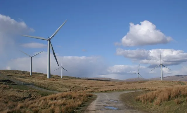
Lambrigg Fell is a hill, the highest point of the area of high ground between Kendal and the M6, in south-eastern Cumbria, England. It lies just outside the area normally defined as the Lake District, and the hill is not in the same mould as the nearby Lakeland Fells, being a sprawling, grassy moorland. For this reason, it is not nearly as popular as its subsidiary top to the west, Benson Knott, which overlooks Kendal. However, the hill provides close-range views of both the Howgill Fells and the Lake District, together with the Yorkshire Dales. The hill can be accessed by the minor road linking Docker and Lambrigg Head, which runs across the northern slopes of the fell. However, car parking is very limited near to the access gate. A track runs most of the way towards the summit, passing a small reservoir. The landowner is strongly opposed to use of this track from the top sheepfold onwards and the right of way follows a due south route over boggy ground from the top sheepfold. This gives a walk of about two and a half miles. Note that the right of way does not reach the summit and the landowner has acted to prevent those making the 200metre diversion to get to the top. Some 100 metres west of the summit, on the eastern side of the bridleway, the ruins of a small building may be seen. The exact nature of this structure is unclear, but local residents state that it was used as a shelter for members of shooting parties on the fell. It is possible to continue in a southerly direction along the bridleway and complete the walk by joining the A684, Sedbergh Road. There is a large wind farm owned by Innogy just to the east of the summit. The wind farm, which can generate 6.5 Megawatts of electricity, was opened in September 2000 and at that time it was the largest wind farm to be built in England since 1993. The land on which the wind farm is built is out of bounds to unauthorized personnel. The block of land of which Lambrigg Fell is the summit — thus making it a Marilyn…
Excerpt from Wikipedia under CC BY-SA 4.0. See the source article linked in Sources below.
- Coordinates
- 54.3415, -2.6370
- District
- Westmorland and Furness
- Parish
- New Hutton
- Postcode
- LA8 0AY
- Parliamentary constituency
- Westmorland and Lonsdale
- Nearest railway station
- Kendal — 6.8 km
Sources
- wikidata: Q6481555 (CC0)
- wikipedia: Lambrigg Fell (CC BY-SA 4.0)
- commons: Lambrigg wind farm.jpg (CC BY-SA 4.0)
Other places nearby
Lambrigg Fell
Mountains & hills · 0.1 km

Lambrigg Fell NW Top
Mountains & hills · 0.2 km

Lambrigg Fell SW Top
Mountains & hills · 0.2 km

Lambrigg Fell
Mountains & hills · 0.9 km

Summerhouse Hill
Mountains & hills · 2.1 km
Green Bank
Mountains & hills · 2.1 km

Firbank Fell
Natural landmarks · 2.1 km

Docker Viaduct
Historic bridges · 2.6 km

Firbank Fell
Mountains & hills · 2.8 km

Grayrigg
Towns & cities · 3.0 km

The Planting Hill
Mountains & hills · 3.0 km

The Planting
Mountains & hills · 3.1 km
Nearby
📷 3📷 5Mountains & hills · North West England
Lambrigg Fell NW Top
Lambrigg Fell NW Top — mountain in england north west. Elevation: 339 m.
📷 5Mountains & hills · North West England
Lambrigg Fell SW Top
Lambrigg Fell SW Top — mountain in england north west. Elevation: 338 m.
📷 5Mountains & hills · North West England
Lambrigg Fell
Lambrigg Fell — a hill or mountain in england north west.
📷 5Mountains & hills · North West England
Summerhouse Hill
Summerhouse Hill — a hill or mountain in england north west.
📷 5Mountains & hills · North West England
Green Bank
Green Bank — mountain in england north west. Elevation: 334 m.
Where to eat & stay near Lambrigg Fell
Places to stay
 📷 5
📷 5Campsites · North West England
Holme Open Farm
Holme Open Farm — a campsite in england north west.
 📷 5
📷 5Caravan parks · North West England
Kendal Camping and Caravanning Club
Kendal Camping and Caravanning Club — a caravan park in england north west.
 📷 5
📷 5Caravan parks · North West England
Spital Caravans
Spital Caravans — a caravan park in england north west.
 📷 5
📷 5Caravan parks · North West England
Poppy Farm Caravan Park
Poppy Farm Caravan Park — a caravan park in england north west.
 📷 5
📷 5Campsites · North West England
Farm & Fell
Farm & Fell — a campsite in england north west.
 📷 5
📷 5Hotels · North West England
The Black Bull
The Black Bull — a hotel in england north west.
Places to eat & drink
 📷 5
📷 5Cafés · North West England
Gun Dog Coffee Shop
Gun Dog Coffee Shop — a café in england north west.
 📷 5
📷 5Cafés · North West England
The Cross Keys Temperance Inn
The Cross Keys Temperance Inn — a café in england north west.
 📷 7
📷 7Historic pubs · North West England
Hole in t'Wall public house, With Attached Buildings To South
Hole in t'Wall public house, With Attached Buildings To South in England North West, United Kingdom.
 📷 7
📷 7Cafés · North West England
Joey's Cafe
Joey's Cafe — a café in england north west.
 📷 5
📷 5Historic pubs · North West England
Holbeck Ghyll
Holbeck Ghyll in England North West, United Kingdom.
 📷 4
📷 4Restaurants · North West England
Holbeck Ghyll
Holbeck Ghyll is a restaurant located in Windermere, Cumbria, England. "The late 19th century building was once Lord Lonsdale's hunting lodge and only became a hotel in the 1970s. It won a Michelin st
More natural landmarks in this region
 📷 3
📷 3Natural landmarks · North West England
Statue of Oliver Cromwell
Statue of Oliver Cromwell — Public artwork (statue).
 📷 3
📷 3Natural landmarks · North West England
Dagfields Craft Centre
Dagfields Craft Centre — a other in england-west-midlands, United Kingdom.
 📷 3
📷 3Natural landmarks · North West England
Weaver Valley Cruises
Weaver Valley Cruises — a other in england-west-midlands, United Kingdom.
 📷 3
📷 3Natural landmarks · North West England
Golden Gates
Golden Gates — a other in england-west-midlands, United Kingdom.
Frequently asked questions
- Where is Lambrigg Fell?
- Lambrigg Fell is in North-West England, United Kingdom (postcode LA8 0AY), in the parish of New Hutton.
- What is Lambrigg Fell?
- Lambrigg Fell — 339m high mountain in England.
- How do I get to Lambrigg Fell?
- The nearest railway station is Kendal, about 6.8 km away. Drivers can use postcode LA8 0AY.
- Is Lambrigg Fell free to visit?
- Yes, Lambrigg Fell is free to enter.
- How do I get to Lambrigg Fell?
- The nearest railway station is Kendal, about 6.8 km away. Drivers can navigate to postcode LA8 0AY.