Natural landmarks · Northern Ireland
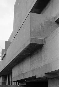
Laganbank
In or near Belfast.
Laganbank in Northern Ireland, United Kingdom.

Ross — CC BY-SA 2.0 via Wikimedia Commons licence
Plan your visit
- Typical visit
- 1 h–2 h
- Nearest railway station
- Botanic · 0.6 km
- Free entry
- Family-friendly
- Dog-friendly
- Wheelchair accessible
About
Laganbank is a place of interest in Northern Ireland, United Kingdom — drawn from open-data sources for visitor reference. See the linked Wikipedia article for the full description.
Photo gallery
Official information
National Museums NI manages four museums in Northern Ireland, showcasing a vast collection of 1.4 million objects related to art, history, and natural sciences. Visitors can explore the Ulster Museum, Ulster Folk Museum, Ulster Transport Museum, and Ulster American Folk Park, each offering unique insights into different aspects of culture and history.
From the Wikipedia article
Laganbank was one of the nine district electoral areas in Belfast, Northern Ireland which existed from 1985 to 2014. Located in the south of the city, the district elected five members to Belfast City Council and contained the wards of Ballynafeigh, Botanic, Shaftesbury, Stranmillis, and Rosetta. Laganbank, along with neighbouring Balmoral, formed the greater part of the Belfast South constituencies for the Northern Ireland Assembly and UK Parliament. The district was bound to the west by the Malone Road and the M1 Motorway, to the south by the River Lagan and the southern section of the Annadale Embankment, to the east by the Ormeau Park and the Ormeau Road and to the north by College Square North and the Cathedral Quarter. The River Lagan, which gave the district its name, flowed through the centre of the district dividing it in two, with Botanic, Shaftesbury and Stranmillis on the western bank and Ballynafeigh and Rosetta on the eastern bank. Laganbank also contained most of the city centre, including Donegall Square. The south of the district contained some of the most exclusive addresses in Northern Ireland, particularly along the Malone Road. However, the north of the district has areas that suffer economic deprivation, including Donegall Road, Sandy Row and 'the Markets'.
Excerpt from Wikipedia under CC BY-SA 4.0. See the source article linked in Sources below.
Background
History
Laganbank was created for the 1985 local elections. The Shaftesbury ward had previously been in Area F, Stranmillis and Botanic wards in Area C and Rosetta and Ballynafeigh wards in Area A. For the 2014 local elections, the district was abolished. With the exception of the Rosetta ward, which joined a new Lisnasharragh District Electoral Area, the district's redrawn wards formed part of a new Botanic District Electoral Area, together with the wards of Blackstaff and Windsor, which had previously been part of Balmoral District Electoral Area
Sourced from Wikipedia under CC BY-SA 4.0.
- Coordinates
- 54.5832, -5.9338
- District
- Belfast
- Postcode
- BT9 5AB
- Parliamentary constituency
- Belfast South and Mid Down
- Phone
- +44 845 608 0000
- Nearest railway station
- Botanic — 0.6 km
- Official site
- www.nmni.com
Sources
- wikidata: Q15241247 (CC0)
- wikipedia: Laganbank (District Electoral Area) (CC BY-SA 4.0)
Other places nearby

Queen's University of Belfast
Natural landmarks · 0.0 km

Palm House
Historic houses · 0.0 km

Eco
Public art & sculpture · 0.1 km

Queen's University Belfast
Natural landmarks · 0.1 km

New Metal Piece
Public art & sculpture · 0.1 km

Lord Kelvin's Statue
Natural landmarks · 0.2 km
Ulster Museum
Museums · 0.2 km

Galileo Galilei
Public art & sculpture · 0.2 km
Reclining Figure
Public art & sculpture · 0.2 km

Friar's Bush Cemetery
Cemeteries · 0.2 km

The Naughton Gallery at Queen's
Galleries · 0.2 km

Queen's Film Theatre
Theatres · 0.2 km
Nearby
📷 3Natural landmarks · Northern Ireland
Queen's University of Belfast
Queen's University of Belfast in Northern Ireland, United Kingdom.
📷 3Historic houses · Northern Ireland
Palm House
Palm House — a other in northern-ireland, United Kingdom.
📷 3📷 4Natural landmarks · Northern Ireland
Queen's University Belfast
Queen's University Belfast in Northern Ireland, United Kingdom.
📷 3Public art & sculpture · Northern Ireland
New Metal Piece
New Metal Piece — a public art in northern-ireland, United Kingdom.
📷 3Natural landmarks · Northern Ireland
Lord Kelvin's Statue
Lord Kelvin's Statue — a other in northern-ireland, United Kingdom.
Where to eat & stay near Laganbank
Places to stay
 📷 7
📷 7 📷 6
📷 6 📷 5
📷 5Hostels · Northern Ireland
Lagan Backpackers
Lagan Backpackers — a hostel in northern ireland.
 📷 5📷 5📷 5
Places to eat & drink
 📷 5
📷 5 📷 3
📷 3Historic pubs · Northern Ireland
Red Lion Pub bombing
Red Lion Pub bombing in Northern Ireland, United Kingdom.
 📷 7
📷 7Historic pubs · Northern Ireland
Crown Liquor Saloon
Crown Liquor Saloon in Northern Ireland, United Kingdom.
 📷 7
📷 7Historic pubs · Northern Ireland
Kelly's Cellars
Kelly's Cellars in Northern Ireland, United Kingdom.
 📷 5
📷 5 📷 5
📷 5More natural landmarks in this region
 Flagship📷 4
Natural landmarks · Northern Ireland
Lough Erne
Lough Erne — lake in County Fermanagh, Northern Ireland, UK.
 Flagship📷 4
Natural landmarks · Northern Ireland
Lough Neagh
Lough Neagh — large lake in Northern Ireland.
 📷 3
📷 3Natural landmarks · Northern Ireland
Ballysaggart Lough
Ballysaggart Lough — lake in the United Kingdom.
 📷 5
📷 5Natural landmarks · Northern Ireland
Belmore Mountain
Belmore Mountain — mountain in the United Kingdom.
Frequently asked questions
- Where is Laganbank?
- Laganbank is in Northern Ireland, United Kingdom (postcode BT9 5AB).
- What is Laganbank?
- Laganbank in Northern Ireland, United Kingdom.
- How do I get to Laganbank?
- The nearest railway station is Botanic, about 0.6 km away. Drivers can use postcode BT9 5AB.
- Is Laganbank free to visit?
- Yes, Laganbank is free to enter.
- How do I get to Laganbank?
- The nearest railway station is Botanic, about 0.6 km away. Drivers can navigate to postcode BT9 5AB.