
Historic houses · North East England
Kirkharle Hall
In or near Bolam.
Kirkharle Hall in England North East, United Kingdom.

Mike Quinn — CC BY-SA 2.0 via Wikimedia Commons licence

Plan your visit
- Typical visit
- 1 h–2 h
- Family-friendly
- Limited wheelchair access
About
Kirkharle Hall is a place of interest in England North East, United Kingdom — drawn from open-data sources for visitor reference. See the linked Wikipedia article for the full description.
Photo gallery
Protected designations
- Site of Special Scientific Interest: Northumberland Shore SSSI
Designations sourced from Natural England open data under OGL v3.
From the Wikipedia article
Kirkharle Hall is a remnant of a country house at Kirkharle, Northumberland, England, the former seat of the Loraine family, now much reduced and in use as a farmhouse. The Hall is in the upper reaches of the Wansbeck valley; almost adjacent to the A696 road; 12 miles (19 km) west of Morpeth; and 2 miles (3.2 km) southeast of Kirkwhelpington.
Excerpt from Wikipedia under CC BY-SA 4.0. See the source article linked in Sources below.
Background
History
Kirkharle name was first recorded, as Herle in 1177, and derives either from the Old English "Herela-lea" which means "Herela's Grove" or from the Old English "herg-lea" which means "temple-grove" a place of worship for the pre-Christian Angles. Other early forms included Kyrkeherle (c.1250), Kyrkherll (1346) and Kirkehirle (1428), and derived their name (literally "of Harle") from the village. Following its sale to a local farmer in the early 19th century the Hall was largely demolished. Only one wing was retained which was rebuilt as a farmhouse. It is a Grade II listed building. Nearby stands a memorial stone erected in 1728 to replace an earlier memorial commemorating Robert Loraine who…
Sourced from Wikipedia under CC BY-SA 4.0.
- Coordinates
- 55.1364, -1.9795
- District
- Northumberland
- Parish
- Kirkwhelpington
- Postcode
- NE19 2PE
- Parliamentary constituency
- Hexham
Sources
- wikidata: Q6415675 (CC0)
- wikipedia: Kirkharle Hall (CC BY-SA 4.0)
Other places nearby

Kirkharle
Other places · 0.1 km
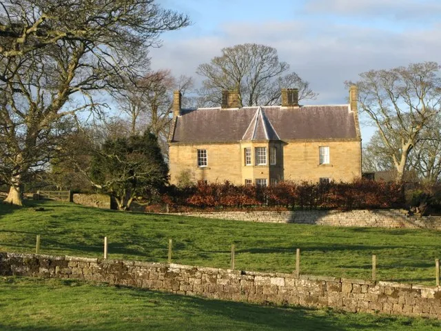
Kirkharle Manor
Stately homes · 0.2 km
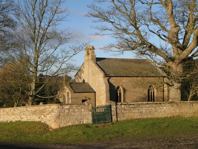
Church of St Wilfred, Kirkharle
Historic churches · 0.3 km

Kirkharle
Villages · 0.6 km

Little Harle Tower
Historic houses · 1.0 km

Bridge Approx 30 Yards North Of Clock Mill
Historic bridges · 1.7 km

A696 road
Other places · 2.3 km

4 Stone Dragons Heads On Lawn East Of Hall
Public art & sculpture · 2.4 km

Elementree
Public art & sculpture · 2.5 km

Standing Stone On East Side Of Chinese Pond
Windmills · 2.6 km

Kirkwhelpington Bridge
Historic bridges · 2.6 km

Kirkwhelpington
Other places · 2.6 km
Nearby
📷 4Flagship📷 3Stately homes · North East England
Kirkharle Manor
Kirkharle Manor — manor house in Kirkwhelpington, Northumberland, England, UK.
📷 3Historic churches · North East England
Church of St Wilfred, Kirkharle
Church of St Wilfred, Kirkharle — Grade I listed church in Kirkharle, Northumberland, England, UK.
📷 5📷 2Historic houses · North East England
Little Harle Tower
Little Harle Tower in England North East, United Kingdom.
📷 3Historic bridges · North East England
Bridge Approx 30 Yards North Of Clock Mill
Bridge Approx 30 Yards North Of Clock Mill — Grade II listed building-listed bridge in scotland-lowlands, United Kingdom.
Where to eat & stay near Kirkharle Hall
Places to stay
 📷 5
📷 5Caravan parks · North East England
Elf Hills CL Site
Elf Hills CL Site — a caravan park in scotland lowlands.
 📷 5
📷 5Caravan parks · North East England
Well House CAMC CL
Well House CAMC CL — a caravan park in scotland lowlands.
 📷 5
📷 5Caravan parks · North East England
Barrasford Park Caravan Site
Barrasford Park Caravan Site — a caravan park in scotland lowlands.
📷 5Campsites · North East England
Barrasford Park Camping Site
Barrasford Park Camping Site — a campsite in scotland lowlands.
 📷 3
📷 3Campsites · North East England
Nunnykirk Scout Campsite
Nunnykirk Scout Campsite — a campsite in scotland lowlands.
 📷 5
📷 5Campsites · North East England
Selby Woods Scout Campsite
Selby Woods Scout Campsite — a campsite in scotland lowlands.
Places to eat & drink
 📷 5
📷 5 📷 7
📷 7 📷 5
📷 5Historic pubs · North East England
The Seven Stars Public House
The Seven Stars Public House in Scotland Lowlands, United Kingdom.
 📷 7
📷 7Historic pubs · North East England
The Vicars Pele
The Vicars Pele in Scotland Lowlands, United Kingdom.
 📷 5
📷 5Historic pubs · North East England
The Crown And Anchor
The Crown And Anchor in Scotland Lowlands, United Kingdom.
 📷 5
📷 5More historic houses in this region
 📷 3
📷 3Historic houses · North East England
Wayside cross known as Jenny Bradley 1000m north west of Bloworth Crossing on Greenhow Moor
Wayside cross known as Jenny Bradley 1000m north west of Bloworth Crossing on Greenhow Moor — a Grade II*-listed historic house in england-yorkshire, United Kingdom.
 📷 3
📷 3Historic houses · North East England
Crackpot Hall
Crackpot Hall — a historic house in england-north-west, United Kingdom.
 📷 3
📷 3Historic houses · North East England
Bunton Mine shop
Bunton Mine shop — a historic house in england-north-west, United Kingdom.
 📷 3
📷 3Historic houses · North East England
Blakethwaite Mine
Blakethwaite Mine — a historic house in england-north-west, United Kingdom.
Frequently asked questions
- Where is Kirkharle Hall?
- Kirkharle Hall is in North-East England, United Kingdom (postcode NE19 2PE), in the parish of Kirkwhelpington.
- What is Kirkharle Hall?
- Kirkharle Hall in England North East, United Kingdom.
- How do I get to Kirkharle Hall?
- Drivers can use postcode NE19 2PE.
- Is Kirkharle Hall a protected site?
- Yes — Kirkharle Hall is part of the Northumberland Shore SSSI Site of Special Scientific Interest.
- How do I get to Kirkharle Hall?
- Drivers can navigate to postcode NE19 2PE. It sits within the Hexham parliamentary constituency.