
Caves · South Wales
King Arthurs Cave
In or near Symonds Yat.
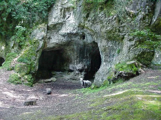
King Arthurs Cave is a cave in the United Kingdom.

Wikimedia Commons contributors — see linked file page for photographer and licence licence

Plan your visit
- Typical visit
- 45 min–1.5 h
- Nearest railway station
- Rookwood · 6.7 km
- Free entry
- Dog-friendly
Getting there & planning your visit
To visit King Arthur's Cave, the nearest railway station is Rookwood, located 6.7 km away. The postcode for the cave is HR9 6DZ, which you can use for sat-nav coordinates. Entry to the cave is free.
About
King Arthurs Cave is a named cave entrance in the United Kingdom. Coordinates: 51.8371°, -2.6608°. This entry is part of The Great Britain Guide, a free, ad-free, open-data tourist directory.
Photo gallery
Protected designations
- Site of Special Scientific Interest: Upper Wye Gorge SSSI
- Site of Special Scientific Interest: River Wye SSSI
- Area of Outstanding Natural Beauty: Wye Valley
Designations sourced from Natural England open data under OGL v3.
From the Wikipedia article
King Arthur's Cave is a limestone cave at the foot of a low cliff at the north-western end of Lord's Wood in The Doward, near Symonds Yat, Herefordshire, about four miles northeast of Monmouth, in the Wye Valley. The cave entrance lies about 285 feet above the River Wye on a hill, with a double interconnected entrance and two main chambers. It is protected as a nature reserve under the Herefordshire Nature Trust. There is evidence that the cave was occupied by man during the Upper Palaeolithic era, and flint tools and woolly mammoth bones have been unearthed within and around the caves.
Excerpt from Wikipedia under CC BY-SA 4.0. See the source article linked in Sources below.
Background
History
It is uncertain exactly how the cave got its name. A skeleton of a "giant human" was supposedly discovered in the cave around 1700, but was lost when a local surgeon named Mr. Pye took the skeleton to sea on a voyage to Jamaica and his ship sank. The cave is shrouded in local superstition and is believed to have had a part in the early legend of King Vortigern, a native British king who fought against the invading Anglo Saxons. Vortigern is said to have made his last stand against Aurelius at nearby Ganarew. Lawman mentions a castle on Cloard Hill in the district of Hergin, and has Vortigern dying after the castle was besieged and fired by Aurelius and Uther. Helen Hill Miller, in her 1969…
Architecture
The cave is said to "consist of a broad entrance platform, a double interconnected entrance and two main chambers", about 300 feet above the River Wye. The main chambers obtained the names Bear's Den and Lion's Cave due to the paleontological items found there. There are also several other open rooms to the cave.
Sourced from Wikipedia under CC BY-SA 4.0.
- Coordinates
- 51.8371, -2.6608
- District
- Herefordshire, County of
- Parish
- Whitchurch
- Postcode
- HR9 6DZ
- Parliamentary constituency
- Hereford and South Herefordshire
- Nearest railway station
- Rookwood — 6.7 km
Sources
- osm: n347432897 (ODbL)
- wikipedia: King Arthur's Cave (CC BY-SA 4.0)
- commons: King Arthur's Cave - geograph.org.uk - 88587.jpg (CC BY-SA 4.0)
Other places nearby
King Arthur's Cave
Mountains & hills · 0.0 km

Doward Park Campsite
Campsites · 0.3 km

Hill Fort Entrance
Hill forts · 0.6 km

Little Doward Hill
Archaeological sites · 0.7 km
Little Doward Iron Age Hill Fort
Hill forts · 0.8 km

Little Doward Iron Age Hill Fort
Archaeological sites · 0.8 km
Little Doward Camp
Vineyards · 0.8 km
Little Doward
Mountains & hills · 0.9 km

Great Doward
Mountains & hills · 0.9 km
Hermits Hut garden feature
Gardens · 1.0 km

Wye Valley Heritage Centre
Natural landmarks · 1.0 km

Biblins Youth Campsite
Campsites · 1.0 km
Nearby
📷 3Mountains & hills · South Wales
King Arthur's Cave
King Arthur's Cave — cave in Herefordshire, England, UK.
📷 5📷 3Hill forts · South Wales
Hill Fort Entrance
Hill Fort Entrance — a hill fort in wales-south, United Kingdom.
📷 3Archaeological sites · South Wales
Little Doward Hill
Little Doward Hill — a archaeological in wales-south, United Kingdom.
📷 3Hill forts · South Wales
Little Doward Iron Age Hill Fort
Little Doward Iron Age Hill Fort — a hill fort in wales-south, United Kingdom.
📷 5Archaeological sites · South Wales
Little Doward Iron Age Hill Fort
Little Doward Iron Age Hill Fort — archaeological in wales south.
Where to eat & stay near King Arthurs Cave
Places to stay
📷 5📷 5Campsites · South Wales
Biblins Youth Campsite
Biblins Youth Campsite — a campsite in wales south.
 📷 5
📷 5 📷 5
📷 5B&Bs · South West England
The Saracens Head
The Saracens Head — a bed-and-breakfast in wales south.
 📷 5
📷 5Caravan parks · South West England
Sterrett’s Caravan and Camping Park
Sterrett’s Caravan and Camping Park — a caravan park in wales south.
 📷 5
📷 5Campsites · South West England
River Wye Camping & Caravan Park
River Wye Camping & Caravan Park — a campsite in wales south.
Places to eat & drink
 📷 7
📷 7 📷 7
📷 7 📷 5
📷 5 📷 6
📷 6Historic pubs · South Wales
Queens Head
Queens Head in Wales South, United Kingdom.
 📷 5
📷 5 📷 5
📷 5Historic pubs · South Wales
The Punch House
The Punch House — Historic pub — listed building or notable heritage status.
More caves in this region
 📷 3
📷 3Caves · South Wales
Agen Allwedd (Ogof Gam)
Agen Allwedd (Ogof Gam) is a cave in the United Kingdom.
 📷 3
📷 3 📷 3
📷 3 📷 3
📷 3Frequently asked questions
- Where is King Arthurs Cave?
- King Arthurs Cave is in South Wales, United Kingdom (postcode HR9 6DZ), in the parish of Whitchurch.
- What is King Arthurs Cave?
- King Arthurs Cave is a cave in the United Kingdom.
- How do I get to King Arthurs Cave?
- The nearest railway station is Rookwood, about 6.7 km away. Drivers can use postcode HR9 6DZ.
- Is King Arthurs Cave a protected site?
- Yes — King Arthurs Cave is part of the Upper Wye Gorge SSSI Site of Special Scientific Interest and the River Wye SSSI Site of Special Scientific Interest.
- Is King Arthurs Cave free to visit?
- Yes, King Arthurs Cave is free to enter.
- How do I get to King Arthurs Cave?
- The nearest railway station is Rookwood, about 6.7 km away. Drivers can navigate to postcode HR9 6DZ.