
Historic churches · East Midlands
Kexby, Lincolnshire
In or near Torksey.
Kexby is a small village and civil parish in the West Lindsey district of Lincolnshire, England. The population of the civil parish at the 2011 census was 340. It lies at the side of the B1241 road,

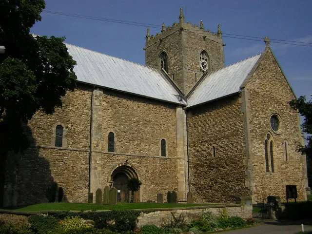
Mat Fascione — CC BY-SA 2.0 via Wikimedia Commons licence

Plan your visit
- Typical visit
- 30 min–1 h
- Nearest railway station
- Gainsborough Lea Road · 6.0 km
- Free entry
About
Kexby is a small village and civil parish in the West Lindsey district of Lincolnshire, England. The population of the civil parish at the 2011 census was 340. It lies at the side of the B1241 road, and is situated 4 miles (6 km) south-east of Gainsborough and 11 miles (18 km) north-west of the city and county town of Lincoln.
Photo gallery
Protected designations
- Ramsar wetland: Humber Estuary
Designations sourced from Natural England open data under OGL v3.
From the Wikipedia article
Kexby is a small village and civil parish in the West Lindsey district of Lincolnshire, England. The population of the civil parish at the 2011 census was 340. It lies at the side of the B1241 road, and is situated 4 miles (6 km) south-east of Gainsborough and 11 miles (18 km) north-west of the city and county town of Lincoln.
Excerpt from Wikipedia under CC BY-SA 4.0. See the source article linked in Sources below.
Background
History
The earliest records for the village of Kexby can be found in the Domesday Book, which dates back to 1086. According to these reports, the village went by the name of Cheftesbi/Chestesbi. These records also highlight that Kexby was home to 21 households which was considered to be a relatively large number at this time. This point is backed up by the fact that in 1086, Kexby was the third largest settlement in the hundred of Well. This was out of the 15 settlements in the area. Although Kexby is a separate village and parish council, it is served by the church in the neighbouring village and parish council of Upton. The local ecclesiastical parish is Upton with Kexby in the Diocese of…
Visiting
As of 2011, the occupational status of many of Kexby's population has changed. The census report of 2011 highlights this shift. The most popular form of employment for Kexby now is in the professional trade, with 31 people working in this sector, 17% of the villages population. 28 people also work as Managers, Directors and Senior Officials, with 29 involved in the Skilled Trade sector. These statistics go to show how much the workplace has changed over the past 130 years since the 1881 census. Now, only 15 residents of Kexby work in Elementary Occupations, such as farming. Kexby itself does not contain any schools. However, there are primary schools located in the nearby villages of…
Sourced from Wikipedia under CC BY-SA 4.0.
- Coordinates
- 53.3621, -0.6885
- County
- Lincolnshire
- District
- West Lindsey
- Parish
- Kexby
- Postcode
- DN21 5LZ
- Parliamentary constituency
- Gainsborough
- Nearest railway station
- Gainsborough Lea Road — 6 km
Sources
- wikipedia: Kexby, Lincolnshire (CC BY-SA 4.0)
Other places nearby

Kexby
Villages · 0.0 km

Upton, Lincolnshire
Historic churches · 1.1 km

Upton
Villages · 1.1 km

Willingham
Villages · 1.4 km

Wesleyan Chapel
Chapels · 2.5 km

Heapham
Villages · 2.5 km

Sturgate
Villages · 3.4 km

Somerby by Gainsborough
Historic churches · 3.6 km

Springthorpe
Historic churches · 3.9 km
Stow Minster
Historic churches · 3.9 km

Stow
Villages · 4.0 km

Lea
Villages · 4.1 km
Nearby
📷 5📷 5Historic churches · East Midlands
Upton, Lincolnshire
Upton is a small village and civil parish in the West Lindsey district of Lincolnshire, England. The population of the civil parish at the 2011 census was 456. It is geographically situated 3 miles (
📷 5📷 5📷 3Chapels · East Midlands
Wesleyan Chapel
Wesleyan Chapel — chapel in Heapham, West Lindsey, Lincolnshire, England, UK.
📷 5Where to eat & stay near Kexby, Lincolnshire
Places to stay
 📷 5
📷 5 📷 5
📷 5Caravan parks · East Midlands
Little London Park
Little London Park — a caravan park in england east midlands.
 📷 5
📷 5Campsites · East Midlands
Trentfield Farm
Trentfield Farm — a campsite in england east midlands.
 📷 5
📷 5Caravan parks · East Midlands
Manor House Caravan Park
Manor House Caravan Park — a caravan park in england east midlands.
 📷 5
📷 5Campsites · East Midlands
Waterfront Country Park
Waterfront Country Park — a campsite in england east midlands.
 📷 5
📷 5Campsites · East Midlands
Lincolnshire Lanes
Lincolnshire Lanes — a campsite in england east midlands.
Places to eat & drink
 📷 5
📷 5Historic pubs · East Midlands
Ingelby Arms Public House
Ingelby Arms Public House in England Yorkshire, United Kingdom.
 📷 5
📷 5 📷 7
📷 7Historic pubs · East Midlands
Black Boy Public House
Black Boy Public House in England Yorkshire, United Kingdom.
 📷 5
📷 5 📷 5
📷 5Restaurants · East Midlands
Cafe Zoot
Cafe Zoot — a restaurant in england east midlands.
 📷 7
📷 7More places in this region
 📷 5
📷 5Historic churches · East Midlands
All Saints' Church, Stamford
All Saints' Church, Stamford — church in Stamford, Lincolnshire, England, UK.
 📷 5
📷 5Historic churches · East Midlands
Church of All Saints
Church of All Saints — church in Little Casterton, Rutland, United Kingdom.
 📷 5
📷 5Historic churches · East Midlands
Church of All Saints
Church of All Saints — church in Fenland, UK.
 📷 5
📷 5Historic churches · East Midlands
Church of St Leonard
Church of St Leonard — church in Fenland, UK.
Frequently asked questions
- Where is Kexby, Lincolnshire?
- Kexby, Lincolnshire is in Lincolnshire, the East Midlands, United Kingdom (postcode DN21 5LZ), in the parish of Kexby.
- What is Kexby, Lincolnshire?
- Kexby is a small village and civil parish in the West Lindsey district of Lincolnshire, England. The population of the civil parish at the 2011 census was 340. It lies at the side of the B1241 road,
- How do I get to Kexby, Lincolnshire?
- The nearest railway station is Gainsborough Lea Road, about 6.0 km away. Drivers can use postcode DN21 5LZ.
- Is Kexby, Lincolnshire a protected site?
- Yes — Kexby, Lincolnshire is part of the Humber Estuary Ramsar wetland.
- Is Kexby, Lincolnshire free to visit?
- Yes, Kexby, Lincolnshire is free to enter.
- How do I get to Kexby, Lincolnshire?
- The nearest railway station is Gainsborough Lea Road, about 6.0 km away. Drivers can navigate to postcode DN21 5LZ.