Forests & woodlands · North East England
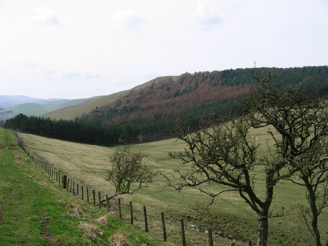
Howtel
In or near Branxton.
Howtel in England North East, United Kingdom.

Wikimedia Commons licence
Plan your visit
- Typical visit
- 1 h–3 h
- Nearest railway station
- Heatherslaw · 5.5 km
- Free entry
- Family-friendly
- Dog-friendly
About
Howtel is a place of interest in England North East, United Kingdom — drawn from open-data sources for visitor reference. See the linked Wikipedia article for the full description.
Photo gallery
Protected designations
- Site of Special Scientific Interest: Tweed Catchment Rivers - England: Till Catchment SSSI
Designations sourced from Natural England open data under OGL v3.
From the Wikipedia article
Howtel is a village and former civil parish, now in the parish of Kilham, in Northumberland, England about 8 miles (13 km) northwest of Wooler. The name Howtel is thought to mean Low Ground with a Holt or Wood. In 1951 the parish had a population of 75.
Excerpt from Wikipedia under CC BY-SA 4.0. See the source article linked in Sources below.
Background
History
Howtel once possessed a strong pele, mentioned in the report of Sir Robert Bowes on the Border in 1542 as one of several that had been "rased and casten downe" by the Scots. The surviving ruins of Howtel Tower are now surrounded by farm buildings. The village is listed, too, along with Lanton, Milfield, Heatherslaw, Branxton, Heaton, Pawston, and Mindrum in the order of the watch in this part of the Border, as set forth in an act of Edward VI's reign. The villages mentioned had to supply a nightly patrol of fourteen men, who made their rounds on horseback. At the close of the nineteenth century the Alnwick and Cornhill branch of the North East railway passed close by, and the nearest…
Sourced from Wikipedia under CC BY-SA 4.0.
- Coordinates
- 55.6040, -2.1680
- District
- Northumberland
- Parish
- Kilham
- Postcode
- TD12 4QG
- Parliamentary constituency
- North Northumberland
- Nearest railway station
- Heatherslaw — 5.5 km
Sources
Other places nearby

Howtel Field Camp
Vineyards · 0.4 km
Howtel tower house
Literary houses · 0.5 km

Branxton Moor
Vineyards · 1.2 km

Castle Hill camp
Vineyards · 1.4 km
Kypie Hill
Vineyards · 1.5 km

Branxtonmoor 2
Vineyards · 1.5 km

East Moneylaws camp
Vineyards · 1.7 km

Housedon Hill
Mountains & hills · 1.7 km

Branxton Hill South
Vineyards · 1.9 km
Housedon Hill
Natural landmarks · 1.9 km

Flodden Edge Camp
Vineyards · 2.0 km

Viewpoint near Thornington
Viewpoints · 2.0 km
Nearby
📷 5Vineyards · North East England
Howtel Field Camp
Howtel Field Camp — a UK vineyard in scotland central, producing English or Welsh wine from cool-climate grape varieties.
📷 5Literary houses · North East England
Howtel tower house
Howtel tower house — a literary house museum in scotland central.
📷 5Vineyards · North East England
Branxton Moor
Branxton Moor — a UK vineyard in scotland central, producing English or Welsh wine from cool-climate grape varieties.
Vineyards · North East England
Castle Hill camp
Castle Hill camp — a UK vineyard in scotland central, producing English or Welsh wine from cool-climate grape varieties.
Vineyards · North East England
Kypie Hill
Kypie Hill — a UK vineyard in scotland central, producing English or Welsh wine from cool-climate grape varieties.
📷 5Vineyards · North East England
Branxtonmoor 2
Branxtonmoor 2 — a UK vineyard in scotland central, producing English or Welsh wine from cool-climate grape varieties.
Where to eat & stay near Howtel
Places to stay
 📷 7
📷 7Hotels · North East England
Collingwood Arms
Collingwood Arms — a hotel in scotland central.
 📷 5
📷 5Campsites · Scottish Lowlands
Coldstream Holiday Park
Coldstream Holiday Park — a campsite in scotland central.
 📷 5
📷 5Hotels · North East England
Tillmouth Park Country House Hotel
Tillmouth Park Country House Hotel — a hotel in scotland central.
 📷 5
📷 5Hostels · North East England
Friends Of Nature House
Friends Of Nature House — a hostel in scotland central.
 📷 7
📷 7B&Bs · North East England
Mill House
Mill House — a bed-and-breakfast in scotland central.
 📷 5
📷 5Caravan parks · North East England
Kirkfield Caravan Site
Kirkfield Caravan Site — a caravan park in scotland central.
Places to eat & drink
 📷 4
📷 4Historic pubs · Scottish Lowlands
Newcastle Arms
Newcastle Arms — Historic pub — listed building or notable heritage status.
 📷 7
📷 7 📷 5
📷 5Historic pubs · Scottish Lowlands
The Masons Arms
The Masons Arms in Scotland Lowlands, United Kingdom.
 📷 7
📷 7Historic pubs · Scottish Lowlands
The Victoria Hotel
The Victoria Hotel in Scotland Lowlands, United Kingdom.
 📷 7
📷 7Historic pubs · North East England
59 And 61, Bridge Street
59 And 61, Bridge Street in Scotland Lowlands, United Kingdom.
 📷 5
📷 5Historic pubs · North East England
The Berwick Arms
The Berwick Arms in Scotland Lowlands, United Kingdom.
More forests in this region
 📷 3
📷 3Forests & woodlands · North East England
Berwick Hills Nature Reserve
Berwick Hills Nature Reserve is a forest or woodland in the United Kingdom.
 📷 4
📷 4Forests & woodlands · North East England
Maze Park
Maze Park is a forest or woodland in the United Kingdom.
 📷 3
📷 3Forests & woodlands · North East England
Portrack Marsh, Nature Reserve
Portrack Marsh, Nature Reserve is a forest or woodland in the United Kingdom.
 📷 3
📷 3Forests & woodlands · North East England
Saltholme Wildlife Reserve and Discovery Park
Saltholme Wildlife Reserve and Discovery Park is a forest or woodland in the United Kingdom.
Frequently asked questions
- Where is Howtel?
- Howtel is in North-East England, United Kingdom (postcode TD12 4QG), in the parish of Kilham.
- What is Howtel?
- Howtel in England North East, United Kingdom.
- How do I get to Howtel?
- The nearest railway station is Heatherslaw, about 5.5 km away. Drivers can use postcode TD12 4QG.
- Is Howtel a protected site?
- Yes — Howtel is part of the Tweed Catchment Rivers - England: Till Catchment SSSI Site of Special Scientific Interest.
- Is Howtel free to visit?
- Yes, Howtel is free to enter.
- How do I get to Howtel?
- The nearest railway station is Heatherslaw, about 5.5 km away. Drivers can navigate to postcode TD12 4QG.