
Cemeteries · East of England
Horningsea Cemetery
In or near Horningsea.
Horningsea Cemetery is a cemetery in the United Kingdom.

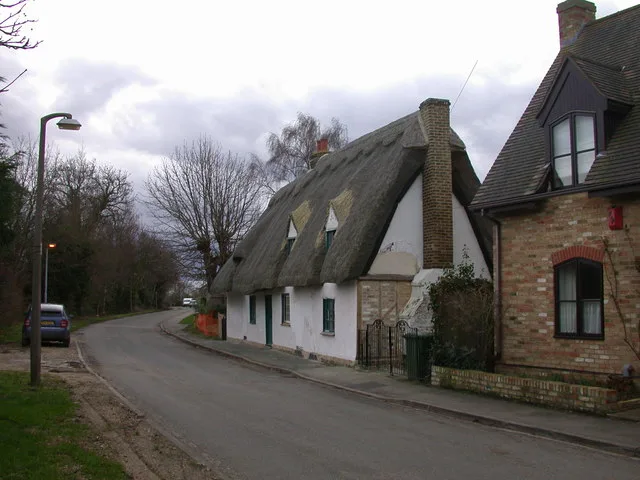
John Sutton — CC BY-SA 2.0 via Wikimedia Commons licence

Plan your visit
- Typical visit
- 30 min–1 h
- Nearest railway station
- Cambridge North · 2.1 km
- Free entry
- Dog-friendly
Getting there & planning your visit
To visit Horningsea Cemetery, the nearest railway station is Cambridge North, located 2.1 km away. The postcode for sat-nav is CB25 9JL, and entry to the cemetery is free.
About
Horningsea Cemetery is a cemetery in Cambridgeshire, London of architectural and local-history note. It sits within the South Cambridgeshire parliamentary constituency. The nearest railway station is Cambridge North, about 2.1 km away. Postcode area CB25.
Photo gallery
Official information
Horningsea Cemetery is a burial ground located in the village of Horningsea, Cambridgeshire. It serves as a resting place for the deceased and is part of the local community's heritage.
From the Wikipedia article
Horningsea is a small village north of Cambridge in Cambridgeshire in England. The parish covers an area of 2.6 square miles (6.7 km2; 1,700 acres). It lies on the east bank of the River Cam, and on the road from Cambridge to Clayhithe. The nearest railway station is Waterbeach, 1+1⁄2 miles (2.4 km) away. Listed as Horningesea in the Domesday Book, the village's name derives from either "Island (or dry ground in marsh) of a man called Horning" or "Island by the horn-shaped hill".
Excerpt from Wikipedia under CC BY-SA 4.0. See the source article linked in Sources below.
Background
History
Central to the development of Horningsea as a settlement has been its location on the River Cam, whose use for navigation dates back to at least Roman times. Around 4,000 years ago, the parish consisted of a chalk promontory between marshland and the sea, and there is evidence of Iron Age habitation. Around 1,000 years ago, it had become a peninsula extending northwards into the undrained fens. Drainage of the area began with Bottisham Lode in early medieval times, and a bridge is mentioned in the village in the late 13th century. In 1637 the Earl of Bedford was given 400 acres in Fen Ditton, Horningsea, and Stow cum Quy which were drained over the following 20 years. The remainder of the…
Sourced from Wikipedia under CC BY-SA 4.0.
- Coordinates
- 52.2358, 0.1832
- County
- Cambridgeshire
- District
- South Cambridgeshire
- Parish
- Horningsea
- Postcode
- CB25 9JL
- Parliamentary constituency
- South Cambridgeshire
- Nearest railway station
- Cambridge North — 2.1 km
- Official site
- www.ons.gov.uk
Sources
- osm: w39121641 (ODbL)
- wikipedia: Horningsea (CC BY-SA 4.0)
Other places nearby

The Plough And Fleece
Historic pubs · 0.3 km
Horningsea
Towns & cities · 0.6 km

Baits Bite Lock, River Cam
Canal locks · 0.6 km

Baits Bite Lock
Natural landmarks · 0.6 km

Crown & Punchbowl
Restaurants · 0.6 km

Gayton Farm
Caravan parks · 0.8 km

Sunclock
Public art & sculpture · 1.3 km

Painted Plough
Public art & sculpture · 1.4 km
.jpg?width=1200)
Milton House
Historic houses · 1.4 km

The Wild Place
Natural landmarks · 1.4 km

Milton War Memorial
Memorials & monuments · 1.6 km

Milton Village Sign
Public art & sculpture · 1.6 km
Nearby
📷 5Historic pubs · East of England
The Plough And Fleece
The Plough And Fleece in England East, United Kingdom.
Flagship📷 10Towns & cities · East of England
Horningsea
Horningsea — village and civil parish in Cambridgeshire, UK.
📷 5Canal locks · East of England
Baits Bite Lock, River Cam
Baits Bite Lock, River Cam is a canal lock in the United Kingdom.
📷 5Natural landmarks · East of England
Baits Bite Lock
Baits Bite Lock — a place in East of England, United Kingdom.
📷 5Restaurants · East of England
Crown & Punchbowl
Crown & Punchbowl — a restaurant in england london.
📷 5Where to eat & stay near Horningsea Cemetery
Places to stay
📷 5 📷 5
📷 5Caravan parks · East of England
Cosy Nook Caravan Park
Cosy Nook Caravan Park — a caravan park in england london.
 📷 7
📷 7 📷 5
📷 5Caravan parks · East of England
Lodeside Mobile Home Park
Lodeside Mobile Home Park — a caravan park in england london.
 📷 5
📷 5B&Bs · East of England
The Cambridge Guest House
The Cambridge Guest House — a bed-and-breakfast in england london.
 📷 5
📷 5Caravan parks · East of England
Kingsmead Caravan Park
Kingsmead Caravan Park — a caravan park in england london.
Places to eat & drink
📷 5Historic pubs · East of England
The Plough And Fleece
The Plough And Fleece in England East, United Kingdom.
📷 5Restaurants · East of England
Crown & Punchbowl
Crown & Punchbowl — a restaurant in england london.
 📷 5
📷 5Historic pubs · East of England
Lion And Lamb Public House
Lion And Lamb Public House in England East, United Kingdom.
 📷 7
📷 7Historic pubs · East of England
King's Head Public House
King's Head Public House in England East, United Kingdom.
 📷 7
📷 7Historic pubs · East of England
The Globe Public House
The Globe Public House in England East, United Kingdom.
 📷 6
📷 6Historic pubs · East of England
Fort St George In England
Fort St George In England in England East, United Kingdom.
More cemeteries in this region
 📷 5
📷 5Cemeteries · East of England
Arbory Trust Woodland Cemetery
Arbory Trust Woodland Cemetery is a cemetery in the United Kingdom.
 📷 5
📷 5Cemeteries · East of England
Ascension Parish Burial Ground
Ascension Parish Burial Ground is a cemetery in the United Kingdom.
 📷 5
📷 5Cemeteries · East of England
Baldock Cemetery
Baldock Cemetery is a cemetery in the United Kingdom.
 📷 5
📷 5Cemeteries · East of England
Bassingbourn Cemetery
Bassingbourn Cemetery is a cemetery in the United Kingdom.
Frequently asked questions
- Where is Horningsea Cemetery?
- Horningsea Cemetery is in Cambridgeshire, East of England, United Kingdom (postcode CB25 9JL), in the parish of Horningsea.
- What is Horningsea Cemetery?
- Horningsea Cemetery is a cemetery in the United Kingdom.
- How do I get to Horningsea Cemetery?
- The nearest railway station is Cambridge North, about 2.1 km away. The nearest town is Horningsea. Drivers can use postcode CB25 9JL.
- Is Horningsea Cemetery free to visit?
- Yes, Horningsea Cemetery is free to enter.
- How do I get to Horningsea Cemetery?
- The nearest railway station is Cambridge North, about 2.1 km away. Drivers can navigate to postcode CB25 9JL.