Mountains & hills · North East England
High Stile (summit)
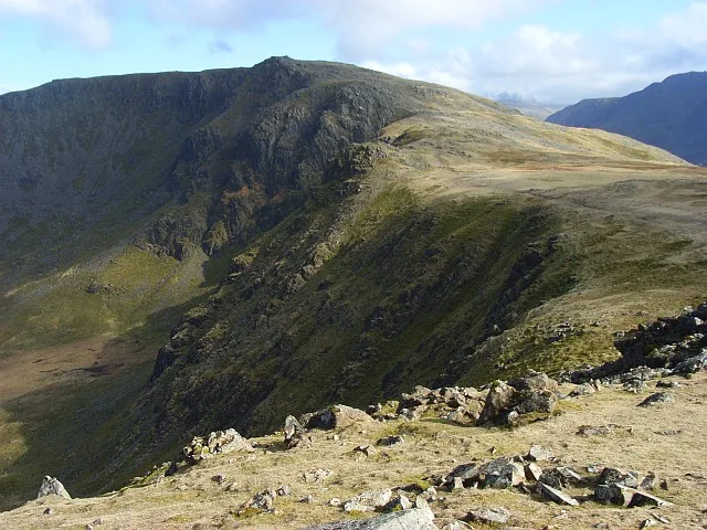
High Stile (summit) — mountain in england north east. Elevation: 806.5 m.

Peter S — CC BY-SA 2.0 via Wikimedia Commons licence
Plan your visit
- Typical visit
- 3 h–8 h
- Best time of year
- Late spring – early autumn (May–Oct)
About
High Stile (summit) is a mountain located in england north east. Elevation: 806.5 m. A named British peak recorded in OpenStreetMap. Peaks are typically named on Ordnance Survey 1:50k mapping.
Photo gallery
Place summary
High Stile is a mountain located in North-East England. It is part of the Helvellyn range and is known for its rugged terrain and sweeping views. The summit offers a challenging ascent for walkers and climbers alike, making it a notable destination for outdoor enthusiasts. The area is characterised by its natural beauty and varied landscapes, typical of the Lake District National Park.
AI-generated from the structured facts on this page (operator, designation, listing, era). Not a substitute for visiting.
- Coordinates
- 54.5218, -3.2837
Sources
- osm: n11831393362 (ODbL)
Other places nearby
Loading nearby places…
Nearby
 📷 3
📷 3Natural landmarks · North East England
High Stile
High Stile — mountain in Lake District, UK.
📷 5Climbing & bouldering crags · North East England
Grey Crag
Grey Crag — a climbing crag in england north east.
 📷 3
📷 3Mountains & hills · North East England
High Stile (Wainwright)
High Stile (Wainwright) — Named summit at 806.2 m.
 📷 5
📷 5Climbing & bouldering crags · North East England
Comb Crag
Comb Crag — a climbing crag in england north east.
 📷 5
📷 5Climbing & bouldering crags · North East England
Eagle Crag
Eagle Crag — a climbing crag in england north east.
📷 5Climbing & bouldering crags · North East England
Comb Crag
Comb Crag — a climbing crag in england north east.
Where to eat & stay near High Stile (summit)
Places to stay
 📷 5
📷 5Campsites · North East England
Dalegarth Guest House Camp Site
Dalegarth Guest House Camp Site — a campsite in england north east.
 📷 5
📷 5Campsites · North East England
Syke Farm Campsite
Syke Farm Campsite — a campsite in england north east.
 📷 5
📷 5Hostels · North East England
Ennerdale
Ennerdale — a hostel in england north east.
 📷 5
📷 5Hostels · North East England
YHA Black Sail
YHA Black Sail — a hostel in england north east.
 📷 5
📷 5Hostels · North East England
Honister Pass YHA
Honister Pass YHA — a hostel in england north east.
 📷 5
📷 5Campsites · North West England
Wasdale Head Campsite
Wasdale Head Campsite — a campsite in england north west.
Places to eat & drink
 📷 5
📷 5Cafés · North East England
Grange Bridge Cottage
Grange Bridge Cottage — a café in england north east.
 📷 5
📷 5Cafés · Scottish Lowlands
YHA Cafe
YHA Cafe — a café in scotland lowlands.
 📷 5
📷 5Historic pubs · Scottish Lowlands
The Pheasant Inn
The Pheasant Inn in Scotland Lowlands, United Kingdom.
 📷 5
📷 5Historic pubs · North West England
The Travellers Rest
The Travellers Rest in England North West, United Kingdom.
 📷 5
📷 5Historic pubs · North West England
Fox and Grapes
Fox and Grapes in England North West, United Kingdom.
 📷 5
📷 5Historic pubs · North West England
Golden Rule Hotel
Golden Rule Hotel in England North West, United Kingdom.
More mountains in this region
 📷 3
📷 3Mountains & hills · North East England
Angletarn Pikes
Angletarn Pikes — Named summit at 566 m.
 📷 3
📷 3Mountains & hills · North East England
Angletarn Pikes South Top
Angletarn Pikes South Top — Named summit at 563.6 m.
 📷 3
📷 3Mountains & hills · North East England
Ard Crags
Ard Crags — Named summit at 581 m.
 📷 3
📷 3Mountains & hills · North East England
Arnison Crag
Arnison Crag — Named summit at 433 m.
Frequently asked questions
- Where is High Stile (summit)?
- High Stile (summit) is in North-East England, United Kingdom.
- What is High Stile (summit)?
- High Stile (summit) — mountain in england north east. Elevation: 806.5 m.
- How do I get to High Stile (summit)?
- Its coordinates are 54.5218°, -3.2837°.