Mountains & hills · Mid Wales
Heath Mynd
In or near Priestweston.
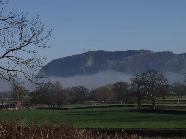
Heath Mynd — Named summit at 452.6 m.

Wikimedia Commons contributors — see linked file page for photographer and licence licence
Plan your visit
- Typical visit
- 3 h–8 h
- Best time of year
- Late spring – early autumn (May–Oct)
- Free entry
- Dog-friendly
About
Heath Mynd is a named summit in the United Kingdom. Wikidata describes it as: "Named summit at 452.6 m.". Coordinates: 52.5406°, -2.9810°.
Photo gallery
Protected designations
- National Nature Reserve: STIPERSTONES LANDSCAPE
- Area of Outstanding Natural Beauty: Shropshire Hills
Designations sourced from Natural England open data under OGL v3.
From the Wikipedia article
Heath Mynd is a hill in the English county of Shropshire. At a height of 452 metres (1,483 ft) it is fairly unnotable except for its Marilyn status, a feature caused by the sharp drop on all sides. It is connected to Corndon Hill by a low col, and is only just inside England, being just one mile from the border with Wales. The nearby village is Norbury; nearest towns are Bishop's Castle and Church Stretton. Its nearest neighbour (visible in the photo) is called Cefn Gunthly.
Excerpt from Wikipedia under CC BY-SA 4.0. See the source article linked in Sources below.
- Coordinates
- 52.5406, -2.9810
- District
- Shropshire
- Parish
- More
- Postcode
- SY15 6AY
- Parliamentary constituency
- South Shropshire
Sources
- osm: n3734048144 (ODbL)
- wikipedia: Heath Mynd (CC BY-SA 4.0)
- commons: Heath Mynd.jpg (CC BY-SA 4.0)
Other places nearby

Cefn Gunthly
Mountains & hills · 0.9 km
Cefn Gunthly
Mountains & hills · 0.9 km

Black Rhadley Hill
Mountains & hills · 1.7 km
Black Rhadley Hill
Mountains & hills · 1.7 km

Runnis Meadow Campsite
Caravan parks · 1.7 km

Linley Mound
Castles · 1.8 km

Roveries Wood
Mountains & hills · 1.8 km

Linley
Castles · 1.8 km

Slight univallate hillfort 600m north of Roveries House
Vineyards · 1.9 km

Roveries Hill Camp
Vineyards · 1.9 km

Linley Hill
Mountains & hills · 2.0 km

Hyssington Castle
Forts · 2.1 km
Nearby
📷 5📷 5📷 5Mountains & hills · Mid Wales
Black Rhadley Hill
Black Rhadley Hill — a hill or mountain in wales mid.
📷 5Mountains & hills · Mid Wales
Black Rhadley Hill
Black Rhadley Hill — mountain in wales mid. Elevation: 401 m.
📷 5Caravan parks · Mid Wales
Runnis Meadow Campsite
Runnis Meadow Campsite — a caravan park in wales mid.
📷 5Where to eat & stay near Heath Mynd
Places to stay
📷 5Caravan parks · Mid Wales
Runnis Meadow Campsite
Runnis Meadow Campsite — a caravan park in wales mid.
 📷 5
📷 5Caravan parks · Mid Wales
Daisy Bank Touring Caravan Park
Daisy Bank Touring Caravan Park — a caravan park in wales mid.
 📷 5
📷 5Campsites · Mid Wales
Foxholes Camp Site
Foxholes Camp Site — a campsite in wales mid.
 📷 5
📷 5 📷 5
📷 5 📷 5
📷 5Places to eat & drink
 📷 5
📷 5Historic pubs · Mid Wales
The Black Lion And Forecourt Railings
The Black Lion And Forecourt Railings in Wales Mid, United Kingdom.
 📷 7
📷 7Historic pubs · Mid Wales
The Six Bells And Former Stables To Rear
The Six Bells And Former Stables To Rear in Wales Mid, United Kingdom.
 📷 7
📷 7 📷 5
📷 5 📷 5
📷 5 📷 4
📷 4Historic pubs · Mid Wales
The Checkers
The Checkers in Wales Mid, United Kingdom.
More mountains in this region
 📷 3
📷 3 📷 3
📷 3 📷 3
📷 3 📷 3
📷 3Frequently asked questions
- Where is Heath Mynd?
- Heath Mynd is in Mid Wales, United Kingdom (postcode SY15 6AY), in the parish of More.
- What is Heath Mynd?
- Heath Mynd — Named summit at 452.6 m.
- How do I get to Heath Mynd?
- Drivers can use postcode SY15 6AY.
- Is Heath Mynd a protected site?
- Yes — Heath Mynd is part of the STIPERSTONES LANDSCAPE National Nature Reserve and the Shropshire Hills National Landscape (AONB).
- Is Heath Mynd free to visit?
- Yes, Heath Mynd is free to enter.
- How do I get to Heath Mynd?
- Drivers can navigate to postcode SY15 6AY. It sits within the South Shropshire parliamentary constituency.