
Historic churches · North East England
Healey
In or near Stocksfield.
Healey in England North East, United Kingdom.

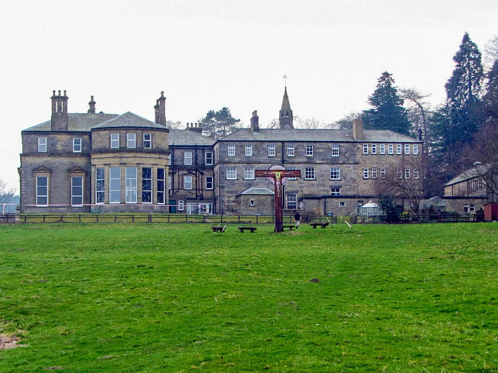
Oliver Dixon — CC BY-SA 2.0 via Wikimedia Commons licence

Plan your visit
- Typical visit
- 30 min–1 h
- Nearest railway station
- Riding Mill · 3.1 km
- Free entry
Getting there & planning your visit
To visit Healey church in Northumberland, the nearest railway station is Riding Mill, located 3.1 km away. Entry to the church is free.
About
Healey is a place of interest in England North East, United Kingdom — drawn from open-data sources for visitor reference. See the linked Wikipedia article for the full description.
Photo gallery
Protected designations
- Area of Outstanding Natural Beauty: North Pennines
Designations sourced from Natural England open data under OGL v3.
From the Wikipedia article
Healey is a rural estate and civil parish in Northumberland, England, situated between Riding Mill to the north and Slaley to the south. The neo-Norman St John's Parish Church, which was built in 1860, was awarded the 2011 Art in a Religious Context award for its windows by Anne Vibeke Mou and James Hugonin. At the 2001 census, the parish had a population of 194, falling slightly to 191 at the 2011 Census. Originally part of the barony of Baliol, Healey was given over to the Knights Templars in the 1260s (hence the area sometimes referred to as Temple Healey). With the suppression of the Templars the land passed to the monarch in 1308 and then shortly after to the Knight Hospitallars. At the dissolution the land returned to the monarch. By the early 1600s the area was held by the Sanderson family. In 1816 the land was sold to Robert Ormston of Newcastle. His son, also called Robert, took down the remains of the peel house and built Healey Hall. A chapel of ease, St John’s, was built in 1860 to designs by Major C.E. Davis of Bath. The west tower was added in 1890. The vicarage was built in 1877 from designs by Ewan Christian.
Excerpt from Wikipedia under CC BY-SA 4.0. See the source article linked in Sources below.
Background
History
--> Originally part of the barony of Baliol, Healey was given over to the Knights Templars in the 1260s (hence the area sometimes referred to as Temple Healey). With the suppression of the Templars the land passed to the monarch in 1308 and then shortly after to the Knight Hospitallars. At the dissolution the land returned to the monarch. By the early 1600s the area was held by the Sanderson family. In 1816 the land was sold to Robert Ormston of Newcastle. His son, also called Robert, took down the remains of the peel house and built Healey Hall. A chapel of ease, St John’s, was built in 1860 to designs by Major C.E. Davis of Bath. The west tower was added in 1890. The vicarage was built in…
Sourced from Wikipedia under CC BY-SA 4.0.
- Coordinates
- 54.9210, -1.9780
- District
- Northumberland
- Parish
- Healey
- Postcode
- NE44 6BJ
- Parliamentary constituency
- Hexham
- Nearest railway station
- Riding Mill — 3.1 km
Sources
- wikidata: Q2999121 (CC0)
- wikipedia: Healey, Northumberland (CC BY-SA 4.0)
Other places nearby

Ridingmill
Villages · 1.6 km

Broomhaugh and Riding Mill War Memorial
Memorials & monuments · 2.8 km

Broomley
Other places · 2.9 km

Wellington Inn
Historic pubs · 3.0 km

Broomhaugh and Riding
Other places · 3.0 km
Riding Mill
Heritage railway stations · 3.0 km
Minsteracres
Abbeys & priories · 3.0 km
Broomhaugh
Other places · 3.0 km

Riding Mill railway station
Heritage railway stations · 3.1 km

Beauclerc
Other places · 3.2 km

Bridge Over Flothers Burn 50 Metres South-East Of Flothers Farmhouse
Historic bridges · 3.2 km

Hindley
Historic houses · 3.5 km
Nearby
📷 5📷 3Memorials & monuments · North East England
Broomhaugh and Riding Mill War Memorial
Broomhaugh and Riding Mill War Memorial — Grade II listed building-listed memorial in scotland-lowlands, United Kingdom.
📷 4📷 5Historic pubs · North East England
Wellington Inn
Wellington Inn in Scotland Lowlands, United Kingdom.
📷 3Other places · North East England
Broomhaugh and Riding
Broomhaugh and Riding in England North East, United Kingdom.
📷 5Heritage railway stations · North East England
Riding Mill
Riding Mill in England North East, United Kingdom.
Where to eat & stay near Healey
Places to stay
 📷 5
📷 5Caravan parks · North East England
Springhouse Caravan Park
Springhouse Caravan Park — a caravan park in scotland lowlands.
 📷 5
📷 5B&Bs · North East England
Duke Of Wellington Inn
Duke Of Wellington Inn — a bed-and-breakfast in scotland lowlands.
 📷 5
📷 5Campsites · North East England
Dilston Scout Camp
Dilston Scout Camp — a campsite in scotland lowlands.
 📷 5
📷 5Caravan parks · North East England
Bolbec Manor Campsite
Bolbec Manor Campsite — a caravan park in scotland lowlands.
 📷 5
📷 5Campsites · North East England
Derwent View
Derwent View — a campsite in scotland lowlands.
📷 5Caravan parks · North East England
Derwent View
Derwent View — a caravan park in scotland lowlands.
Places to eat & drink
📷 5Historic pubs · North East England
Wellington Inn
Wellington Inn in Scotland Lowlands, United Kingdom.
 📷 4
📷 4 📷 5
📷 5Historic pubs · North East England
Travellers' Rest Inn
Travellers' Rest Inn in Scotland Lowlands, United Kingdom.
 📷 7
📷 7Historic pubs · North East England
The Vicars Pele
The Vicars Pele in Scotland Lowlands, United Kingdom.
 📷 5
📷 5Cafés · North East England
The White Monk Tearoom
The White Monk Tearoom — a café in scotland lowlands.
 📷 5
📷 5Historic pubs · North East England
The Lord Crewe Arms Hotel
The Lord Crewe Arms Hotel in Scotland Lowlands, United Kingdom.
More places in this region
 📷 3
📷 3Historic churches · North East England
Church of St Andrew
Church of St Andrew — Grade I listed church in Winston, County Durham, England, UK.
 📷 3
📷 3Historic churches · North East England
Church of St Andrew
Church of St Andrew — Grade I listed church, County Durham, England, UK.
 📷 3
📷 3Historic churches · North East England
Church of St Mary
Church of St Mary — Grade I listed church in Gainford, County Durham, England, UK.
 📷 3
📷 3Historic churches · North East England
Church of St Mary
Church of St Mary — church in Barnard Castle, County Durham, England, UK.
Frequently asked questions
- Where is Healey?
- Healey is in North-East England, United Kingdom (postcode NE44 6BJ), in the parish of Healey.
- What is Healey?
- Healey in England North East, United Kingdom.
- How do I get to Healey?
- The nearest railway station is Riding Mill, about 3.1 km away. Drivers can use postcode NE44 6BJ.
- Is Healey a protected site?
- Yes — Healey is part of the North Pennines National Landscape (AONB).
- Is Healey free to visit?
- Yes, Healey is free to enter.
- How do I get to Healey?
- The nearest railway station is Riding Mill, about 3.1 km away. Drivers can navigate to postcode NE44 6BJ.