
Historic churches · South East England
Halling, Kent
In or near Wouldham.
Halling is a village on the North Downs in the northern part of Kent, England. Consisting of Lower Halling, Upper Halling and North Halling, it is scattered over some 3 miles (5 km) along the River Me

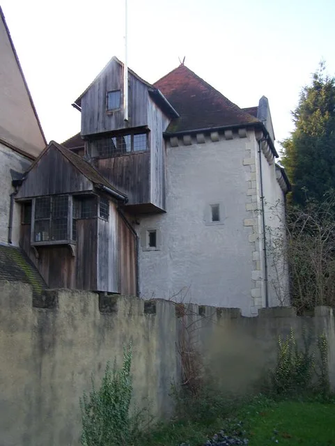
Philip Halling — CC BY-SA 2.0 via Wikimedia Commons licence

Plan your visit
- Typical visit
- 30 min–1 h
- Nearest railway station
- Halling · 0.1 km
- Free entry
Getting there & planning your visit
To visit Halling Church in Kent, the nearest railway station is Halling, located just 0.1 km away. Entry to the church is free.
About
Halling is a village on the North Downs in the northern part of Kent, England. Consisting of Lower Halling, Upper Halling and North Halling, it is scattered over some 3 miles (5 km) along the River Medway parallel to the Pilgrims' Way which runs through Kent. The origin of the name is uncertain. The following have been proposed at various times: Halls land (belonging to Hall), Heall land (from Old English, Hall Manor), Heallgemot (the court of the lord of the Manor) and Heallingas (companions sharing the same hall).
Photo gallery
Protected designations
- Site of Special Scientific Interest: Halling to Trottiscliffe Escarpment SSSI
- National Nature Reserve: NORTH KENT WOODS AND DOWNS
- Area of Outstanding Natural Beauty: Kent Downs
Designations sourced from Natural England open data under OGL v3.
From the Wikipedia article
Halling is a village on the North Downs in the northern part of Kent, England. Consisting of Lower Halling, Upper Halling and North Halling, it is scattered over some 3 miles (5 km) along the River Medway parallel to the Pilgrims' Way which runs through Kent. The origin of the name is uncertain. The following have been proposed at various times: Halls land (belonging to Hall), Heall land (from Old English, Hall Manor), Heallgemot (the court of the lord of the Manor) and Heallingas (companions sharing the same hall).
Excerpt from Wikipedia under CC BY-SA 4.0. See the source article linked in Sources below.
Background
History
"Halling Man", a Neolithic skeleton discovered in 1912 behind the present railway station, is the earliest indication of activity in Halling. There is evidence of Roman settlement indicated by a number of burials from the period as well as Roman tiles. The first written record dates from the 8th century. In the Charter for Halling (765-785 AD), Ecgberht II of Kent granted to St. Andrew of Rochester "ten sulings at Halling with rights to pasture swine in five districts".
Sourced from Wikipedia under CC BY-SA 4.0.
- Coordinates
- 51.3533, 0.4439
- District
- Medway
- Parish
- Halling
- Postcode
- ME2 1AT
- Parliamentary constituency
- Rochester and Strood
- Nearest railway station
- Halling — 0.1 km
- Official site
- www.neighbourhood.statistics.gov.uk
Sources
- wikipedia: Halling, Kent (CC BY-SA 4.0)
Other places nearby

Halling Village Sign
Public art & sculpture · 0.5 km

Bishop's palace at Halling
Palaces · 0.6 km

Wouldham
Towns & cities · 1.1 km
Starkey Castle
Stately homes · 1.6 km

Holborough
Villages · 1.8 km

Church of St Michael and All Angels, Cuxton
Historic churches · 2.1 km

Snodland War Memorial
Memorials & monuments · 2.3 km

Palaeolithic site
Vineyards · 2.3 km

Cuxton
Historic churches · 2.4 km

Wouldham Shoulder of Mutton Wood
Castles · 2.6 km

Snodland railway station
Heritage railway stations · 2.6 km

All Saints Church, Snodland
Historic churches · 2.6 km
Nearby
📷 5Public art & sculpture · South East England
Halling Village Sign
Halling Village Sign — a public art in england-london, United Kingdom.
📷 5Palaces · South East England
Bishop's palace at Halling
Bishop's palace at Halling — a Grade II*-listed palace in england-london, United Kingdom.
📷 5Towns & cities · South East England
Wouldham
Wouldham — village and civil parish in Kent, UK.
Flagship📷 5Stately homes · South East England
Starkey Castle
Starkey Castle — Grade I listed manor house in Wouldham, Kent, England, UK.
📷 5📷 5Historic churches · South East England
Church of St Michael and All Angels, Cuxton
Church of St Michael and All Angels, Cuxton — Grade I listed building-listed church in england-london, United Kingdom.
Where to eat & stay near Halling, Kent
Places to stay
 📷 5
📷 5Campsites · South East England
Buckmore Park Scout Campsite
Buckmore Park Scout Campsite — a campsite in england london. Brand: The Scout Association.
 📷 5
📷 5Campsites · South East England
Badgells Wood Camping
Badgells Wood Camping — a campsite in england london.
 📷 5
📷 5Campsites · South East England
Kits Coty Glamping
Kits Coty Glamping — a campsite in england london.
 📷 5
📷 5Campsites · South East England
Ashmere Farm Certified Campsite
Ashmere Farm Certified Campsite — a campsite in england london.
 📷 5
📷 5 📷 5
📷 5Places to eat & drink
 📷 5
📷 5Historic pubs · South East England
Robin Hood Public House
Robin Hood Public House in England South East, United Kingdom.
 📷 5
📷 5Restaurants · South East England
Frankie & Benny's
Frankie & Benny's — a restaurant in england london. Cuisine: american. Brand: Frankie & Benny's.
 📷 7
📷 7Historic pubs · South East England
The Leather Bottle Inn
The Leather Bottle Inn in England South East, United Kingdom.
 📷 5
📷 5Restaurants · South East England
Kaya Meze Bar
Kaya Meze Bar — a restaurant in england london.
 📷 7
📷 7 📷 5
📷 5More places in this region
 📷 5
📷 5Historic churches · South East England
All Saints Church, Frindsbury
All Saints Church, Frindsbury — church in Medway, UK.
 📷 5
📷 5Historic churches · South East England
All Saints Church, Maidstone
All Saints Church, Maidstone — parish church associated with the Archbishop's Palace, Maidstone, Kent, England, UK.
 📷 5
📷 5Historic churches · South East England
All Saints Church, West Farleigh
All Saints Church, West Farleigh — Grade I listed church in West Farleigh, Maidstone, Kent, England, UK.
 📷 5
📷 5Historic churches · South East England
All Souls' Church, Sutton Green
All Souls' Church, Sutton Green — church in Guildford, England.
Frequently asked questions
- Where is Halling, Kent?
- Halling, Kent is in London, United Kingdom (postcode ME2 1AT), in the parish of Halling.
- What is Halling, Kent?
- Halling is a village on the North Downs in the northern part of Kent, England. Consisting of Lower Halling, Upper Halling and North Halling, it is scattered over some 3 miles (5 km) along the River Me
- How do I get to Halling, Kent?
- The nearest railway station is Halling, about 0.1 km away. Drivers can use postcode ME2 1AT.
- Is Halling, Kent a protected site?
- Yes — Halling, Kent is part of the Halling to Trottiscliffe Escarpment SSSI Site of Special Scientific Interest and the NORTH KENT WOODS AND DOWNS National Nature Reserve.
- Is Halling, Kent free to visit?
- Yes, Halling, Kent is free to enter.
- How do I get to Halling, Kent?
- The nearest railway station is Halling, about 0.1 km away. Drivers can navigate to postcode ME2 1AT.