
Villages · South West England
Hallen
In or near Easter Compton.
Hallen — a village in wales south.

David Smith — CC BY-SA 2.0 via Wikimedia Commons licence

Plan your visit
- Typical visit
- 1 h–2 h
- Nearest railway station
- St Andrews Road · 3.3 km
About
A British village — settlements of this size traditionally cluster a green, parish church, pub and post office around historic land routes.
Photo gallery
See it from the streetimagery from 2022
Imagery © Mapillary contributors, CC BY-SA 4.0
Protected designations
- Site of Special Scientific Interest: Severn Estuary SSSI
- Ramsar wetland: Severn Estuary
Designations sourced from Natural England open data under OGL v3.
Place summary
Hallen is a village located in South Wales, within the parish of Almondsbury and the postcode area BS10. It is notable for its proximity to the Severn Estuary, which is designated as a Site of Special Scientific Interest (SSSI) and is also recognised under the RAMSAR convention. The area is significant for its ecological value, attracting various bird species and supporting diverse habitats.
AI-generated from the structured facts on this page (operator, designation, listing, era). Not a substitute for visiting.
- Coordinates
- 51.5169, -2.6490
- District
- South Gloucestershire
- Parish
- Almondsbury
- Postcode
- BS10 7RP
- Parliamentary constituency
- Thornbury and Yate
- Nearest railway station
- St Andrews Road — 3.3 km
Sources
- manual: geonames-2647620 (CC BY 4.0)
Other places nearby

Hallen War Memorial
Memorials & monuments · 0.0 km

Berwick Lodge
Manor houses · 1.2 km

Blaise Hamlet
Castles · 1.4 km

Guard Dog
Public art & sculpture · 1.6 km

Blaise Inn Public House
Historic pubs · 1.6 km

Henbury Lodge Hotel
Hotels · 1.6 km

Henbury Village Hall
Historic houses · 1.7 km
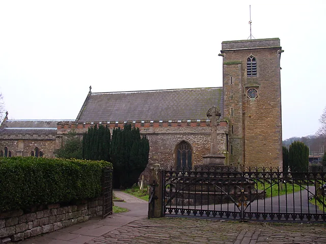
St Mary's Church, Henbury
Historic churches · 1.7 km

Blaise Castle House Museum
Museums · 1.7 km

Henbury War Memorial
Memorials & monuments · 1.7 km
Scipio Africanus
Memorials & monuments · 1.7 km

Amelia Ann Blanford Edwards
Memorials & monuments · 1.7 km
Nearby
📷 3Memorials & monuments · South West England
Hallen War Memorial
Hallen War Memorial — Grade II listed building-listed memorial in wales-south, United Kingdom.
📷 3Manor houses · South West England
Berwick Lodge
Berwick Lodge — a manor in wales-south, United Kingdom.
📷 5Castles · South West England
Blaise Hamlet
Blaise Hamlet is a group of nine small cottages around a green in Henbury, now a district in the north of Bristol, England. All the cottages, and the sundial on the green, are Grade I listed buildings
📷 5Public art & sculpture · South West England
Guard Dog
Guard Dog — a public art in wales-south, United Kingdom.
📷 7Historic pubs · South West England
Blaise Inn Public House
Blaise Inn Public House in Wales South, United Kingdom.
📷 5Where to eat & stay near Hallen
Places to stay
📷 5 📷 5
📷 5Campsites · South West England
Brockmead Scout Camp Site
Brockmead Scout Camp Site — a campsite in wales south.
 📷 5
📷 5 📷 7
📷 7 📷 5
📷 5Campsites · South West England
The Wave Campsite
The Wave Campsite — a campsite in wales south.
 📷 5
📷 5Caravan parks · South West England
Vine Farm Caravan Park
Vine Farm Caravan Park — a caravan park in wales south.
Places to eat & drink
📷 7Historic pubs · South West England
Blaise Inn Public House
Blaise Inn Public House in Wales South, United Kingdom.
 📷 5
📷 5Historic pubs · South Wales
The Lamplighters Public House
The Lamplighters Public House in Wales South, United Kingdom.

 📷 7
📷 7 📷 5
📷 5Historic pubs · South West England
Clifton Down railway station
Clifton Down railway station in Wales South, United Kingdom.
 📷 5
📷 5More places in this region
 📷 5
📷 5 📷 5
📷 5 📷 5
📷 5 📷 5
📷 5Frequently asked questions
- Where is Hallen?
- Hallen is in South Wales, United Kingdom (postcode BS10 7RP), in the parish of Almondsbury.
- What is Hallen?
- Hallen — a village in wales south.
- How do I get to Hallen?
- The nearest railway station is St Andrews Road, about 3.3 km away. Drivers can use postcode BS10 7RP.
- Is Hallen a protected site?
- Yes — Hallen is part of the Severn Estuary SSSI Site of Special Scientific Interest and the Severn Estuary Ramsar wetland.
- How do I get to Hallen?
- The nearest railway station is St Andrews Road, about 3.3 km away. Drivers can navigate to postcode BS10 7RP.