
Archaeological sites · Mid Wales
Hafren Forest
Also known as: Coedwig Hafren
In or near Llanidloes.
Hafren Forest is a archaeological site in the United Kingdom.

Wikimedia Commons licence
Plan your visit
- Typical visit
- 45 min–1.5 h
- Free entry
- Dog-friendly
About
Hafren Forest is an archaeological site in the United Kingdom. Coordinates: 52.4788°, -3.6917°. This entry is part of The Great Britain Guide, a free, ad-free, open-data tourist directory.
Photo gallery
From the Wikipedia article
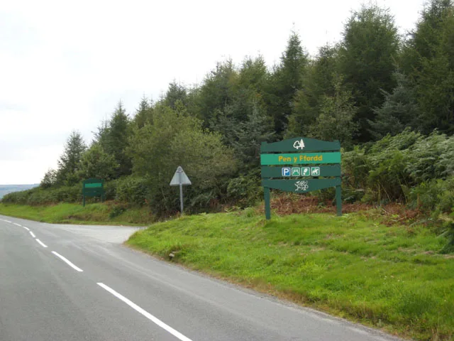
Hafren Forest (Welsh: Coedwig Hafren) is a wooded area north-west of the ancient market town of Llanidloes, Mid Wales. The forest covers around 40 square kilometres (15 square miles), and consists mainly of pine and spruce trees. It takes its name from the Afon Hafren (Welsh for 'River Severn') which rises in a deep peat bog approximately 800 metres (0.5 miles) outside western boundary of the forest, high on the slopes of Pumlumon, the highest mountain in Mid Wales.
Excerpt from Wikipedia under CC BY-SA 4.0. See the source article linked in Sources below.
Background
History
The forest, planted in 1937, is continually changing with felling and planting of trees. The forest is also home to Bronze Age copper and lead mines, most notably "Nant yr Eira" and possibly "Nant yr Rickett". The creation of the forest in 1937 involved the purchase of twelve upland sheep farms, including "Rhyd y Benwch" which is now the location of a car park and picnic area. Although the farms were not left derelict, they could not provide enough accommodation for forest workers in this sparsely populated area. At first, with the initial small size of the forest, enough workers could be found locally. Later, workers were transported from Llanidloes. This was unsustainable, and in 1948,…
Visiting
Although the forest still produces timber for Natural Resources Wales, it has also developed as a wildlife habitat and as a tourist attraction. The red kite is seen in the area, along with many other birds, plants and animals. There are numerous footpaths, and many bridleways that are popular for mountain biking and horse riding. Published walks include "The Source of The Severn", "Severn Breaks its Neck" and "The Blaenhafren Falls". The Wye Valley Walk finishes at Rhyd y Benwch in the forest. A quarry in the forest is used for "explosion studies" by Aberystwyth University's Combustion Physics Group. This quarry had previously been used by British Aerospace.
Sourced from Wikipedia under CC BY-SA 4.0.
- Coordinates
- 52.4788, -3.6917
Sources
- wikidata: Q5638420 (CC0)
- wikipedia: Hafren Forest (CC BY-SA 4.0)
Other places nearby

Cwm y Derw
Mountains & hills · 1.4 km

Llechwedd y Glyn
Mountains & hills · 1.5 km

Blaen Hafren
Waterfalls · 1.7 km

Hafren-Torri-Gwddf
Waterfalls · 1.8 km

Mynydd Y Groes
Mountains & hills · 2.0 km
Gias
Mountains & hills · 2.2 km

Pumlumon Cwmbiga
Mountains & hills · 2.3 km

Carreg Wen
Archaeological sites · 2.3 km
Gïas
Mountains & hills · 2.3 km

Esgair y Maesnant NW Top
Mountains & hills · 2.7 km

Esgair y Maesnant SE Top
Mountains & hills · 2.7 km

Esgair Gronwen
Mountains & hills · 2.7 km
Nearby
📷 3Mountains & hills · Mid Wales
Cwm y Derw
Cwm y Derw — a mountain in wales-mid, United Kingdom, 510 m.
📷 3Mountains & hills · Mid Wales
Llechwedd y Glyn
Llechwedd y Glyn — a mountain in wales-mid, United Kingdom, 481 m.
📷 5📷 5📷 5Mountains & hills · Mid Wales
Mynydd Y Groes
Mynydd Y Groes — mountain in wales mid. Elevation: 480 m.
📷 5Where to eat & stay near Hafren Forest
Places to stay
 📷 5
📷 5 📷 5
📷 5 📷 5
📷 5Caravan parks · Mid Wales
Glangwy Farm Camping
Glangwy Farm Camping — a caravan park in wales mid.
 📷 5
📷 5 📷 5
📷 5Caravan parks · Mid Wales
Clywedog Riverside Holiday Home Park
Clywedog Riverside Holiday Home Park — a caravan park in wales mid.
 📷 5
📷 5Campsites · Mid Wales
Dol Llys Farm Caravan and Camping
Dol Llys Farm Caravan and Camping — a campsite in wales mid.
Places to eat & drink
 📷 5
📷 5Cafés · Mid Wales
Llywernog Silver Lead Mine
Llywernog Silver Lead Mine — a café in wales mid.
 📷 5
📷 5Restaurants · Mid Wales
The White Lion Hotel
The White Lion Hotel — a restaurant in wales mid.
 📷 6
📷 6 📷 7
📷 7 📷 5
📷 5More archaeological sites in this region
 📷 5
📷 5 📷 3
📷 3Archaeological sites · Mid Wales
Quaker settlement Dolgellau
Quaker settlement Dolgellau — a archaeological in wales-north, United Kingdom.
 📷 3
📷 3Archaeological sites · Mid Wales
Centenary Viewpoint
Centenary Viewpoint — a archaeological in wales-north, United Kingdom.
 📷 3
📷 3Archaeological sites · Mid Wales
Gwanas-Fawr Roman Marching Camp
Gwanas-Fawr Roman Marching Camp — a archaeological in wales-north, United Kingdom.
Frequently asked questions
- Where is Hafren Forest?
- Hafren Forest is in Mid Wales, United Kingdom.
- What is Hafren Forest?
- Hafren Forest is a archaeological site in the United Kingdom.
- How do I get to Hafren Forest?
- Its coordinates are 52.4788°, -3.6917°.
- Is Hafren Forest free to visit?
- Yes, Hafren Forest is free to enter.