
Memorials & monuments · South West England
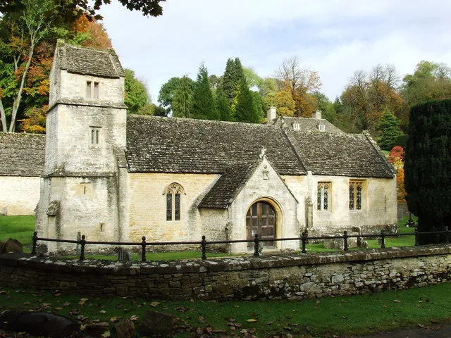
Group of 35 17th to 18th century monuments in the churchyard of the Church of All Saints, west of the path to Church Cottage as far as the Henry Baldwin Monument
In or near Duntisbourne Abbots.
Group of 35 17th to 18th century monuments in the churchyard of the Church of All Saints, west of the path to Church Cottage as far as the Henry Baldwin Monument — Grade II listed building-listed memo

John Salmon — CC BY-SA 2.0 via Wikimedia Commons licence

Plan your visit
- Typical visit
- 15 min–45 min
- Paid entry
- Dog-friendly
About
Group of 35 17th to 18th century monuments in the churchyard of the Church of All Saints, west of the path to Church Cottage as far as the Henry Baldwin Monument is a Grade II listed building-listed memorial in england-west-midlands, United Kingdom, registered on the National Heritage List for England (NHLE entry 1090188). Listed status protects buildings and structures of special architectural or historic interest. See the linked Wikipedia article for further details.
Photo gallery
See it from the streetimagery from 2019
Imagery © Mapillary contributors, CC BY-SA 4.0
Heritage listing
Details NORTH CERNEY NORTH CERNEY VILLAGE SP01 075 - 02 075 16/214 Group of 35 C17-C18 monuments in the churchyard of the Church of All Saints, west of the path to Church Cottage as far as the Henry Baldwin monument GV II Group of 5 chest tombs and 30 headstones (some associated with flat stone slabs and footstones). Limestone. a) Chest tomb with lyre-shaped ends, c3m south of the porch to William Cherington, died 1696 and Sarah Cherington, died 1760. Moulded plinth with oval inscription panel to William Cherington surrounded by finely executed foliate scrollwork on the north side; foliate decoration to the sides of the lyre- shaped ends. Plain rectangular inscription panel to Sarah Cherington on the south side flanked by rectangular slabs decorated with representations of circular vases of flowers in relief; foliate decoration to the sides of the lyre-shaped ends. Cherub's head above a small cartouche at the east end; two cornucopias below the cartouche. Cherub's head and cartouche at the west end. Thick capping with moulded margin. Three flat stone slabs one with headstone and footstone, one with a headstone immediately to the south of the last. b) Chest tomb to Richard Jordan, died 1669 immediately to the south of the flat stone slabs. Flat-chamfered plinth; illegible inscription panel on the north side. Inscription to Richard Jordan on the south side. Thick capping with flat- chamfered margin. c) Chest tomb c0.5m west of the last to members of the Stephens family of Woodmancote. Late C18. Moulded plinth, raised sunken inscription panels on the north and south sides, sunken inscription panels at the ends. Capping with moulded margin and moulded and hipped upper capping stone. Thirty late C17-early, mid and late C18 headstones, between the last and the Henry Baldwin c
From the Historic England List Entry under OGL v3.
Official information
Cerney House Gardens is a picturesque garden featuring a variety of plants and wildlife across 40 acres of Cotswold parkland. Visitors can explore a working organic kitchen garden and enjoy scenic woodland walks. The garden offers seasonal displays of flowers and plants throughout the year.
Protected designations
- Area of Outstanding Natural Beauty: Cotswolds
Designations sourced from Natural England open data under OGL v3.
Place summary
The Group of 35 17th to 18th century monuments is located in the churchyard of the Church of All Saints in North Cerney, Gloucestershire. This collection is designated as a Grade II listed building, reflecting its historical significance. The monuments extend west of the path to Church Cottage, reaching as far as the Henry Baldwin Monument.
AI-generated from the structured facts on this page (operator, designation, listing, era). Not a substitute for visiting.
- Coordinates
- 51.7686, -1.9747
- County
- Gloucestershire
- District
- Cotswold
- Parish
- North Cerney
- Postcode
- GL7 7BX
- Parliamentary constituency
- North Cotswolds
- Official site
- www.cerneygardens.com
Sources
- wikidata: Q26382584 (CC0)
Other places nearby
Row of 3 monuments in the churchyard of the Church of All Saints circa 6 and 1/2 metres south east of the chancel
Memorials & monuments · 0.0 km

Cerney House
Manor houses · 0.3 km

Cerney House Gardens
Gardens · 0.3 km

North Cerney
Villages · 0.5 km

Scrubditch
Archaeological sites · 0.8 km

Bridge at the southern end of the former lake in the grounds of Rendcomb College
Historic bridges · 1.1 km

Perrott's Brook dykes
Vineyards · 1.3 km

Bagendon War Memorial
Memorials & monuments · 1.3 km
Church of St Margaret
Historic churches · 1.3 km

Bridge Over River Churn
Historic bridges · 1.7 km

The Bear
Historic pubs · 1.8 km

Church of St Peter
Historic churches · 2.0 km
Nearby
📷 3Memorials & monuments · South West England
Row of 3 monuments in the churchyard of the Church of All Saints circa 6 and 1/2 metres south east of the chancel
Row of 3 monuments in the churchyard of the Church of All Saints circa 6 and 1/2 metres south east of the chancel — Grade II listed building-listed memorial in england-west-midlands, United Kingdom.
📷 3Manor houses · South West England
Cerney House
Cerney House — a manor in england-west-midlands, United Kingdom.
📷 3Gardens · South West England
Cerney House Gardens
Cerney House Gardens — a garden in england-west-midlands, United Kingdom.
📷 5Archaeological sites · South West England
Scrubditch
Scrubditch — a archaeological in england-west-midlands, United Kingdom.
📷 3Historic bridges · South West England
Bridge at the southern end of the former lake in the grounds of Rendcomb College
Bridge at the southern end of the former lake in the grounds of Rendcomb College — Grade II listed building-listed bridge in england-west-midlands, United Kingdom.
Where to eat & stay near Group of 35 17th to 18th century monuments in the churchyard of the Church of All Saints, west of the path to Church Cottage as far as the Henry Baldwin Monument
Places to stay
 📷 5
📷 5Campsites · South West England
Mayfield Park Touring & Camping
Mayfield Park Touring & Camping — a campsite in england west midlands.
 📷 5
📷 5Hotels · South West England
Stratton House Hotel
Stratton House Hotel — a hotel in england west midlands.
 📷 5
📷 5Campsites · South West England
Green Field Family Campsite
Green Field Family Campsite — a campsite in england west midlands.
 📷 5
📷 5Hotels · South West England
The Corinium Hotel And Restaurant
The Corinium Hotel And Restaurant — a hotel in england west midlands.
 📷 5
📷 5Caravan parks · South West England
Denfurlong Farm
Denfurlong Farm — a caravan park in england west midlands.
 📷 5
📷 5Campsites · South West England
The T Barn
The T Barn — a campsite in england west midlands.
Places to eat & drink
📷 5 📷 5
📷 5Historic pubs · South West England
Five Mile House
Five Mile House in England South East, United Kingdom.
 📷 7
📷 7Historic pubs · South West England
The Nelson Inn
The Nelson Inn in England South East, United Kingdom.
.jpg?width=1200) 📷 3
📷 3Historic pubs · South West England
The 7 Tuns
The 7 Tuns — Historic pub — listed building or notable heritage status.
 📷 7
📷 7Historic pubs · South West England
Colesbourne Inn
Colesbourne Inn in England South East, United Kingdom.
 📷 5
📷 5Historic pubs · South West England
Golden Farm Public House
Golden Farm Public House in England South East, United Kingdom.
More memorials in this region
 📷 5
📷 5Memorials & monuments · South West England
Bath Cenotaph
Bath Cenotaph is a memorial in the United Kingdom.
 📷 5
📷 5Memorials & monuments · South West England
Cross of Sacrifice
Cross of Sacrifice is a memorial in the United Kingdom.
 📷 5
📷 5Memorials & monuments · South West England
Grange Arch
Grange Arch is a memorial in the United Kingdom.
.jpg?width=1200) 📷 5
📷 5Memorials & monuments · South West England
King Alfred Memorial
King Alfred Memorial is a memorial in the United Kingdom.
Frequently asked questions
- Where is Group of 35 17th to 18th century monuments in the churchyard of the Church of All Saints, west of the path to Church Cottage as far as the Henry Baldwin Monument?
- Group of 35 17th to 18th century monuments in the churchyard of the Church of All Saints, west of the path to Church Cottage as far as the Henry Baldwin Monument is in Gloucestershire, the West Midlands, United Kingdom (postcode GL7 7BX), in the parish of North Cerney.
- What is Group of 35 17th to 18th century monuments in the churchyard of the Church of All Saints, west of the path to Church Cottage as far as the Henry Baldwin Monument?
- Group of 35 17th to 18th century monuments in the churchyard of the Church of All Saints, west of the path to Church Cottage as far as the Henry Baldwin Monument — Grade II listed building-listed memo
- How do I get to Group of 35 17th to 18th century monuments in the churchyard of the Church of All Saints, west of the path to Church Cottage as far as the Henry Baldwin Monument?
- Drivers can use postcode GL7 7BX.
- Is Group of 35 17th to 18th century monuments in the churchyard of the Church of All Saints, west of the path to Church Cottage as far as the Henry Baldwin Monument a listed building?
- Group of 35 17th to 18th century monuments in the churchyard of the Church of All Saints, west of the path to Church Cottage as far as the Henry Baldwin Monument is officially recognised as Grade II listed building listed.
- Is Group of 35 17th to 18th century monuments in the churchyard of the Church of All Saints, west of the path to Church Cottage as far as the Henry Baldwin Monument a protected site?
- Yes — Group of 35 17th to 18th century monuments in the churchyard of the Church of All Saints, west of the path to Church Cottage as far as the Henry Baldwin Monument is part of the Cotswolds National Landscape (AONB).
- Is Group of 35 17th to 18th century monuments in the churchyard of the Church of All Saints, west of the path to Church Cottage as far as the Henry Baldwin Monument free to visit?
- Yes, Group of 35 17th to 18th century monuments in the churchyard of the Church of All Saints, west of the path to Church Cottage as far as the Henry Baldwin Monument is free to enter.
- How do I get to Group of 35 17th to 18th century monuments in the churchyard of the Church of All Saints, west of the path to Church Cottage as far as the Henry Baldwin Monument?
- Drivers can navigate to postcode GL7 7BX. It sits within the North Cotswolds parliamentary constituency.