
Historic bridges · South East England
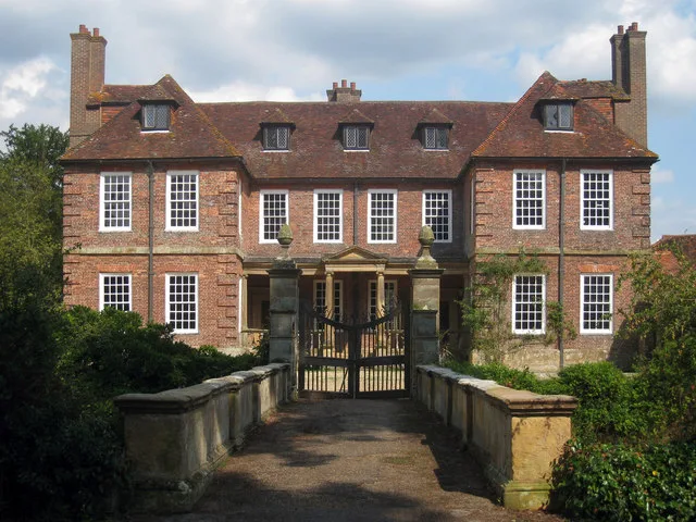
Groombridge Place Moat, Walls and Bridge including the West Gateway and Cottage on the North Bridge
In or near Stone Cross.
Groombridge Place Moat, Walls and Bridge including the West Gateway and Cottage on the North Bridge — Grade I listed building-listed bridge in england-south-east, United Kingdom.

Marathon — CC BY-SA 2.0 via Wikimedia Commons licence

Plan your visit
- Typical visit
- 15 min–30 min
- Nearest railway station
- Groombridge · 0.6 km
- Free entry
- Dog-friendly
Getting there & planning your visit
Groombridge Place Moat, Walls and Bridge is located in Tunbridge Wells, Kent, with the postcode TN3 9QG. The nearest railway station is Groombridge, which is 0.6 km away. Entry is free.
About
Groombridge Place Moat, Walls and Bridge including the West Gateway and Cottage on the North Bridge is a Grade I listed building-listed bridge in england-south-east, United Kingdom, registered on the National Heritage List for England (NHLE entry 1260960). Listed status protects buildings and structures of special architectural or historic interest. See the linked Wikipedia article for further details.
Photo gallery
Heritage listing
Details TQ 53 37 SPELDHURST GROOMBRIDGE HILL (off east side), OLD GROOMBRIDGE 16/505 Groombridge Place moat, walls and bridge including the west 20.10.54 gateway and cottage on the north bridge GV I Moat walls, bridges, west gateway and north bridge cottage. The moat walls. Medieval origins, renovated and probably much rebuilt circa 1660 when Groombridge Place (q.v.) was rebuilt. English bond brick on coursed sandstone blocks. Walls rise a short distance as a parapet and have weathered sandstone coping. West Bridge and Gateway. Circa 1660. Bridge is red brick with sandstone ashlar voussoirs and parapet. Sandstone ashlar gate piers. This is the main entrance across the moat. Single span bridge with a segmental arch. Ashlar parapet walls broken by a series of piers giving a panelled effect. Projecting coping. Gate piers on inside (eastern) end. Tall square section piers with soffit-moulded caps and pineapple vase finials. Double gates are probably original; timber frame with iron spear headed rails. Small attachments onto the bridge containing niche-like seats. East Bridge. Circa 1660. Sandstone ashlar bridge giving access across the moat to the service courtyard. Single span elliptical arch. Plain parapet with weathered coping rising in a ramp from the outer retaining wall. North Bridge and Cottage. Second half of C17. Red brick bridge of 3 uneven arches. The cottage of English bond red brick with similar stack and chimneyshaft and peg-tile roof is built over the inner (southern) 2 arches. The bridge outer elliptical arch is the widest. The other 2 are low pitch pointed arches. The centre one is the smallest and is blind; appears only on the west side. 2-room cottage on the eastern side of the bridge. Outer room is parallel to the bridge with an outer lateral stack and i
From the Historic England List Entry under OGL v3.
Protected designations
- Area of Outstanding Natural Beauty: High Weald
- Area of Outstanding Natural Beauty: Kent Downs
Designations sourced from Natural England open data under OGL v3.
Place summary
Groombridge Place Moat, Walls and Bridge, including the West Gateway and Cottage on the North Bridge, is located in Speldhurst, Kent, South-East England. This site is a Grade I listed building, recognised for its exceptional architectural and historical significance.
AI-generated from the structured facts on this page (operator, designation, listing, era). Not a substitute for visiting.
- Coordinates
- 51.1174, 0.1879
- County
- Kent
- District
- Tunbridge Wells
- Parish
- Speldhurst
- Postcode
- TN3 9QG
- Parliamentary constituency
- Tunbridge Wells
- Nearest railway station
- Groombridge — 0.6 km
Sources
- wikidata: Q96179713 (CC0)
Other places nearby
Groombridge Place
Stately homes · 0.1 km

Buildings Of The Service Courtyard Adjoining South Of Groombridge Place Including The Walls Of The Herb Garden
Historic bridges · 0.1 km
.jpg?width=1200)
Chapel Of St John The Evangelist
Chapels · 0.2 km
.jpg?width=1200)
Mill House
Historic houses · 0.2 km

Bridge At Tq 5305 3756
Historic bridges · 0.2 km

Groombridge
Villages · 0.4 km

Stone Cross
Towns & cities · 1.7 km

Adamswell Scout Camp
Campsites · 1.7 km

Manor Court Farm
Campsites · 1.8 km

Fernchase Manor
Manor houses · 1.8 km

Langton Green War Memorial
Memorials & monuments · 1.8 km

Wealdway
Military museums · 1.9 km
Nearby
Flagship📷 10Stately homes · South East England
Groombridge Place
Groombridge Place — manor house in Speldhurst, Kent, England, UK.
📷 5Historic bridges · South East England
Buildings Of The Service Courtyard Adjoining South Of Groombridge Place Including The Walls Of The Herb Garden
Buildings Of The Service Courtyard Adjoining South Of Groombridge Place Including The Walls Of The Herb Garden — a Grade I-listed bridge in england-south-east, United Kingdom.
📷 5Chapels · South East England
Chapel Of St John The Evangelist
Chapel Of St John The Evangelist — Grade I listed chapel in Tunbridge Wells, United Kingdom.
📷 5📷 5Historic bridges · South East England
Bridge At Tq 5305 3756
Bridge At Tq 5305 3756 — Grade II listed building-listed bridge in england-south-east, United Kingdom.
📷 5Where to eat & stay near Groombridge Place Moat, Walls and Bridge including the West Gateway and Cottage on the North Bridge
Places to stay
📷 5Campsites · South East England
Adamswell Scout Camp
Adamswell Scout Camp — a campsite in england south east.
📷 5 📷 5
📷 5 📷 7
📷 7Hotels · South East England
The Spa Hotel
The Spa Hotel — a hotel in england south east.
 📷 5
📷 5 📷 5
📷 5Hotels · South East England
The Royal Wells Hotel
The Royal Wells Hotel — a hotel in england south east.
Places to eat & drink
.jpg?width=1200) 📷 5
📷 5Historic pubs · South East England
Nevill Crest and Gun
Nevill Crest and Gun — Historic pub — listed building or notable heritage status.
 📷 7
📷 7Historic pubs · South East England
The George And Dragon
The George And Dragon in England South East, United Kingdom.
 📷 7
📷 7Historic pubs · South East England
5-11, Langton Road
5-11, Langton Road in England South East, United Kingdom.
 📷 5
📷 5Historic pubs · South East England
The Spotted Dog Public House
The Spotted Dog Public House in England South East, United Kingdom.
 📷 5
📷 5Historic pubs · South East England
The Sussex Arms Public House
The Sussex Arms Public House in England South East, United Kingdom.
 📷 5
📷 5Historic pubs · South East England
The Boars Head Inn
The Boars Head Inn in England South East, United Kingdom.
More bridges in this region
 📷 5
📷 5Historic bridges · South East England
Briary Hill Bridge east
Briary Hill Bridge east is a historic bridge in the United Kingdom.
 📷 5
📷 5Historic bridges · South East England
Briary Hill Bridge west
Briary Hill Bridge west is a historic bridge in the United Kingdom.
 📷 5
📷 5Historic bridges · South East England
Bridge 157 VIR (Bath Hard Road)
Bridge 157 VIR (Bath Hard Road) is a historic bridge in the United Kingdom.
 📷 5
📷 5Historic bridges · South East England
Dorking Arch Bridge
Dorking Arch Bridge is a historic bridge in the United Kingdom.
Frequently asked questions
- Where is Groombridge Place Moat, Walls and Bridge including the West Gateway and Cottage on the North Bridge?
- Groombridge Place Moat, Walls and Bridge including the West Gateway and Cottage on the North Bridge is in Kent, South-East England, United Kingdom (postcode TN3 9QG), in the parish of Speldhurst.
- What is Groombridge Place Moat, Walls and Bridge including the West Gateway and Cottage on the North Bridge?
- Groombridge Place Moat, Walls and Bridge including the West Gateway and Cottage on the North Bridge — Grade I listed building-listed bridge in england-south-east, United Kingdom.
- How do I get to Groombridge Place Moat, Walls and Bridge including the West Gateway and Cottage on the North Bridge?
- The nearest railway station is Groombridge, about 0.6 km away. Drivers can use postcode TN3 9QG.
- Is Groombridge Place Moat, Walls and Bridge including the West Gateway and Cottage on the North Bridge a listed building?
- Groombridge Place Moat, Walls and Bridge including the West Gateway and Cottage on the North Bridge is officially recognised as Grade I listed building listed.
- Is Groombridge Place Moat, Walls and Bridge including the West Gateway and Cottage on the North Bridge a protected site?
- Yes — Groombridge Place Moat, Walls and Bridge including the West Gateway and Cottage on the North Bridge is part of the High Weald National Landscape (AONB) and the Kent Downs National Landscape (AONB).
- Is Groombridge Place Moat, Walls and Bridge including the West Gateway and Cottage on the North Bridge free to visit?
- Yes, Groombridge Place Moat, Walls and Bridge including the West Gateway and Cottage on the North Bridge is free to enter.
- How do I get to Groombridge Place Moat, Walls and Bridge including the West Gateway and Cottage on the North Bridge?
- The nearest railway station is Groombridge, about 0.6 km away. Drivers can navigate to postcode TN3 9QG.