
Mountains & hills · South East England
Great Litchfield Down
In or near Ecchinswell.
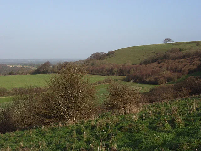
Great Litchfield Down — mountain in england south east. Elevation: 190 m.

Oswald Bertram — CC BY-SA 2.0 via Wikimedia Commons licence

Plan your visit
- Typical visit
- 3 h–8 h
- Best time of year
- Late spring – early autumn (May–Oct)
- Nearest railway station
- Overton · 6.6 km
- Dog-friendly
About
Great Litchfield Down is a mountain located in england south east. Elevation: 190 m. A named British peak recorded in OpenStreetMap. Peaks are typically named on Ordnance Survey 1:50k mapping.
Photo gallery
Protected designations
- Area of Outstanding Natural Beauty: North Wessex Downs
Designations sourced from Natural England open data under OGL v3.
Place summary
Great Litchfield Down is a mountain located in South-East England. This prominent feature offers expansive views of the surrounding landscape. The area is suitable for various outdoor activities, including hiking and nature walks, making it an accessible destination for those seeking to explore the natural terrain. Visitors can expect a mix of challenging and moderate trails that cater to different skill levels.
AI-generated from the structured facts on this page (operator, designation, listing, era). Not a substitute for visiting.
- Coordinates
- 51.2966, -1.3260
- County
- Hampshire
- District
- Basingstoke and Deane
- Parish
- Litchfield and Woodcott
- Postcode
- RG28 7PS
- Parliamentary constituency
- North West Hampshire
- Nearest railway station
- Overton — 6.6 km
Sources
- osm: n10226257100 (ODbL)
Other places nearby

Site of Bowl Barrow
Burial mounds & barrows · 0.8 km

Geoffrey de Havilland Memorial
Memorials & monuments · 1.0 km
Rectangular Enclosure
Archaeological sites · 1.0 km
Rectangular Earthwork
Archaeological sites · 1.1 km

Linear Earthwork
Archaeological sites · 1.2 km
Ladle Hill
Mountains & hills · 1.5 km

An unfinished hillfort, a saucer barrow, a disc barrow and sections of two linear earthworks on Ladle Hill
Vineyards · 1.5 km

Ladle Hill Iron Age Fort
Archaeological sites · 1.6 km

Thorn Down
Mountains & hills · 1.7 km

Litchfield
Villages · 1.9 km

Beacon Hill
Mountains & hills · 2.2 km

Beacon Hill
Viewpoints · 2.2 km
Nearby
📷 5Burial mounds & barrows · South East England
Site of Bowl Barrow
Site of Bowl Barrow — a burial mound in england-south-east, United Kingdom.
📷 5Memorials & monuments · South East England
Geoffrey de Havilland Memorial
Geoffrey de Havilland Memorial — a memorial in england-south-east, United Kingdom.
📷 5Archaeological sites · South East England
Rectangular Enclosure
Rectangular Enclosure — a archaeological in england-south-east, United Kingdom.
📷 5Archaeological sites · South East England
Rectangular Earthwork
Rectangular Earthwork — a archaeological in england-south-east, United Kingdom.
📷 5Archaeological sites · South East England
Linear Earthwork
Linear Earthwork — a archaeological in england-south-east, United Kingdom.
📷 5Where to eat & stay near Great Litchfield Down
Places to stay
 📷 5
📷 5Caravan parks · South East England
Walkeridge Farm
Walkeridge Farm — a caravan park in england south east.
 📷 5
📷 5 📷 5
📷 5Campsites · South East England
Spring Hill Wild Camping
Spring Hill Wild Camping — a campsite in england south east.
 📷 7
📷 7Hotels · South East England
White Hart
White Hart — a hotel in england south east.
 📷 5
📷 5Campsites · South East England
Oakley Farm Caravan Park
Oakley Farm Caravan Park — a campsite in england south east.
 📷 5
📷 5Places to eat & drink
 📷 7
📷 7Historic pubs · South East England
The Carnarvon Arms Public House
The Carnarvon Arms Public House in England South East, United Kingdom.
 📷 7
📷 7Historic pubs · South East England
George And Horne Public House
George And Horne Public House in England South East, United Kingdom.
 📷 7
📷 7Historic pubs · South East England
The Red House Public House
The Red House Public House in England South East, United Kingdom.
 📷 7
📷 7Historic pubs · South East England
The Kings Arms Public House
The Kings Arms Public House in England South East, United Kingdom.
 📷 7
📷 7Historic pubs · South East England
Wellington Arms Public House
Wellington Arms Public House in England South East, United Kingdom.
 📷 7
📷 7Historic pubs · South East England
The Eight Bells
The Eight Bells in England South East, United Kingdom.
More mountains in this region
 📷 5
📷 5 📷 5
📷 5Mountains & hills · South East England
Reigate Caves
Reigate Caves is a mountain or hill in the United Kingdom.
 📷 5
📷 5Mountains & hills · South East England
North Downs
North Downs — a hill or mountain in england london.
 📷 5
📷 5Mountains & hills · South East England
Blue Bell Hill
Blue Bell Hill — a hill or mountain in england london.
Frequently asked questions
- Where is Great Litchfield Down?
- Great Litchfield Down is in Hampshire, South-East England, United Kingdom (postcode RG28 7PS), in the parish of Litchfield and Woodcott.
- What is Great Litchfield Down?
- Great Litchfield Down — mountain in england south east. Elevation: 190 m.
- How do I get to Great Litchfield Down?
- The nearest railway station is Overton, about 6.6 km away. Drivers can use postcode RG28 7PS.
- Is Great Litchfield Down a protected site?
- Yes — Great Litchfield Down is part of the North Wessex Downs National Landscape (AONB).
- How do I get to Great Litchfield Down?
- The nearest railway station is Overton, about 6.6 km away. Drivers can navigate to postcode RG28 7PS.