Other places · North East England
Gilling East Wapentake
In or near Streetlam.
Gilling East Wapentake in England North East, United Kingdom.

Wikimedia Commons licence
Plan your visit
- Typical visit
- 1 h–2 h
- Nearest railway station
- Scruton · 9.0 km
Getting there & planning your visit
To visit Gilling East Wapentake, the nearest railway station is Scruton, located 9 km away. The postcode for sat-nav is DL7 0JE. Entry details are not specified.
About
Gilling East Wapentake is a place of interest in England North East, United Kingdom — drawn from open-data sources for visitor reference. See the linked Wikipedia article for the full description.
From the Wikipedia article
Gilling East was a wapentake of the North Riding of Yorkshire. In 1859, it had an area of 35,358 acres (14,309 ha). The wapentake of Gilling was first recorded in 1165/6, forming part of Richmondshire. In about 1280, it was divided into Gilling East and Gilling West. The border between the two was later amended, with the divided parish of Middleton Tyas moved fully into Gilling East, while the divided parishes of Dalton Norris and Forcett were moved fully into Gilling West. Kneeton was transferred to Gilling East, while Gilmonby was transferred out. The wapentake thereafter consisted of the parishes of Ainderby Steeple, Barton, Bolton-on-Swale, Cleasby, Croft, Danby Wiske, East Cowton, Kirkby Wiske, Great Langton, Great Smeaton, Manfield, and Middleton Tyas.
Excerpt from Wikipedia under CC BY-SA 4.0. See the source article linked in Sources below.
- Coordinates
- 54.4000, -1.5500
- District
- North Yorkshire
- Parish
- South Cowton
- Postcode
- DL7 0JE
- Parliamentary constituency
- Richmond and Northallerton
- Nearest railway station
- Scruton — 9 km
Sources
- wikidata: Q134608047 (CC0)
- wikipedia: Gilling East (wapentake) (CC BY-SA 4.0)
Other places nearby

Water Tower Approximately 30 Metres To North West Of Pepper Arden Hall
Memorials & monuments · 1.4 km
Pepper Arden
Historic houses · 1.5 km

South Cowton deserted medieval village, immediately south west of Cowton Castle
Vineyards · 1.6 km
Cowton Castle
Castles · 1.7 km
South Cowton Castle
Castles · 1.8 km

South Cowton
Castles · 1.9 km

Atley Hill
Historic pubs · 1.9 km

South Cowton
Villages · 2.0 km
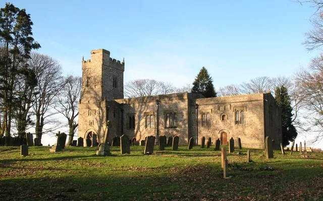
St Mary's Church, South Cowton
Historic churches · 2.1 km

Streetlam
Towns & cities · 2.4 km

Temple Cowton Preceptory
Abbeys & priories · 2.9 km

East Cowton War Memorial
Memorials & monuments · 3.0 km
Nearby
📷 5Memorials & monuments · Yorkshire & the Humber
Water Tower Approximately 30 Metres To North West Of Pepper Arden Hall
Water Tower Approximately 30 Metres To North West Of Pepper Arden Hall — a water tower in england-yorkshire, United Kingdom.
📷 4Historic houses · North East England
Pepper Arden
Pepper Arden in England North East, United Kingdom.
📷 5Vineyards · Yorkshire & the Humber
South Cowton deserted medieval village, immediately south west of Cowton Castle
South Cowton deserted medieval village, immediately south west of Cowton Castle — a UK vineyard in england yorkshire, producing English or Welsh wine from cool-climate grape varieties.
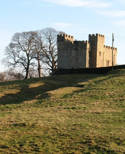
📷 5📷 5Castles · Yorkshire & the Humber
South Cowton Castle
South Cowton Castle — Grade I listed castle in South Cowton, North Yorkshire, England, UK.
📷 4Castles · North East England
South Cowton
South Cowton in England North East, United Kingdom.
Where to eat & stay near Gilling East Wapentake
Places to stay
 📷 5
📷 5Caravan parks · Yorkshire & the Humber
Ellerton Park
Ellerton Park — a caravan park in england yorkshire.
 📷 5
📷 5 📷 5
📷 5Caravan parks · Yorkshire & the Humber
Canada Fields
Canada Fields — a caravan park in england yorkshire.
 📷 5
📷 5Caravan parks · Yorkshire & the Humber
Hutton Bonville Caravan Park
Hutton Bonville Caravan Park — a caravan park in england yorkshire.
 📷 5
📷 5Caravan parks · Yorkshire & the Humber
Wiske Moor Caravan Park
Wiske Moor Caravan Park — a caravan park in england yorkshire.
 📷 5
📷 5Places to eat & drink
📷 5 📷 4
📷 4 📷 5
📷 5Historic pubs · Yorkshire & the Humber
The Three Horseshoes Inn
The Three Horseshoes Inn in England Yorkshire, United Kingdom.
 📷 7
📷 7Historic pubs · North East England
The Comet Public House
The Comet Public House in England North East, United Kingdom.
 📷 7
📷 7Restaurants · Yorkshire & the Humber
The Optimist
The Optimist — a restaurant in england yorkshire.
 📷 5
📷 5Historic pubs · Yorkshire & the Humber
The Fleece Inn
The Fleece Inn in England Yorkshire, United Kingdom.
More places in this region
 📷 5
📷 5Other places · North East England
Appleby Horse Fair
The Appleby Horse Fair, previously known as Appleby New Fair, is an annual gathering of Romani people (Gypsies) and Travellers in Appleby-in-Westmorland in Cumbria, England. The horse fair is held eac
 📷 5
📷 5Other places · North East England
Crosby Garrett
Crosby Garrett in England North East, United Kingdom.
 📷 5
📷 5Other places · North East England
Ravenstonedale
Ravenstonedale in England North East, United Kingdom.
 📷 5
📷 5Frequently asked questions
- Where is Gilling East Wapentake?
- Gilling East Wapentake is in North-East England, United Kingdom (postcode DL7 0JE), in the parish of South Cowton.
- What is Gilling East Wapentake?
- Gilling East Wapentake in England North East, United Kingdom.
- How do I get to Gilling East Wapentake?
- The nearest railway station is Scruton, about 9.0 km away. Drivers can use postcode DL7 0JE.
- How do I get to Gilling East Wapentake?
- Drivers can navigate to postcode DL7 0JE. It sits within the Richmond and Northallerton parliamentary constituency.