
Towns & cities · East Midlands
Gedney
Also known as: Gedney, Swydd Lincoln
Gedney — village in South Holland, Lincolnshire, United Kingdom.

Wikimedia Commons contributors — see linked file page for photographer and licence licence

Plan your visit
- Typical visit
- 3 h–6 h
- Free entry
- Family-friendly
- Dog-friendly
About
Gedney is a town, city, village or settlement in the United Kingdom. Recent population estimates put it at around 2,305 people. Address: PE12. Wikidata describes it as: "village in South Holland, Lincolnshire, United Kingdom". Coordinates: 52.7978°, 0.0798°.
Photo gallery
Protected designations
- Site of Special Scientific Interest: The Wash SSSI
- National Nature Reserve: THE WASH
- Ramsar wetland: The Wash
Designations sourced from Natural England open data under OGL v3.
From the Wikipedia article
Gedney () is a village, civil parish and electoral ward in the South Holland district of Lincolnshire, England. It is just to the south of the A17, from Boston to King's Lynn, 2 miles (3.2 km) east from Holbeach, and 2 miles (3.2 km) north-west from Long Sutton. The parish stretches east to The Wash and its villages and hamlets include Dawsmere, Gedney Broadgate, Gedney Drove End, Gedney Dyke, Gedney Marsh, and the geographic extension of Gedney Church End.
Excerpt from Wikipedia under CC BY-SA 4.0. See the source article linked in Sources below.
Background
History
A hospital for five paupers, of St Thomas Martyr, was founded at Gedney and served from North Creake. It was dissolved in around 1339. The redundant railway station, which was on the former east to west Midland and Great Northern Joint Railway, closed in 1959. The Red House windfarm, which was built in 2006, has six MM82 wind turbines to produce 12MW of power to supply 6,500 homes.
Sourced from Wikipedia under CC BY-SA 4.0.
- Coordinates
- 52.7978, 0.0798
- County
- Lincolnshire
- District
- South Holland
- Parish
- Gedney
- Postcode
- PE12
- Parliamentary constituency
- South Holland and The Deepings
- Population
- 2,305
- Official site
- www.neighbourhood.statistics.gov.uk
Sources
- wikidata: Q656139 (CC0)
- wikipedia: Gedney, Lincolnshire (CC BY-SA 4.0)
- commons: Gedney Church - geograph.org.uk - 28552.jpg (CC BY-SA 4.0)
Other places nearby
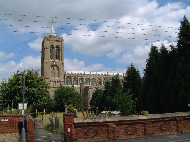
St Mary Magdalene Church, Gedney
Historic churches · 0.1 km

Fleet
Villages · 1.5 km

Fleet, Lincolnshire
Historic churches · 1.5 km

Gedney Dyke War Memorial
Memorials & monuments · 2.0 km

Fleet Motte
Literary houses · 2.1 km

Laurel Park Caravan & Camp Site
Campsites · 2.1 km

Seadike Mill
Mills · 2.3 km

Number 18, Formerly The Cock And Magpie Public House
Historic pubs · 2.6 km

Long Sutton
Villages · 2.9 km

Long Sutton, Lincolnshire
Museums · 3.0 km

Dougie's Caravan and Camping
Caravan parks · 3.1 km

Lutton War Memorial
Memorials & monuments · 3.2 km
Gedney is a town in Lincolnshire, located in the East Midlands. Visitors can explore the historic Moulton Windmill and the nearby Moulton Castle. The area also offers significant religious sites, including St Mary Magdalene Church in Gedney and St Mary Magdalene Church in Sutton St James.
At a glance
- Population
- 2,305
- Administrative county
- Lincolnshire
- Constituency
- South Holland and The Deepings
- Top categories near here
Things to see in Gedney
55 attractions within 12 km — showing the 24 most editorially-significant. Full guide: things to do in Gedney →
📷 5Historic pubs · East Midlands
Number 18, Formerly The Cock And Magpie Public House
Number 18, Formerly The Cock And Magpie Public House in England East, United Kingdom.
 📷 3
📷 3 📷 5
📷 5Windmills · East Midlands
Moulton Windmill
Moulton Windmill is a windmill in the United Kingdom.
📷 3Mills · East Midlands
Seadike Mill
Seadike Mill — mill in Gedney, South Holland, Lincolnshire, England, UK.
 📷 3
📷 3Mills · East Midlands
Sneaths Mill
Sneaths Mill — Grade I listed mill in South Holland, United Kingdom.
📷 5Historic churches · East Midlands
St Mary Magdalene Church, Gedney
St Mary Magdalene Church, Gedney — church in Gedney, South Holland, Lincolnshire, England, United Kingdom.
 📷 3
📷 3Historic houses · East Midlands
Royal Observer Corps Post, Moulton Chapel
Royal Observer Corps Post, Moulton Chapel — a historic house in East Midlands, United Kingdom.
 📷 3
📷 3Historic houses · East Midlands
Royal Observer Corps Post, Holbeach
Royal Observer Corps Post, Holbeach — a historic house in East Midlands, United Kingdom.
 📷 3
📷 3Zoos & aquariums · East Midlands
The Butterfly and Wildlife Parh
The Butterfly and Wildlife Parh — a zoo aquarium in East Midlands, United Kingdom.
 📷 3
📷 3Galleries · East Midlands
Skylark Studio Gallery
Skylark Studio Gallery — a gallery in East Midlands, United Kingdom.
 📷 3
📷 3Historic churches · East Midlands
Bell Tower, South East Of Church Of St Giles
Bell Tower, South East Of Church Of St Giles — a Grade I-listed church in england-east-midlands, United Kingdom.
 📷 3
📷 3Historic houses · East Midlands
Elloe Stone
Elloe Stone — a Grade II-listed historic house in england-east-midlands, United Kingdom.
 📷 3
📷 3Historic houses · East Midlands
Boundary cross, Old Fen Dike
Boundary cross, Old Fen Dike — a Grade II-listed historic house in england-east-midlands, United Kingdom.
 📷 3
📷 3Historic churches · East Midlands
Churchyard cross, St Mary's churchyard
Churchyard cross, St Mary's churchyard — a Grade II-listed church in england-east-midlands, United Kingdom.
 📷 3
📷 3Historic houses · East Midlands
St Ives Cross
St Ives Cross — a Grade II-listed historic house in england-east-midlands, United Kingdom.
 📷 3
📷 3Manor houses · East Midlands
Tysdale Manor
Tysdale Manor — Grade II listed building-listed manor in england-east-midlands, United Kingdom.
 📷 3
📷 3Historic bridges · East Midlands
Foremans Bridge
Foremans Bridge — Grade II listed building-listed bridge in england-east-midlands, United Kingdom.
 📷 3
📷 3Windmills · East Midlands
Penny Hill Windmill
Penny Hill Windmill — Grade II listed building-listed windmill in england-east-midlands, United Kingdom.
 📷 3
📷 3Memorials & monuments · East Midlands
Holbeach St Marks War Memorial
Holbeach St Marks War Memorial — Grade II listed building-listed memorial in england-east-midlands, United Kingdom.
 📷 3
📷 3Memorials & monuments · East Midlands
War Memorial in the Churchyard of Christ Church, Gedney Dawsmere
War Memorial in the Churchyard of Christ Church, Gedney Dawsmere — Grade II listed building-listed memorial in england-east-midlands, United Kingdom.
📷 3Memorials & monuments · East Midlands
Gedney Dyke War Memorial
Gedney Dyke War Memorial — Grade II listed building-listed memorial in england-east-midlands, United Kingdom.
📷 3Memorials & monuments · East Midlands
Lutton War Memorial
Lutton War Memorial — Grade II listed building-listed memorial in england-east-midlands, United Kingdom.
 📷 3
📷 3Public art & sculpture · East Midlands
Saracen's Head Village Sign
Saracen's Head Village Sign — a public art in East Midlands, United Kingdom.
📷 3Public art & sculpture · East Midlands
Tydd St Giles Village Sign
Tydd St Giles Village Sign — a public art in East Midlands, United Kingdom.
Nearby
📷 5Historic churches · East Midlands
St Mary Magdalene Church, Gedney
St Mary Magdalene Church, Gedney — church in Gedney, South Holland, Lincolnshire, England, United Kingdom.
📷 5📷 5Historic churches · East Midlands
Fleet, Lincolnshire
Fleet, Lincolnshire — a church in england-east-midlands, United Kingdom.
📷 3Memorials & monuments · East Midlands
Gedney Dyke War Memorial
Gedney Dyke War Memorial — Grade II listed building-listed memorial in england-east-midlands, United Kingdom.
📷 5Literary houses · East Midlands
Fleet Motte
Fleet Motte — a literary house museum in england east midlands.
📷 5Campsites · East Midlands
Laurel Park Caravan & Camp Site
Laurel Park Caravan & Camp Site — a campsite in england east midlands.
Where to eat & stay near Gedney
Places to stay
📷 5Campsites · East Midlands
Laurel Park Caravan & Camp Site
Laurel Park Caravan & Camp Site — a campsite in england east midlands.
📷 5Caravan parks · East Midlands
Dougie's Caravan and Camping
Dougie's Caravan and Camping — a caravan park in england east midlands.
 📷 5
📷 5 📷 5
📷 5Caravan parks · East Midlands
The BlueBell Inn
The BlueBell Inn — a caravan park in england east midlands.
📷 5Caravan parks · East Midlands
The Bluebell Inn
The Bluebell Inn — a caravan park in england east midlands.
 📷 5
📷 5Caravan parks · East Midlands
Eau Dyke Bank Caravan Park
Eau Dyke Bank Caravan Park — a caravan park in england east midlands.
Places to eat & drink
📷 5Historic pubs · East Midlands
Number 18, Formerly The Cock And Magpie Public House
Number 18, Formerly The Cock And Magpie Public House in England East, United Kingdom.
 📷 5
📷 5Historic pubs · East Midlands
Ship Albion Public House
Ship Albion Public House in England East, United Kingdom.
 📷 5
📷 5Historic pubs · East Midlands
Lincoln Arms Public House
Lincoln Arms Public House in England East, United Kingdom.
 📷 5
📷 5 📷 5
📷 5Restaurants · East Midlands
Imperial
Imperial — a restaurant in england london.
 📷 5
📷 5Historic pubs · East Midlands
The Black Swan Public House Premises Occupied By Rodi Property Co Ltd
The Black Swan Public House Premises Occupied By Rodi Property Co Ltd in England East, United Kingdom.
More towns in this region
 📷 5
📷 5 📷 5
📷 5Towns & cities · East Midlands
Marholm
Marholm — village and civil parish in Cambridgeshire, UK.
 📷 5
📷 5Towns & cities · East Midlands
Thornhaugh
Thornhaugh — village and civil parish in Cambridgeshire, UK.
 Flagship📷 4
Towns & cities · East Midlands
Austerfield
Austerfield — village and civil parish in South Yorkshire, England, UK.
Frequently asked questions
- Where is Gedney?
- Gedney is in Lincolnshire, the East Midlands, United Kingdom (postcode PE12), in the parish of Gedney.
- What is Gedney?
- Gedney — village in South Holland, Lincolnshire, United Kingdom.
- How do I get to Gedney?
- Drivers can use postcode PE12.
- Is Gedney a protected site?
- Yes — Gedney is part of the The Wash SSSI Site of Special Scientific Interest and the THE WASH National Nature Reserve.
- Is Gedney free to visit?
- Yes, Gedney is free to enter.
- How do I get to Gedney?
- Drivers can navigate to postcode PE12. It sits within the South Holland and The Deepings parliamentary constituency.