
Manor houses · South East England
Furzedown House
In or near Michelmersh.
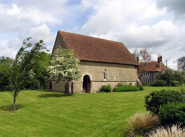
Furzedown House — a manor in South East England, United Kingdom.

Stuart Logan — CC BY-SA 2.0 via Wikimedia Commons licence

Plan your visit
- Typical visit
- 1 h–2 h
- Nearest railway station
- Mottisfont & Dunbridge · 5.6 km
- Limited wheelchair access
About
Furzedown House is a manor located in South East England, United Kingdom. Sourced from OpenStreetMap (ODbL licence); see local listings for visitor information, opening hours and admission details.
Photo gallery
Protected designations
- Site of Special Scientific Interest: River Test SSSI
Designations sourced from Natural England open data under OGL v3.
Place summary
Furzedown House is a manor located in South-East England. The property is notable for its historical significance and architectural features characteristic of the era it was built in. It is a designated listed building.
AI-generated from the structured facts on this page (operator, designation, listing, era). Not a substitute for visiting.
- Coordinates
- 51.0591, -1.4777
- County
- Hampshire
- District
- Test Valley
- Parish
- Kings Somborne
- Postcode
- SO20 6QL
- Parliamentary constituency
- Romsey and Southampton North
- Nearest railway station
- Mottisfont & Dunbridge — 5.6 km
Sources
- osm: way/975043987 (ODbL)
Other places nearby

Dirty Mount
Archaeological sites · 1.0 km
Church of St John the Baptist, Upper Eldon
Historic churches · 1.2 km

Claredon House
Manor houses · 1.2 km

Old Farley House
Historic houses · 1.6 km

Ashley Park
Manor houses · 1.7 km

Worzel Gummidge Memorial
Memorials & monuments · 1.9 km

Compton Manor
Manor houses · 1.9 km

Red Hill
Mountains & hills · 1.9 km

John of Gaunt Palace Ruins
Palaces · 2.0 km

Kings Somborne War Memorial
Memorials & monuments · 2.1 km

Parnell Barn & Cottage
Historic houses · 2.1 km

Stroud's Wood
Mountains & hills · 2.2 km
Nearby
📷 3Archaeological sites · South East England
Dirty Mount
Dirty Mount — an archaeological site in South East England, United Kingdom.
📷 5Historic churches · South East England
Church of St John the Baptist, Upper Eldon
Church of St John the Baptist, Upper Eldon — church in Upper Eldon, Hampshire, England, UK.
📷 5Manor houses · South East England
Claredon House
Claredon House — a manor in South East England, United Kingdom.
📷 5Historic houses · South East England
Old Farley House
Old Farley House — a historic house in South East England, United Kingdom.
📷 5Memorials & monuments · South East England
Worzel Gummidge Memorial
Worzel Gummidge Memorial — a memorial in South East England, United Kingdom.
Where to eat & stay near Furzedown House
Places to stay
 📷 7
 📷 5
Campsites · South East England
Three Trees Campsite
Three Trees Campsite — a campsite in england south east.
 📷 4
Campsites · South East England
Stockbridge View Campsite
Stockbridge View Campsite — a campsite in england south east.
 📷 5
 📷 5
 📷 7
Hotels · South East England
The White Horse
The White Horse — a hotel in england south east.
Places to eat & drink
 📷 5
 📷 7
Historic pubs · South East England
Hunters Inn Public House
Hunters Inn Public House in England South East, United Kingdom.
 📷 5
Historic pubs · South East England
The Tally Ho Public House
The Tally Ho Public House in England South East, United Kingdom.
 📷 7
 📷 5
Historic pubs · South East England
Bishop Blaize Public House
Bishop Blaize Public House in England South East, United Kingdom.
 📷 5
Historic pubs · South East England
Latimer Arms Public House
Latimer Arms Public House in England South East, United Kingdom.
More places in this region
 📷 5
Manor houses · South East England
Albury Manor
Albury Manor — a manor in South East England, United Kingdom.
 📷 5
Manor houses · South East England
Weardale Manor
Weardale Manor — a manor in South East England, United Kingdom.
 📷 5
Manor houses · South East England
Rowbarns Manor
Rowbarns Manor — a manor in South East England, United Kingdom.
 📷 5
Manor houses · South East England
Sutton Place
Sutton Place — a manor in South East England, United Kingdom.
Frequently asked questions
- Where is Furzedown House?
- Furzedown House is in Hampshire, South-East England, United Kingdom (postcode SO20 6QL), in the parish of Kings Somborne.
- What is Furzedown House?
- Furzedown House — a manor in South East England, United Kingdom.
- How do I get to Furzedown House?
- The nearest railway station is Mottisfont & Dunbridge, about 5.6 km away. The nearest town is Michelmersh. Drivers can use postcode SO20 6QL.
- Is Furzedown House a protected site?
- Yes — Furzedown House is part of the River Test SSSI Site of Special Scientific Interest.
- How do I get to Furzedown House?
- The nearest railway station is Mottisfont & Dunbridge, about 5.6 km away. Drivers can navigate to postcode SO20 6QL.