
Mountains & hills · North Wales
Foryd Bay
In or near Newborough.
Foryd Bay is a mountain or hill in the United Kingdom.

Wikimedia Commons contributors — see linked file page for photographer and licence licence

Plan your visit
- Typical visit
- 3 h–8 h
- Best time of year
- Late spring – early autumn (May–Oct)
- Nearest railway station
- Bontnewydd · 3.0 km
- Free entry
- Dog-friendly
Getting there & planning your visit
To visit Foryd Bay, the nearest railway station is Bontnewydd, which is 3 km away. The postcode for sat-nav is LL54 5RA, and entry to the site is free.
About
Foryd Bay is a named summit in the United Kingdom. Coordinates: 53.1129°, -4.3201°. This entry is part of The Great Britain Guide, a free, ad-free, open-data tourist directory.
Photo gallery
From the Wikipedia article
Foryd Bay, or Y Foryd (Welsh for 'the estuary' / 'the inlet'), is a tidal bay in Gwynedd, Wales. It is located at the south-western end of the Menai Strait, about two miles south-west of Caernarfon. Several rivers flow into the bay and there are large areas of mudflats and salt marsh. A shingle spit partly blocks the mouth of the bay. At the north-western end is Fort Belan, built during the 18th century. Aerial photography in the drought of 2018 identified rectangular structures possibly of Roman age, at Glan y Mor, on slightly raised ground adjacent to the shoreline. This layout is very unusual in Roman Wales; it is rectilinear but has no defences and is otherwise unlike the military Roman sites in Wales, nor does it resemble the native defended settlements with their roundhouses and irregular outlines, nor the occasional villas. It is similar to the buildings and ditched enclosures excavated on the other side of the Menai Strait at Tai Cochion. To the south is a rectangular ditched structure or possible building, with an internal subdivision, measuring 25 by 13 m. To the north is a pair of almost identical structures; both groups are linked by a linear ditch or boundary. Close by, an early field system runs north-west to south-east between Plas Farm and the shores of the Menai Strait; the fields are rectangular, with at least one visible ditched hollow way. The bay has been designated a Site of Special Scientific Interest and in 1994 it became a Local Nature Reserve because of its importance for wildlife. Many birds visit in winter and during migration, including large numbers of wildfowl and waders such as wigeon which peak at over 3000 birds. Notable species include brent goose, jack snipe, spotted redshank and greenshank. Terns roost at the mouth of the bay.
Excerpt from Wikipedia under CC BY-SA 4.0. See the source article linked in Sources below.
- Coordinates
- 53.1129, -4.3201
- District
- Gwynedd
- Parish
- Bontnewydd
- Postcode
- LL54 5RA
- Parliamentary constituency
- Dwyfor Meirionnydd
- Nearest railway station
- Bontnewydd — 3 km
Sources
- wikidata: Q20580113 (CC0)
- wikipedia: Foryd Bay (CC BY-SA 4.0)
- commons: Foryd Bay.jpg (CC BY-SA 4.0)
Other places nearby
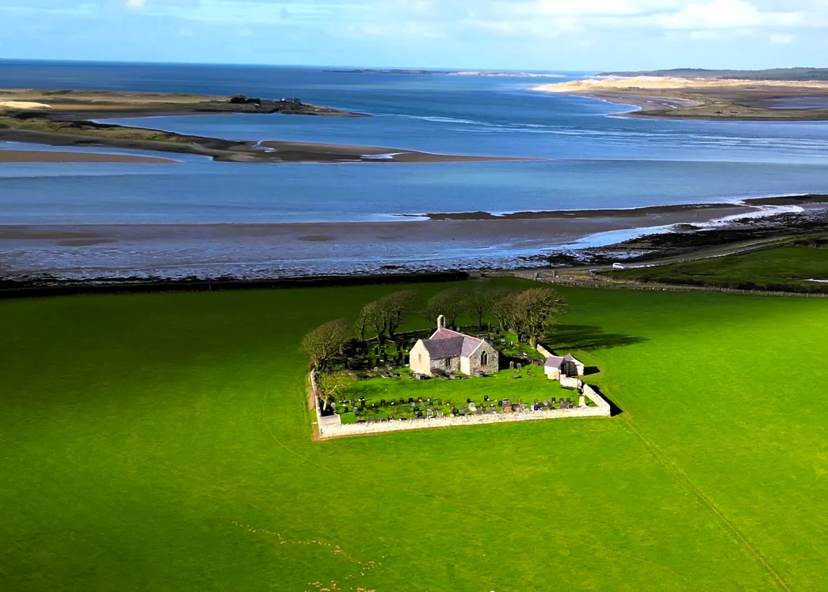
St Baglan's Church, Llanfaglan
Historic churches · 1.1 km

Morfa Lodge Holiday Park
Caravan parks · 1.2 km

Fort Belan
Forts · 1.3 km

Caer y Belan
Castles · 1.4 km

Caer y Belan
Castles · 1.4 km

White Tower Caravan Park
Caravan parks · 1.7 km

Caernarfon Airworld Museum
Museums · 1.9 km

Llanfaglan
Historic churches · 2.3 km

Dinas Dinoethwy
Vineyards · 2.9 km

Dinas Caravan Park
Caravan parks · 3.0 km

Monument to J W Jones and family
Memorials & monuments · 3.0 km

Traeth Abermenai
Beaches · 3.1 km
Nearby
📷 3Historic churches · North Wales
St Baglan's Church, Llanfaglan
St Baglan's Church, Llanfaglan — church in Llanfaglan, north Wales.
📷 5Caravan parks · North Wales
Morfa Lodge Holiday Park
Morfa Lodge Holiday Park — a caravan park in wales north.
📷 5Forts · North Wales
Fort Belan
Fort Belan (alternative: Belan Fort; pronounced: Bell-ann) is a coastal fortress in North Wales. It is located opposite Abermenai Point, at the south-western end of the Menai Strait, on the coast of G
📷 3📷 5📷 5Caravan parks · North Wales
White Tower Caravan Park
White Tower Caravan Park — a caravan park in wales north.
Where to eat & stay near Foryd Bay
Places to stay
📷 5Caravan parks · North Wales
Morfa Lodge Holiday Park
Morfa Lodge Holiday Park — a caravan park in wales north.
📷 5Caravan parks · North Wales
White Tower Caravan Park
White Tower Caravan Park — a caravan park in wales north.
📷 5 📷 5
📷 5Caravan parks · North Wales
Caernarfon Bay Holiday Park
Caernarfon Bay Holiday Park — a caravan park in wales north.
 📷 5
📷 5Caravan parks · North Wales
Coed Helen Caravan Park
Coed Helen Caravan Park — a caravan park in wales north.
 📷 5
📷 5Hostels · North Wales
Totters Independent Hostel
Totters Independent Hostel — a hostel in wales north.
Places to eat & drink
 📷 5
📷 5 📷 5
📷 5 📷 5
📷 5 📷 5📷 5
 📷 5
📷 5More mountains in this region
 📷 5
📷 5Mountains & hills · North Wales
Cemlyn Bay and lagoon
Cemlyn Bay and lagoon — Site of Special Scientific Interest in Wales.
 📷 3
📷 3Mountains & hills · North Wales
Aberffraw Bay
Aberffraw Bay — bay on the west coast of Anglesey, in Wales, UK.
 📷 3
📷 3 📷 3
📷 3Mountains & hills · North Wales
Aran Benllyn
Aran Benllyn — Named summit at 884 m.
Frequently asked questions
- Where is Foryd Bay?
- Foryd Bay is in North Wales, United Kingdom (postcode LL54 5RA), in the parish of Bontnewydd.
- What is Foryd Bay?
- Foryd Bay is a mountain or hill in the United Kingdom.
- How do I get to Foryd Bay?
- The nearest railway station is Bontnewydd, about 3.0 km away. Drivers can use postcode LL54 5RA.
- Is Foryd Bay free to visit?
- Yes, Foryd Bay is free to enter.
- How do I get to Foryd Bay?
- The nearest railway station is Bontnewydd, about 3.0 km away. Drivers can navigate to postcode LL54 5RA.