
Historic bridges · West Midlands
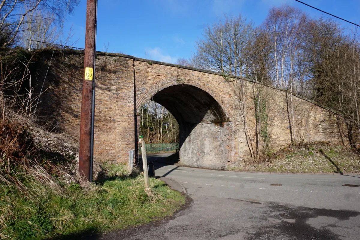
Former Canal Bridge About 130 Metres South Of Methodist Chapel
In or near Coalbrookdale.
Former Canal Bridge About 130 Metres South Of Methodist Chapel — Grade II listed building-listed bridge in england-west-midlands, United Kingdom.

Ian S — CC BY-SA 2.0 via Wikimedia Commons licence

Plan your visit
- Typical visit
- 15 min–30 min
- Nearest railway station
- Horsehay & Dawley · 1.7 km
- Free entry
- Dog-friendly
Getting there & planning your visit
The Former Canal Bridge is located in Telford and Wrekin, with the postcode TF4 3JD. The nearest railway station is Horsehay & Dawley, which is 1.7 km away. Entry to the bridge is free.
About
Former Canal Bridge About 130 Metres South Of Methodist Chapel is a Grade II listed building-listed bridge in england-west-midlands, United Kingdom, registered on the National Heritage List for England (NHLE entry 1258461). Listed status protects buildings and structures of special architectural or historic interest. See the linked Wikipedia article for further details.
Photo gallery
Heritage listing
Details DAWLEY HAMLETS LIGHTMOOR ROAD SJ 60 NE Former canal bridge 31/10002 about 130 metres south of Methodist Chapel II Canal bridge. Circa 1790 to early C19. Stretcher bond red brick round arch on dressed sandstone plinth forming a barrel vaulted tunnel, about 5 metres long, through bank of spoil. Stone rubble and slag abutments at either end. The bridge now has a footpath above, but may have originally carried a colliery plateway over the line of the Shropshire Union Canal (completed in circa 1790). The 1882 OS map indicates that the canal was replaced by a small mineral line. The bridge probably connected Dawley Parva Colliery to Lightmoor Iron, Brick and Tile Works. Sources: Ironbridge Gorge Museum Trust; 1840 Tithe Map and 1882 OS Map. Listing NGR: SJ6827405850 Legacy The contents of this record have been generated from a legacy data system. Legacy System number: 445013 Legacy System: LBS
From the Historic England List Entry under OGL v3.
Place summary
The Former Canal Bridge, located about 130 metres south of the Methodist Chapel in Dawley Hamlets, West Midlands, is a Grade II listed building. This designation highlights its historical significance and architectural merit within the area.
AI-generated from the structured facts on this page (operator, designation, listing, era). Not a substitute for visiting.
- Coordinates
- 52.6495, -2.4704
- District
- Telford and Wrekin
- Parish
- Dawley Hamlets
- Postcode
- TF4 3JD
- Parliamentary constituency
- Telford
- Nearest railway station
- Horsehay & Dawley — 1.7 km
Sources
- wikidata: Q26549693 (CC0)
Other places nearby
Telford Steam Railway
Heritage railways · 1.0 km

Madeley Academy
Natural landmarks · 1.1 km

Museum of Steel Sculpture
Museums · 1.2 km

Madeley Court
Gardens · 1.4 km

Dawley
Museums · 1.5 km

Madeley Court Mill
Windmills · 1.6 km

Horsehay
Villages · 1.6 km

Parkhurst Cinema
Theatres · 1.8 km

The Coalbrookdale Inn
Historic pubs · 1.8 km

Darby Houses
Museums · 1.8 km

The Darby Houses
Museums · 1.8 km

Madeley
Mountains & hills · 1.8 km
Nearby
📷 3Heritage railways · West Midlands
Telford Steam Railway
Telford Steam Railway is a heritage railway in the United Kingdom.
📷 5Natural landmarks · West Midlands
Madeley Academy
Madeley Academy — a school heritage in england-west-midlands, United Kingdom.
📷 3Museums · West Midlands
Museum of Steel Sculpture
Museum of Steel Sculpture — a museum in england-west-midlands, United Kingdom.
📷 4Gardens · West Midlands
Madeley Court
Madeley Court — a garden in england-west-midlands, United Kingdom.
📷 5Museums · West Midlands
Dawley
Dawley ( DAW-lee) is a former mining town and civil parish in the borough of Telford and Wrekin, Shropshire, England. It was originally proposed to be the main centre of the 'Dawley New Town' plan in
📷 3Windmills · West Midlands
Madeley Court Mill
Madeley Court Mill is a windmill in the United Kingdom.
Where to eat & stay near Former Canal Bridge About 130 Metres South Of Methodist Chapel
Places to stay
 📷 5
📷 5 📷 5
📷 5Campsites · West Midlands
Iron Gorge Camping
Iron Gorge Camping — a campsite in england west midlands.
 📷 5
📷 5 📷 5
📷 5Caravan parks · West Midlands
Pool View Caravan Park
Pool View Caravan Park — a caravan park in england west midlands.
 📷 5
📷 5 📷 5
📷 5Hotels · West Midlands
Premier Inn (Telford Central)
Premier Inn (Telford Central) — a hotel in england west midlands. 3-star. Brand: Premier Inn.
Places to eat & drink
📷 7Historic pubs · West Midlands
The Coalbrookdale Inn
The Coalbrookdale Inn in England West Midlands, United Kingdom.
 📷 5
📷 5Historic pubs · West Midlands
The Beacon Public House
The Beacon Public House in England West Midlands, United Kingdom.
 📷 5
📷 5Historic pubs · West Midlands
The Golden Ball Public House
The Golden Ball Public House in England West Midlands, United Kingdom.
 📷 5
📷 5Historic pubs · West Midlands
Crown Inn Including Outbuildings Adjoining South West
Crown Inn Including Outbuildings Adjoining South West in England West Midlands, United Kingdom.
 📷 5
📷 5Historic pubs · West Midlands
All Nations Inn
All Nations Inn in England West Midlands, United Kingdom.
 📷 5
📷 5Historic pubs · West Midlands
The Brewery Inn
The Brewery Inn in England West Midlands, United Kingdom.
More bridges in this region
 📷 3
📷 3Historic bridges · West Midlands
Wolseley Bridge
Wolseley Bridge is a historic bridge in the United Kingdom.
 📷 3
📷 3Historic bridges · West Midlands
Bridge, Gatepiers, Walls And Ha Ha South Of Blithfield Hall
Bridge, Gatepiers, Walls And Ha Ha South Of Blithfield Hall — Grade II listed building-listed bridge in england-east-midlands, United Kingdom.
 📷 3
📷 3Historic bridges · West Midlands
Bridge Over River Swarbourn At West End Of Town Hill
Bridge Over River Swarbourn At West End Of Town Hill — Grade II listed building-listed bridge in england-east-midlands, United Kingdom.
 📷 3
📷 3Historic bridges · West Midlands
Viaduct over Trent and Mersey Canal at SK 0485 1780
Viaduct over Trent and Mersey Canal at SK 0485 1780 — Grade II listed building-listed bridge in england-east-midlands, United Kingdom.
Frequently asked questions
- Where is Former Canal Bridge About 130 Metres South Of Methodist Chapel?
- Former Canal Bridge About 130 Metres South Of Methodist Chapel is in the West Midlands, United Kingdom (postcode TF4 3JD), in the parish of Dawley Hamlets.
- What is Former Canal Bridge About 130 Metres South Of Methodist Chapel?
- Former Canal Bridge About 130 Metres South Of Methodist Chapel — Grade II listed building-listed bridge in england-west-midlands, United Kingdom.
- How do I get to Former Canal Bridge About 130 Metres South Of Methodist Chapel?
- The nearest railway station is Horsehay & Dawley, about 1.7 km away. Drivers can use postcode TF4 3JD.
- Is Former Canal Bridge About 130 Metres South Of Methodist Chapel a listed building?
- Former Canal Bridge About 130 Metres South Of Methodist Chapel is officially recognised as Grade II listed building listed.
- Is Former Canal Bridge About 130 Metres South Of Methodist Chapel free to visit?
- Yes, Former Canal Bridge About 130 Metres South Of Methodist Chapel is free to enter.
- How do I get to Former Canal Bridge About 130 Metres South Of Methodist Chapel?
- The nearest railway station is Horsehay & Dawley, about 1.7 km away. Drivers can navigate to postcode TF4 3JD.