
Abbeys & priories · Central Scotland
Fishwick
In or near Norham.
Fishwick in England North East, United Kingdom.

Martin Dawes — CC BY-SA 2.0 via Wikimedia Commons licence

Plan your visit
- Typical visit
- 45 min–1.5 h
- Nearest railway station
- Berwick-upon-Tweed · 8.0 km
- Family-friendly
- Limited wheelchair access
Getting there & planning your visit
To visit Fishwick Abbey, the nearest railway station is Berwick-upon-Tweed, located 8 km away. The postcode for your sat-nav is TD15 1XQ. Accessibility is limited for wheelchair users.
About
Fishwick is a place of interest in England North East, United Kingdom — drawn from open-data sources for visitor reference. See the linked Wikipedia article for the full description.
Photo gallery
Protected designations
- Site of Special Scientific Interest: Tweed Catchment Rivers - England: Lower Tweed and Whiteadder SSSI
Designations sourced from Natural England open data under OGL v3.
From the Wikipedia article
Fishwick is a parish with a small mediaeval village (now vanished) in the Scottish Borders, Scotland, in the traditional county of Berwickshire, seven miles from Berwick-upon-Tweed. The parish church is now a ruin and the parish is united with Hutton and Paxton. Today the parish consists of farms and scattered housing. There is also an old WWII airstrip, still occasionally used. Fishwick borders the north of the River Tweed which here constitutes the border with England. Anciently Fishwick was a possession of Coldingham Priory a cell of the Bishopric of Durham. The superiorities of the Priory became part of the Barony of Coldingham which in 1621 was held by James, 2nd Earl of Home (d. 1633). A William Purves was a resident in Fishwick in Nov 1577 when he witnessed a Sasine. Just south of the Tweed from Fishwick is the northernmost village in England, Horncliffe. Between Fishwick and Horncliffe is the famous Union Bridge, a very early suspension bridge dating from 1820. When it was opened it was the longest wrought-iron suspension bridge in the world, and it is still carrying traffic, though now only one vehicle at a time. One of the toll cottages was demolished in 1955. The crossing is now toll-free.
Excerpt from Wikipedia under CC BY-SA 4.0. See the source article linked in Sources below.
- Coordinates
- 55.7534, -2.1328
- District
- Scottish Borders
- Postcode
- TD15 1XQ
- Parliamentary constituency
- Berwickshire, Roxburgh and Selkirk
- Nearest railway station
- Berwick-upon-Tweed — 8 km
Sources
- wikidata: Q5455153 (CC0)
- wikipedia: Fishwick, Scottish Borders (CC BY-SA 4.0)
Other places nearby

Fishwick Mortuary Chapel
Historic houses · 1.3 km

Union Bridge
Vineyards · 1.3 km

Fishwick Mains
Vineyards · 1.4 km

Bridge Engineer
Public art & sculpture · 1.5 km

Paxton House
Historic houses · 1.6 km

Union Chain Bridge
Historic bridges · 1.6 km

Horncliffe
Villages · 1.7 km

Captain Sir Samuel Brown of Netherbyres KH FRSE
Public art & sculpture · 1.7 km

Loanend
Vineyards · 1.7 km

Horncliffe War Memorial
Memorials & monuments · 1.7 km

Horncliffe
Natural landmarks · 1.8 km

Hutton
Villages · 1.8 km
Nearby
📷 3Historic houses · Scottish Lowlands
Fishwick Mortuary Chapel
Fishwick Mortuary Chapel — a historic house in scotland-central, United Kingdom.
📷 5Vineyards · Scottish Lowlands
Union Bridge
Union Bridge — a UK vineyard in scotland central, producing English or Welsh wine from cool-climate grape varieties.
📷 5Vineyards · Scottish Lowlands
Fishwick Mains
Fishwick Mains — a UK vineyard in scotland central, producing English or Welsh wine from cool-climate grape varieties.
📷 3Public art & sculpture · Central Scotland
Bridge Engineer
Bridge Engineer — a public art in scotland-central, United Kingdom.
📷 4Historic houses · Central Scotland
Paxton House
Paxton House in England North East, United Kingdom.
📷 3Historic bridges · Central Scotland
Union Chain Bridge
Union Chain Bridge is a historic bridge in the United Kingdom.
Where to eat & stay near Fishwick
Places to stay
 📷 5
📷 5Caravan parks · Scottish Lowlands
Chainbridge Touring Caravan Site
Chainbridge Touring Caravan Site — a caravan park in scotland central.
 📷 5
📷 5Caravan parks · North East England
Salutation Caravan Park
Salutation Caravan Park — a caravan park in scotland central.
 📷 5
📷 5Campsites · Central Scotland
Shepherd's Rest
Shepherd's Rest — a campsite in scotland central.
 📷 5
📷 5Caravan parks · North East England
Ord House Country Park
Ord House Country Park — a caravan park in scotland central.
 📷 5
📷 5 📷 5
📷 5Places to eat & drink
 📷 7
📷 7Historic pubs · Scottish Lowlands
The Victoria Hotel
The Victoria Hotel in Scotland Lowlands, United Kingdom.
 📷 5
📷 5Historic pubs · Scottish Lowlands
The Masons Arms
The Masons Arms in Scotland Lowlands, United Kingdom.
 📷 7
📷 7Historic pubs · North East England
Red Lion Public House
Red Lion Public House in Scotland Lowlands, United Kingdom.
 📷 7
📷 7Historic pubs · North East England
59 And 61, Bridge Street
59 And 61, Bridge Street in Scotland Lowlands, United Kingdom.
 📷 5
📷 5Historic pubs · North East England
The Berwick Arms
The Berwick Arms in Scotland Lowlands, United Kingdom.
 📷 7
📷 7Historic pubs · Central Scotland
The Royal Bar, 15 Market Square, Duns
The Royal Bar, 15 Market Square, Duns in Scotland Central, United Kingdom.
More abbeys in this region
 📷 4
📷 4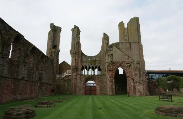 ★ Iconic📷 3
Abbeys & priories · Central Scotland
Arbroath Abbey
Arbroath Abbey — abbey in Arbroath, Scotland, United Kingdom.
 📷 4
📷 4Abbeys & priories · Central Scotland
Gartocharn
Gartocharn in Scotland Islands, United Kingdom.
 📷 4
📷 4Frequently asked questions
- Where is Fishwick?
- Fishwick is in North-East England, United Kingdom (postcode TD15 1XQ).
- What is Fishwick?
- Fishwick in England North East, United Kingdom.
- How do I get to Fishwick?
- The nearest railway station is Berwick-upon-Tweed, about 8.0 km away. Drivers can use postcode TD15 1XQ.
- Is Fishwick a protected site?
- Yes — Fishwick is part of the Tweed Catchment Rivers - England: Lower Tweed and Whiteadder SSSI Site of Special Scientific Interest.
- How do I get to Fishwick?
- Drivers can navigate to postcode TD15 1XQ. It sits within the Berwickshire, Roxburgh and Selkirk parliamentary constituency.