
Natural landmarks · South West England
Fisherman's Walk Cliff Lift
In or near Stanpit.
Fisherman's Walk Cliff Lift — a natural landmark in South West England, United Kingdom.

N Chadwick — CC BY-SA 2.0 via Wikimedia Commons licence

Plan your visit
- Typical visit
- 1 h–2 h
- Nearest railway station
- Pokesdown · 1.3 km
- Free entry
- Family-friendly
- Dog-friendly
About
Fisherman's Walk Cliff Lift is a natural landmark located in South West England, United Kingdom. Sourced from OpenStreetMap (ODbL licence); see local listings for visitor information, opening hours and admission details.
Photo gallery
Protected designations
- Site of Special Scientific Interest: Poole Bay Cliffs SSSI
Designations sourced from Natural England open data under OGL v3.
Place summary
Fisherman's Walk Cliff Lift is a natural landmark located in South-East England. It is a funicular railway that provides access to the beach from the cliff top, offering views of the surrounding coastline.
AI-generated from the structured facts on this page (operator, designation, listing, era). Not a substitute for visiting.
- Coordinates
- 50.7211, -1.8173
- Parish
- Bournemouth, Christchurch and Poole, unparished area
- Postcode
- BH6 3TD
- Parliamentary constituency
- Bournemouth East
- Nearest railway station
- Pokesdown — 1.3 km
Sources
- osm: way/25593216 (ODbL)
Other places nearby
Fisherman's Walk Beach
Viewpoints · 0.0 km
Fisherman's Walk Beach
Beaches · 0.1 km

Classic Bournemouth
Theatres · 0.2 km

View
Natural landmarks · 0.6 km

Southbourne Gallery
Galleries · 0.7 km

Peacock butterfly
Public art & sculpture · 0.7 km

Health Sciences University
University colleges · 1.1 km

Pokesdown United Reformed Church And Sunday School
Other places · 1.1 km
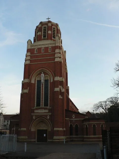
Corpus Christi Church, Boscombe
Historic churches · 1.1 km

Shelley Theatre
Open-air theatres · 1.1 km

Shelley Theatre
Theatres · 1.1 km
Wood mouse
Public art & sculpture · 1.2 km
Nearby
📷 5Viewpoints · South West England
Fisherman's Walk Beach
Fisherman's Walk Beach is a viewpoint in the United Kingdom.
📷 5Beaches · South West England
Fisherman's Walk Beach
Fisherman's Walk Beach is a beach in the United Kingdom.
📷 3Theatres · South West England
Classic Bournemouth
Classic Bournemouth in England South West, United Kingdom.
📷 5Natural landmarks · South West England
View
View — a place in South West England, United Kingdom.
📷 5Galleries · South West England
Southbourne Gallery
Southbourne Gallery — a gallery in South West England, United Kingdom.
📷 5Public art & sculpture · South West England
Peacock butterfly
Peacock butterfly — a public art in South West England, United Kingdom.
Where to eat & stay near Fisherman's Walk Cliff Lift
Places to stay
 📷 5
 📷 5
Hotels · South West England
Langtry Manor Hotel
Langtry Manor Hotel — a hotel in england south east.
 📷 5
Hostels · South West England
Bournemouth Backpackers Hotel
Bournemouth Backpackers Hotel — a hostel in england south east.
 📷 5
Hotels · South West England
Tudor Grange Hotel
Tudor Grange Hotel — a hotel in england south east.
 📷 5
Hotels · South West England
The Kings Arms Hotel
The Kings Arms Hotel — a hotel in england south east.
 📷 5
Campsites · South West England
Grove Farm Meadow Holiday and Touring Park
Grove Farm Meadow Holiday and Touring Park — a campsite in england south east.
Places to eat & drink
 📷 5
Historic pubs · South West England
The Salisbury Arms Public House
The Salisbury Arms Public House in England South West, United Kingdom.
📷 5Historic pubs · South West England
The Rising Sun Public House
The Rising Sun Public House in England South West, United Kingdom.
 📷 5
Historic pubs · South West England
Branksome Arms
Branksome Arms in England South West, United Kingdom.
 📷 5
Historic pubs · South East England
The Woolpack
The Woolpack — Historic pub — listed building or notable heritage status.
 📷 5
Cafés · South West England
Café Villano
Café Villano — a café in england south east. Cuisine: coffee shop;sandwich;ice cream;regional.
 📷 5
Historic pubs · South West England
The Brewers Arms Public House
The Brewers Arms Public House in England South West, United Kingdom.
More natural landmarks in this region
 📷 5
Natural landmarks · South West England
Arlington Row
Arlington Row at Arlington in the parish of Bibury, Gloucestershire, England was built in the late 14th century as a wool store and converted into weavers' houses in the late 17th century. It is a Gra
 📷 5
Natural landmarks · South West England
Roves Farm Visitor Centre
Roves Farm Visitor Centre — a natural landmark in South West England, United Kingdom.
 📷 4
Natural landmarks · South West England
Matchams Karting
Matchams Karting — a place in South West England, United Kingdom.
 📷 5
Natural landmarks · South West England
Avebury Down
Avebury Down — a place in South West England, United Kingdom.
Frequently asked questions
- Where is Fisherman's Walk Cliff Lift?
- Fisherman's Walk Cliff Lift is in South-East England, United Kingdom (postcode BH6 3TD), in the parish of Bournemouth, Christchurch and Poole, unparished area.
- What is Fisherman's Walk Cliff Lift?
- Fisherman's Walk Cliff Lift — a natural landmark in South West England, United Kingdom.
- How do I get to Fisherman's Walk Cliff Lift?
- The nearest railway station is Pokesdown, about 1.3 km away. The nearest town is Stanpit. Drivers can use postcode BH6 3TD.
- Is Fisherman's Walk Cliff Lift a protected site?
- Yes — Fisherman's Walk Cliff Lift is part of the Poole Bay Cliffs SSSI Site of Special Scientific Interest.
- Is Fisherman's Walk Cliff Lift free to visit?
- Yes, Fisherman's Walk Cliff Lift is free to enter.
- How do I get to Fisherman's Walk Cliff Lift?
- The nearest railway station is Pokesdown, about 1.3 km away. Drivers can navigate to postcode BH6 3TD.