Historic houses · South Wales
Fish Pond
In or near Oxwich.
Fish Pond — a historic house in wales-south, United Kingdom.

Alan Hughes — CC BY-SA 2.0 via Wikimedia Commons licence
Plan your visit
- Typical visit
- 1 h–2 h
- Family-friendly
- Limited wheelchair access
About
Fish Pond is a historic house located in wales-south, United Kingdom. Sourced from OpenStreetMap (ODbL licence); see local listings for visitor information, opening hours and admission details.
Photo gallery
Place summary
Fish Pond is a historic house located in South Wales. It is notable for its architectural significance and history within the region.
AI-generated from the structured facts on this page (operator, designation, listing, era). Not a substitute for visiting.
- Coordinates
- 51.5729, -4.1767
- District
- Swansea
- Parish
- Penrice
- Postcode
- SA3 1LN
- Parliamentary constituency
- Gower
Sources
- osm: way/24263815 (ODbL)
Other places nearby

Penrice
Villages · 0.4 km
Mountyborough
Literary houses · 0.4 km
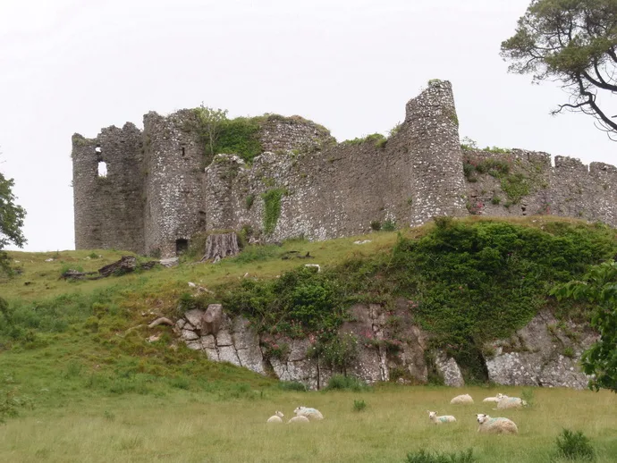
Penrice Castle
Castles · 0.5 km

Kittle Top
Castles · 0.6 km

Oxwich Towers
Historic houses · 0.9 km

Oxwich Camping Park
Campsites · 1.4 km

Perriswood Archery & Falconry Centre
Natural landmarks · 1.5 km

Norton Camp
Castles · 1.6 km

Cefn Bryn
Viewpoints · 1.6 km

Reynoldston Camp
Literary houses · 1.9 km
Greenways of Gower
Caravan parks · 1.9 km

Oxwich
Towns & cities · 1.9 km
Nearby
📷 5📷 5📷 3Castles · South Wales
Penrice Castle
Penrice Castle — castle in Penrice, Swansea, Wales, UK.
📷 5📷 3Historic houses · South Wales
Oxwich Towers
Oxwich Towers — a historic house in wales-south, United Kingdom.
📷 5Campsites · South Wales
Oxwich Camping Park
Oxwich Camping Park — a campsite in wales south.
Where to eat & stay near Fish Pond
Places to stay
📷 5Campsites · South Wales
Oxwich Camping Park
Oxwich Camping Park — a campsite in wales south.
📷 5Caravan parks · South Wales
Greenways of Gower
Greenways of Gower — a caravan park in wales south.
📷 5Hotels · South Wales
The King Arthur Hotel
The King Arthur Hotel — a hotel in wales south.
 📷 5
📷 5 📷 5
📷 5Campsites · South Wales
Eastern Slade Farm Campsite
Eastern Slade Farm Campsite — a campsite in wales south.
 📷 5
📷 5Places to eat & drink
📷 5Restaurants · South Wales
Beach House
Beach House — a restaurant in wales south.
 📷 3
📷 3Restaurants · South Wales
Croeso Lounge
Croeso Lounge — a restaurant in wales south.
 📷 3
📷 3Restaurants · South Wales
Nishimura Ltd
Nishimura Ltd — a restaurant in wales south.
 📷 3
📷 3Restaurants · South Wales
Mermaid Cafe Bar and Restaurant
Mermaid Cafe Bar and Restaurant — a restaurant in wales south.
 📷 5
📷 5 📷 5
📷 5Restaurants · South Wales
The Lighthouse Bar & Kitchen
The Lighthouse Bar & Kitchen — a restaurant in wales south.
More historic houses in this region
 📷 3
📷 3Historic houses · South Wales
Agincourt House
Agincourt House — Grade II* listed building in Monmouth. Building in Monmouth, Wales.
 📷 3
📷 3Historic houses · South Wales
Big House, Landshipping
Big House, Landshipping — house in Martletwy, Pembrokeshire, Wales, UK.
 📷 3
📷 3Historic houses · South Wales
Boverton Place
Boverton Place — building in Llantwit Major, United Kingdom.
 📷 3
📷 3Historic houses · South Wales
Brynderi House
Brynderi House — house in Llantilio Crossenny, Monmouthshire, Wales.
Frequently asked questions
- Where is Fish Pond?
- Fish Pond is in South Wales, United Kingdom (postcode SA3 1LN), in the parish of Penrice.
- What is Fish Pond?
- Fish Pond — a historic house in wales-south, United Kingdom.
- How do I get to Fish Pond?
- Drivers can use postcode SA3 1LN.
- How do I get to Fish Pond?
- Drivers can navigate to postcode SA3 1LN. It sits within the Gower parliamentary constituency.