Mountains & hills · North West England
Fellbarrow
In or near Thackthwaite.
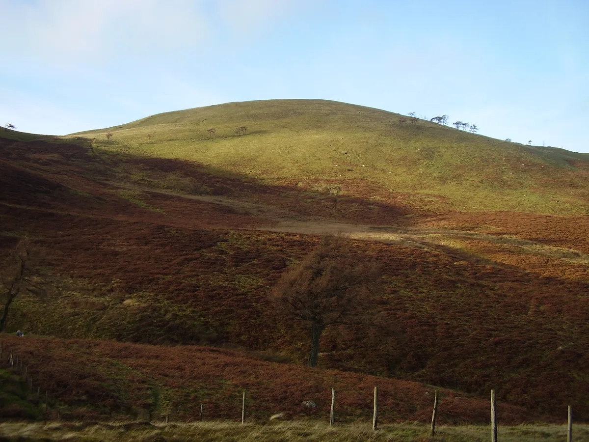
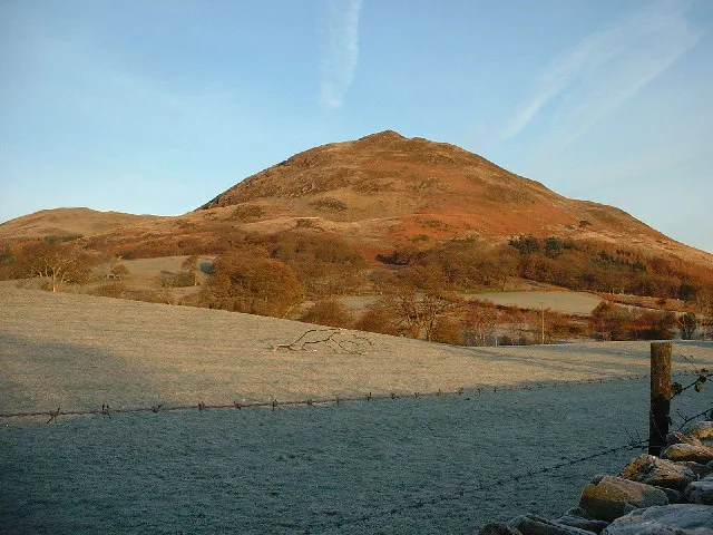
Fellbarrow — Named summit at 416 m.

Wikimedia Commons contributors — see linked file page for photographer and licence licence
Plan your visit
- Typical visit
- 3 h–8 h
- Best time of year
- Late spring – early autumn (May–Oct)
- Free entry
- Dog-friendly
About
Fellbarrow is a named summit in the United Kingdom. Wikidata describes it as: "Named summit at 416 m.". Coordinates: 54.6058°, -3.3447°.
Photo gallery
Protected designations
- Site of Special Scientific Interest: River Derwent and Tributaries SSSI
Designations sourced from Natural England open data under OGL v3.
From the Wikipedia article
Fellbarrow is a low hill in the north west of the English Lake District. It is not far from the town of Cockermouth, near to Loweswater and can most easily be climbed from Low Lorton or Thackthwaite. From the summit there are views across the Lorton valley to Grasmoor and Whiteside.
Excerpt from Wikipedia under CC BY-SA 4.0. See the source article linked in Sources below.
- Coordinates
- 54.6058, -3.3447
- District
- Cumberland
- Parish
- Loweswater
- Postcode
- CA13 0RP
- Parliamentary constituency
- Penrith and Solway
Sources
- osm: n8330032777 (ODbL)
- wikipedia: Fellbarrow (CC BY-SA 4.0)
- commons: Fellbarrow.jpg (CC BY-SA 4.0)
Other places nearby

Fellbarrow - Mosser Fell
Mountains & hills · 0.0 km
Fellbarrow
Natural landmarks · 0.2 km

Smithy Fell
Mountains & hills · 0.5 km

Hatteringill Head
Mountains & hills · 0.5 km

Sourfoot Fell
Mountains & hills · 0.9 km

Broadmoor Hill
Mountains & hills · 1.1 km

Low Fell (summit)
Mountains & hills · 1.7 km

Thackthwaite
Towns & cities · 1.7 km
Low Fell
Natural landmarks · 1.7 km

Askhill Knott
Mountains & hills · 1.7 km

Darling Fell
Mountains & hills · 1.8 km
Darling Fell
Mountains & hills · 1.8 km
Nearby
📷 5Mountains & hills · North West England
Fellbarrow - Mosser Fell
Fellbarrow - Mosser Fell — a hill or mountain in scotland lowlands.
📷 3📷 5Mountains & hills · North West England
Smithy Fell
Smithy Fell — mountain in scotland lowlands. Elevation: 392 m.
📷 5Mountains & hills · North West England
Hatteringill Head
Hatteringill Head — mountain in scotland lowlands. Elevation: 385 m.
📷 5Mountains & hills · North West England
Sourfoot Fell
Sourfoot Fell — mountain in england north east. Elevation: 411 m.
📷 5Mountains & hills · North West England
Broadmoor Hill
Broadmoor Hill — mountain in scotland lowlands. Elevation: 245 m.
Where to eat & stay near Fellbarrow
Places to stay
 📷 5
📷 5Caravan parks · North West England
Whinfell Caravan Park
Whinfell Caravan Park — a caravan park in scotland lowlands.
 📷 5
📷 5Campsites · North West England
Whinfell Hall Farm Campsite
Whinfell Hall Farm Campsite — a campsite in scotland lowlands.
 📷 5
📷 5Hostels · North West England
Swallow Barn
Swallow Barn — a hostel in england north east.
 📷 5
📷 5Caravan parks · North West England
Wheatsheaf Caravan and Camping Park
Wheatsheaf Caravan and Camping Park — a caravan park in scotland lowlands.
 📷 5
📷 5Caravan parks · North West England
Violet Bank holiday Home Park
Violet Bank holiday Home Park — a caravan park in scotland lowlands.
 📷 5
📷 5Caravan parks · North West England
Inglenook Caravan Park
Inglenook Caravan Park — a caravan park in england north east.
Places to eat & drink
 📷 7
📷 7Historic pubs · North West England
The Pheasant Inn
The Pheasant Inn in Scotland Lowlands, United Kingdom.
 📷 5
📷 5 📷 7
📷 7Cafés · North West England
Grange Bridge Cottage
Grange Bridge Cottage — a café in england north east.
 📷 5
📷 5Historic pubs · North West England
Fox and Grapes
Fox and Grapes in England North West, United Kingdom.
 📷 4
📷 4Historic pubs · North West England
Oddfellows Arms
Oddfellows Arms — Historic pub — listed building or notable heritage status.
More mountains in this region
 📷 5
📷 5Mountains & hills · North West England
Appleton Park
Appleton Park — a hill or mountain in england west midlands.
 📷 5
📷 5Mountains & hills · North West England
High Warren
High Warren — mountain in england west midlands. Elevation: 105 m.
 📷 5
📷 5Mountains & hills · North West England
Alderley Edge
Alderley Edge — mountain in england west midlands. Elevation: 194 m.
 📷 3
📷 3Frequently asked questions
- Where is Fellbarrow?
- Fellbarrow is in the Scottish Lowlands, United Kingdom (postcode CA13 0RP), in the parish of Loweswater.
- What is Fellbarrow?
- Fellbarrow — Named summit at 416 m.
- How do I get to Fellbarrow?
- Drivers can use postcode CA13 0RP.
- Is Fellbarrow a protected site?
- Yes — Fellbarrow is part of the River Derwent and Tributaries SSSI Site of Special Scientific Interest.
- Is Fellbarrow free to visit?
- Yes, Fellbarrow is free to enter.
- How do I get to Fellbarrow?
- Drivers can navigate to postcode CA13 0RP. It sits within the Penrith and Solway parliamentary constituency.