Wildlife reserves · South East England
Farnham Heath
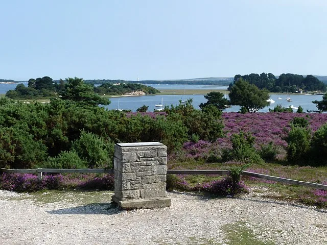
Farnham Heath — Heathland in Waverley, Surrey.

Wikimedia Commons contributors — see linked file page for photographer and licence licence
Plan your visit
- Typical visit
- 2 h–4 h
- Best time of year
- Autumn & winter (migration & wildfowl)
- Nearest railway station
- Oatlands · 0.2 km
- Free entry
- Dog-friendly
- Wheelchair accessible
About
Farnham Heath is a nature reserve in Surrey, South-East England. The site is within the Surrey Hills National Landscape (AONB), and is part of the WEALDEN HEATHS National Nature Reserve. It sits within the Farnham and Bordon parliamentary constituency. The nearest railway station is Oatlands, about 0.2 km away. Postcode area GU10.
Photo gallery
Protected designations
- National Nature Reserve: WEALDEN HEATHS
- Area of Outstanding Natural Beauty: Surrey Hills
Designations sourced from Natural England open data under OGL v3.
Place summary
Farnham Heath is a wildlife reserve located in Tilford, Surrey, South-East England. It is designated as a National Nature Reserve under the Wealden Heaths and is part of the Surrey Hills Area of Outstanding Natural Beauty. The site offers diverse habitats that support a variety of wildlife.
AI-generated from the structured facts on this page (operator, designation, listing, era). Not a substitute for visiting.
- Coordinates
- 51.1858, -0.7737
- County
- Surrey
- District
- Waverley
- Parish
- Tilford
- Postcode
- GU10 2DL
- Parliamentary constituency
- Farnham and Bordon
- Nearest railway station
- Oatlands — 0.2 km
- Official site
- rural-life.org.uk
Sources
- wikidata: Q119105053 (CC0)
- commons: Farnham Heath south entrance.jpg (CC BY-SA 4.0)
Other places nearby
Loading nearby places…
Nearby
 📷 5
📷 5Museums · South East England
Old Kiln Light Railway
The Old Kiln Light Railway is a 2 ft (610 mm) narrow gauge railway at the Rural Life Living Museum in Tilford, near Farnham, Surrey. It has a collection of historic locomotives and rolling stock inclu
 📷 5
📷 5Museums · South East England
Rural Life Living Museum, Tilford
Rural Life Living Museum, Tilford — a museum in england-south-east, United Kingdom.
 📷 5
📷 5Forests & woodlands · South East England
Bourne Wood
Bourne Wood is a forest or woodland in the United Kingdom.
.jpg?width=1200) 📷 5
📷 5Historic houses · South East England
Tilford House
Tilford House — house in Tilford, Waverley, England, UK.
Campsites · South East England
Garners Field Campsite
Garners Field Campsite — a campsite in england south east.
 📷 5
📷 5Historic bridges · South East England
Tilford West Bridge
Tilford West Bridge — a Grade I-listed bridge in england-south-east, United Kingdom.
More places in this region
 Flagship📷 10
Wildlife reserves · South East England
Arne RSPB reserve
Arne RSPB reserve — RSPB nature reserve in the United Kingdom.
 Flagship📷 10
Wildlife reserves · South East England
Farnham Park
Farnham Park — nature reserve in Surrey, England, UK.
 Flagship📷 10
Wildlife reserves · South East England
Great Wood and Dodd's Grove
Great Wood and Dodd's Grove — Essex Wildlife Trust Nature reserve.
 Flagship📷 10
Wildlife reserves · South East England
Gunners Park and Shoebury Ranges
Gunners Park and Shoebury Ranges — Essex Wildlife Trust Nature reserve.
Frequently asked questions
- Where is Farnham Heath?
- Farnham Heath is in Surrey, South-East England, United Kingdom (postcode GU10 2DL), in the parish of Tilford.
- Is Farnham Heath a protected site?
- Yes — Farnham Heath is part of the WEALDEN HEATHS National Nature Reserve and the Surrey Hills National Landscape (AONB).
- Is Farnham Heath free to visit?
- Yes, Farnham Heath is free to enter.
- How do I get to Farnham Heath?
- The nearest railway station is Oatlands, about 0.2 km away. Drivers can navigate to postcode GU10 2DL.
- Are dogs allowed at Farnham Heath?
- Most wildlife reserves allow dogs on lead only, with restrictions during ground-nesting bird season (March-July). Check signage at the reserve.