Reservoirs & lochs · North East England
Far High House Meadows
Far High House Meadows in England North East, United Kingdom.

Andrew Smith — CC BY-SA 2.0 via Wikimedia Commons licence
Plan your visit
- Typical visit
- 1 h–2.5 h
- Free entry
- Dog-friendly
About
Far High House Meadows is a place of interest in England North East, United Kingdom — drawn from open-data sources for visitor reference. See the linked Wikipedia article for the full description.
Photo gallery
Official information
Far High House Meadows is a Site of Special Scientific Interest (SSSI) located in County Durham, specifically within the Wear Valley district. It is recognized for its biological interest and features a variety of natural habitats that support diverse wildlife.
Protected designations
- Site of Special Scientific Interest: Far High House Meadows SSSI
- Area of Outstanding Natural Beauty: North Pennines
Designations sourced from Natural England open data under OGL v3.
From the Wikipedia article
Far High House Meadows is a Site of Special Scientific Interest in Upper Weardale in west County Durham, England. It consists of three fields, located just south of Burnhope Reservoir, some 3 km west of the village of Ireshopeburn. Two of the fields are maintained as northern hay meadows by traditional farming methods, without re-seeding or the application of artificial fertilisers; the third is grazed as pasture. The hay fields are dominated by common bent, Agrostis capillaris, and sweet vernal-grass, Anthoxanthum odoratum, and support a diversity of forbs, among which globe-flower, Trollius europaeus, and marsh-marigold, Caltha palustris, are well represented, with early-purple orchid, Orchis mascula, among the species present in the wetter areas. The pasture is a mix of acidic upland grassland, dry grassland and flushes, the last dominated by rushes and sedges.
Excerpt from Wikipedia under CC BY-SA 4.0. See the source article linked in Sources below.
- Coordinates
- 54.7397, -2.2508
- District
- County Durham
- Parish
- Stanhope
- Postcode
- DL13 1DJ
- Parliamentary constituency
- Bishop Auckland
- Established
- 1990
- Official site
- designatedsites.naturalengland.org.uk
Sources
- wikidata: Q5434579 (CC0)
- wikipedia: Far High House Meadows (CC BY-SA 4.0)
Other places nearby

Burnhope Reservoir
Reservoirs & lochs · 0.7 km

Former Limekiln
Historic houses · 1.0 km

Former Limekiln
Archaeological sites · 1.0 km

Wearhead
Other places · 2.2 km

Wearhead railway station
Heritage railway stations · 2.3 km

Highwatch Currick
Mountains & hills · 2.5 km

Cowshill
Memorials & monuments · 2.6 km
Copthill
Other places · 2.6 km

Ireshopeburn
Reservoirs & lochs · 2.7 km

Noon Hill
Mountains & hills · 2.8 km

West Blackdene Bridge
Historic bridges · 2.8 km

Gate House Cottage Caravan Site
Caravan parks · 2.8 km
Nearby
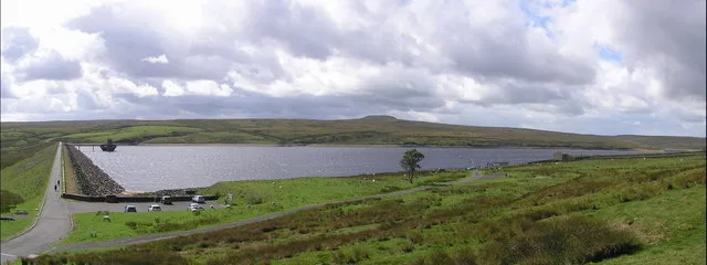
📷 3Reservoirs & lochs · North East England
Burnhope Reservoir
Burnhope Reservoir — lake in the United Kingdom.
📷 3Historic houses · North East England
Former Limekiln
Former Limekiln — a historic house in scotland-lowlands, United Kingdom.
📷 5Archaeological sites · North East England
Former Limekiln
Former Limekiln — archaeological in scotland lowlands.
📷 4📷 4Heritage railway stations · North East England
Wearhead railway station
Wearhead railway station in England North East, United Kingdom.
📷 5Mountains & hills · North East England
Highwatch Currick
Highwatch Currick — mountain in scotland lowlands. Elevation: 639.5 m.
Where to eat & stay near Far High House Meadows
Places to stay
📷 5Caravan parks · North East England
Gate House Cottage Caravan Site
Gate House Cottage Caravan Site — a caravan park in scotland lowlands.
 📷 5
📷 5Campsites · North East England
Pennine Lodge
Pennine Lodge — a campsite in scotland lowlands.
 📷 5
📷 5Caravan parks · North East England
Country Style Holiday Home Park
Country Style Holiday Home Park — a caravan park in scotland lowlands.
 📷 5
📷 5Campsites · North East England
Killhope Lead Mining Museum Yurts
Killhope Lead Mining Museum Yurts — a campsite in scotland lowlands.
 📷 5
📷 5Caravan parks · North East England
Westgate Caravan Park and Camping Site
Westgate Caravan Park and Camping Site — a caravan park in scotland lowlands.
 📷 5
📷 5Hotels · North East England
Westgate Manor
Westgate Manor — a hotel in scotland lowlands.
Places to eat & drink
 📷 5
📷 5Historic pubs · North East England
The Lord Crewe Arms Hotel
The Lord Crewe Arms Hotel in Scotland Lowlands, United Kingdom.
 📷 5
📷 5Cafés · North East England
The White Monk Tearoom
The White Monk Tearoom — a café in scotland lowlands.
 📷 5
📷 5 📷 5
📷 5Historic pubs · North East England
Travellers' Rest Inn
Travellers' Rest Inn in Scotland Lowlands, United Kingdom.
 📷 5
📷 5Historic pubs · North East England
Black Bull Public House
Black Bull Public House in Scotland Lowlands, United Kingdom.
 📷 5
📷 5Historic pubs · North East England
1, Scattergate
1, Scattergate in England North East, United Kingdom.
More places in this region
 📷 2
📷 2Reservoirs & lochs · North East England
Balderhead Reservoir
Balderhead Reservoir — reservoir in County Durham, England, UK.
 📷 3
📷 3Reservoirs & lochs · North East England
Blackton Reservoir
Blackton Reservoir — reservoir in County Durham, England, UK.
 📷 5
📷 5Reservoirs & lochs · North East England
Grassholme Reservoir
Grassholme Reservoir — reservoir in County Durham, England, UK.
 📷 3
📷 3Reservoirs & lochs · North East England
Hury Reservoir
Hury Reservoir — reservoir in County Durham, England, UK.
Frequently asked questions
- Where is Far High House Meadows?
- Far High House Meadows is in North-East England, United Kingdom (postcode DL13 1DJ), in the parish of Stanhope.
- What is Far High House Meadows?
- Far High House Meadows in England North East, United Kingdom.
- How do I get to Far High House Meadows?
- Drivers can use postcode DL13 1DJ.
- When was Far High House Meadows built?
- Built or established in 1990.
- Is Far High House Meadows a protected site?
- Yes — Far High House Meadows is part of the Far High House Meadows SSSI Site of Special Scientific Interest and the North Pennines National Landscape (AONB).
- Is Far High House Meadows free to visit?
- Yes, Far High House Meadows is free to enter.
- How do I get to Far High House Meadows?
- Drivers can navigate to postcode DL13 1DJ. It sits within the Bishop Auckland parliamentary constituency.