
Natural landmarks · Northern Ireland
Falls Road
Also known as: Bóthar na bhFál
In or near Belfast.
Falls Road in Northern Ireland, United Kingdom.

Eric Jones — CC BY-SA 2.0 via Wikimedia Commons licence

Plan your visit
- Typical visit
- 1 h–2 h
- Nearest railway station
- Belfast Grand Central · 1.2 km
- Free entry
- Dog-friendly
About
Falls Road is a place of interest in Northern Ireland, United Kingdom — drawn from open-data sources for visitor reference. See the linked Wikipedia article for the full description.
Photo gallery
See it from the streetimagery from 2025
Imagery © Mapillary contributors, CC BY-SA 4.0
From the Wikipedia article
The Falls Road (from Irish túath na bhFál 'territory of the enclosures') is the main road through West Belfast, Northern Ireland, running from Divis Street in Belfast City Centre to Andersonstown in the suburbs. The name has been synonymous for at least a century and a half with the Catholic community in the city. The road is usually referred to as the Falls Road, rather than as Falls Road. It is known in Irish as the Bóthar na bhFál and as the Faas Raa in Ulster-Scots.
Excerpt from Wikipedia under CC BY-SA 4.0. See the source article linked in Sources below.
Background
History
The Falls Road derives its name from the Irish túath na bhFál, an Irish petty kingdom whose name means "territory of the enclosures". All of these mills have now closed or have been repurposed. This original area, which was centred on the junction of modern-day Millfield and College Avenue on what is now Divis Street, was known as Falls and lent its name to the road. which had previously been called The Pound. The housing in the area developed in the 19th century and was organised in narrow streets of small terraced housing. The Westlink linking the M1 and M2 motorways now cuts through this area.
Description
In the late 1960s, many Catholics from across Northern Ireland began to campaign, many with Northern Ireland Civil Rights Association (NICRA), against discrimination in housing and jobs, under the banner of a civil rights campaign, in conscious imitation of the philosophy of, and tactics used by, the American Civil Rights Movement. Northern Ireland was part of the UK but the voting criteria were different to England, Scotland and Wales where a person could vote as soon as they became 18 years old. In Northern Ireland an 18-year-old could only vote if they were the named owner or named renter of a house. Most of the Catholic houses had three generations living in the same dwelling (because…
Sourced from Wikipedia under CC BY-SA 4.0.
- Coordinates
- 54.5935, -5.9582
- District
- Belfast
- Postcode
- BT12 6AF
- Parliamentary constituency
- Belfast West
- Nearest railway station
- Belfast Grand Central — 1.2 km
Sources
- wikidata: Q1394714 (CC0)
- wikipedia: Falls Road, Belfast (CC BY-SA 4.0)
Other places nearby
St Dominic's Grammar School for Girls
Historic churches · 0.1 km
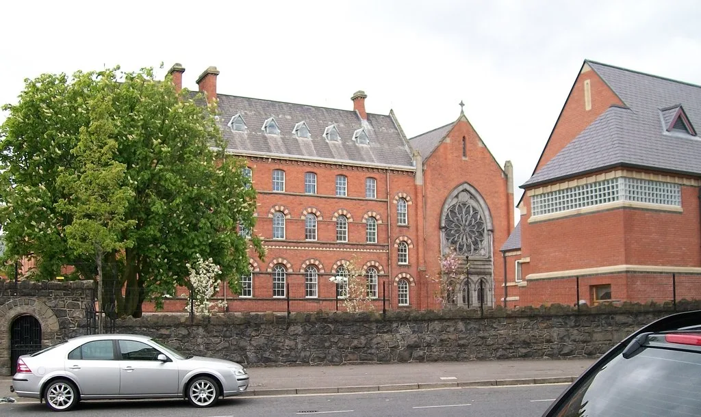
Dominican Convent
Abbeys & priories · 0.1 km

St. Mary's University College
Historic churches · 0.2 km
Cultúrlann McAdam Ó Fiaich
Natural landmarks · 0.2 km
An Ceathrú Póilí
Natural landmarks · 0.2 km

Royal Jubilee Maternity Hospital
Natural landmarks · 0.2 km
Belfast Asylum
Natural landmarks · 0.2 km

Royal Belfast Hospital for Sick Children
Natural landmarks · 0.3 km

Féile an Phobail
Other places · 0.3 km
Belfast Cineplex
Theatres · 0.3 km

Royal Victoria Hospital, Belfast
Natural landmarks · 0.3 km
Gaeltacht Quarter
Natural landmarks · 0.3 km
Nearby
📷 3Historic churches · Northern Ireland
St Dominic's Grammar School for Girls
St Dominic's Grammar School for Girls in Northern Ireland, United Kingdom.
📷 3Abbeys & priories · Northern Ireland
Dominican Convent
Dominican Convent — convent in Belfast, County Antrim, Northern Ireland.
📷 4Historic churches · Northern Ireland
St. Mary's University College
St. Mary's University College in Northern Ireland, United Kingdom.
📷 4Natural landmarks · Northern Ireland
Cultúrlann McAdam Ó Fiaich
Cultúrlann McAdam Ó Fiaich in Northern Ireland, United Kingdom.
📷 3Natural landmarks · Northern Ireland
An Ceathrú Póilí
An Ceathrú Póilí in Northern Ireland, United Kingdom.
📷 4Natural landmarks · Northern Ireland
Royal Jubilee Maternity Hospital
Royal Jubilee Maternity Hospital in Northern Ireland, United Kingdom.
Where to eat & stay near Falls Road
Places to stay
 📷 5
📷 5Hostels · Northern Ireland
Paddy's Palace Belfast
Paddy's Palace Belfast — a hostel in northern ireland.
📷 5Hostels · Northern Ireland
Botanical Backpackers
Botanical Backpackers — a hostel in northern ireland.
 📷 5
📷 5Hostels · Northern Ireland
Belfast International Youth Hostel
Belfast International Youth Hostel — a hostel in northern ireland.
 📷 5
📷 5Hostels · Northern Ireland
Vagabonds Belfast Hostel
Vagabonds Belfast Hostel — a hostel in northern ireland.
.JPG?width=1200)
 📷 7
📷 7Hotels · Northern Ireland
DoubleTree by Hilton Belfast City Ten Square
DoubleTree by Hilton Belfast City Ten Square — a hotel in northern ireland. Brand: DoubleTree.
Places to eat & drink
 📷 7
📷 7Historic pubs · Northern Ireland
Crown Liquor Saloon
Crown Liquor Saloon in Northern Ireland, United Kingdom.
 📷 7
📷 7Historic pubs · Northern Ireland
Kelly's Cellars
Kelly's Cellars in Northern Ireland, United Kingdom.
 📷 5
📷 5 📷 5
📷 5 📷 5
📷 5 📷 3
📷 3Historic pubs · Northern Ireland
Red Lion Pub bombing
Red Lion Pub bombing in Northern Ireland, United Kingdom.
More natural landmarks in this region
 Flagship📷 4
Natural landmarks · Northern Ireland
Lough Erne
Lough Erne — lake in County Fermanagh, Northern Ireland, UK.
 Flagship📷 4
Natural landmarks · Northern Ireland
Lough Neagh
Lough Neagh — large lake in Northern Ireland.
 📷 3
📷 3Natural landmarks · Northern Ireland
Ballysaggart Lough
Ballysaggart Lough — lake in the United Kingdom.
 📷 5
📷 5Natural landmarks · Northern Ireland
Belmore Mountain
Belmore Mountain — mountain in the United Kingdom.
Frequently asked questions
- Where is Falls Road?
- Falls Road is in Northern Ireland, United Kingdom (postcode BT12 6AF).
- What is Falls Road?
- Falls Road in Northern Ireland, United Kingdom.
- How do I get to Falls Road?
- The nearest railway station is Belfast Grand Central, about 1.2 km away. Drivers can use postcode BT12 6AF.
- Is Falls Road free to visit?
- Yes, Falls Road is free to enter.
- How do I get to Falls Road?
- The nearest railway station is Belfast Grand Central, about 1.2 km away. Drivers can navigate to postcode BT12 6AF.