
Mountains & hills · North West England
Fair Snape Fell
In or near Dunsop Bridge.
Fair Snape Fell — Named summit at 520 m.

Wikimedia Commons contributors — see linked file page for photographer and licence licence

Plan your visit
- Typical visit
- 3 h–8 h
- Best time of year
- Late spring – early autumn (May–Oct)
- Free entry
- Dog-friendly
About
Fair Snape Fell is a named summit in the United Kingdom. Wikidata describes it as: "Named summit at 520 m.". Coordinates: 53.9196°, -2.6147°.
Photo gallery
Protected designations
- Site of Special Scientific Interest: Bowland Fells SSSI
- Area of Outstanding Natural Beauty: Forest Of Bowland
Designations sourced from Natural England open data under OGL v3.
From the Wikipedia article
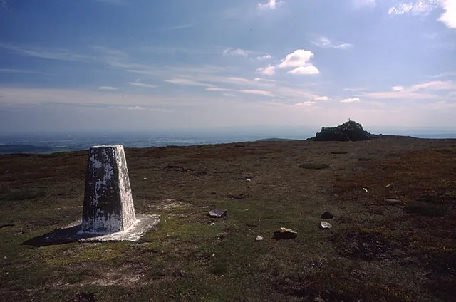
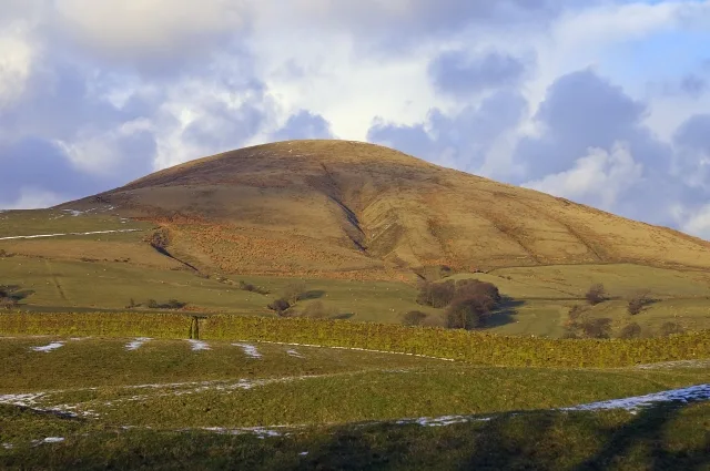
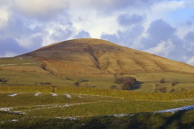
Fair Snape Fell is one of the larger hills in the Forest of Bowland in Lancashire, England. It reaches 521.9 m (1,712 ft) with a prominence of 226.2 m (742 ft) and is classed as a Marilyn. It occupies a position in the very south of the main range of fells, alongside and just to the north of Parlick, to which it is joined by a ridge. The main paths approach the summit from Parlick in the south, Saddle Fell in the east and Bleasdale in the valley to the west. The Saddle Fell approach is as boggy as the hills to the north. The summit is covered in grass and peat groughs. A trig point and large cairn occupy the top of the western escarpment, with the highest point being about 700 metres (770 yd) to the north-east. The word snape means "pasture"; thus Fair Snape Fell means "fell of the fair (beautiful) pasture". Considerable areas of the Bowland fells were used for military training during World War II and there are still unexploded bombs in some areas, including nearby Wolf Fell.
Excerpt from Wikipedia under CC BY-SA 4.0. See the source article linked in Sources below.
- Coordinates
- 53.9196, -2.6147
- Address
- Lancashire, England
Sources
- osm: n29517111 (ODbL)
- wikipedia: Fair Snape Fell (CC BY-SA 4.0)
- commons: Paddy's Pole from the trig point on Fair Snape Fell - geograph.org.uk - 991457.jpg (CC BY-SA 4.0)
Other places nearby
Fair Snape Fell
Natural landmarks · 0.0 km

Paddy's Pole
Mountains & hills · 0.8 km

Holme House Fell
Mountains & hills · 2.1 km
Parlick
Natural landmarks · 2.2 km
Parlick
Mountains & hills · 2.2 km

Fiendsdale
Mountains & hills · 2.3 km

Bleasdale Timber Circle
Archaeological sites · 2.4 km

Bleasdale Timber Circle
Archaeological sites · 2.4 km
Hazelhurst Fell
Mountains & hills · 3.0 km

Hareden Fell
Mountains & hills · 3.2 km

Hazelhurst Fell
Mountains & hills · 3.5 km

Greave Clough Head
Mountains & hills · 3.9 km
Nearby
📷 5Natural landmarks · North West England
Fair Snape Fell
Fair Snape Fell — mountain in the United Kingdom.
📷 5Mountains & hills · North West England
Paddy's Pole
Paddy's Pole — mountain in england north west. Elevation: 510 m.
📷 5Mountains & hills · North West England
Holme House Fell
Holme House Fell — mountain in england north west. Elevation: 459 m.
📷 5📷 5📷 5Mountains & hills · North West England
Fiendsdale
Fiendsdale — mountain in england north west. Elevation: 433 m.
Where to eat & stay near Fair Snape Fell
Places to stay
 📷 5
📷 5Hostels · North West England
Clark House Camping Barn
Clark House Camping Barn — a hostel in england north west.
 📷 5
📷 5Caravan parks · North West England
Brickhouse Caravan Site
Brickhouse Caravan Site — a caravan park in england north west.
 📷 5
📷 5Campsites · North West England
Waddecar Scout Camp
Waddecar Scout Camp — a campsite in england north west.
 📷 5
📷 5 📷 5
📷 5Campsites · North West England
Fell view
Fell view — a campsite in england north west.
 📷 5
📷 5Caravan parks · North West England
Horns Inn Caravan Club CL
Horns Inn Caravan Club CL — a caravan park in england north west.
Places to eat & drink
 📷 5
📷 5Restaurants · North West England
The Inn at Whitewell
The Inn at Whitewell — a restaurant in england north west.
📷 5Historic pubs · North West England
Ye Horns Inn
Ye Horns Inn in England North West, United Kingdom.
 📷 5
📷 5Restaurants · North West England
The Three Fishes
The Three Fishes — a restaurant in england north west.
 📷 5
📷 5Historic pubs · North West England
The Stork
The Stork — Historic pub — listed building or notable heritage status.
 📷 5
📷 5Historic pubs · North West England
Swan with Two Necks
Swan with Two Necks in England North West, United Kingdom.
 📷 7
📷 7Historic pubs · North West England
Moor Park Hotel
Moor Park Hotel in England North West, United Kingdom.
More mountains in this region
 📷 5
📷 5Mountains & hills · North West England
Appleton Park
Appleton Park — a hill or mountain in england west midlands.
 📷 5
📷 5Mountains & hills · North West England
High Warren
High Warren — mountain in england west midlands. Elevation: 105 m.
 📷 5
📷 5Mountains & hills · North West England
Alderley Edge
Alderley Edge — mountain in england west midlands. Elevation: 194 m.
 📷 3
📷 3Frequently asked questions
- Where is Fair Snape Fell?
- Fair Snape Fell is in North-West England, United Kingdom.
- What is Fair Snape Fell?
- Fair Snape Fell — Named summit at 520 m.
- How do I get to Fair Snape Fell?
- The nearest town is Dunsop Bridge. Its coordinates are 53.9196°, -2.6147°.
- Is Fair Snape Fell a protected site?
- Yes — Fair Snape Fell is part of the Bowland Fells SSSI Site of Special Scientific Interest and the Forest Of Bowland National Landscape (AONB).
- Is Fair Snape Fell free to visit?
- Yes, Fair Snape Fell is free to enter.