
Towns & cities · South East England
Everleigh
Everleigh — village and civil parish in west Wiltshire, England.

Wikimedia Commons contributors — see linked file page for photographer and licence licence

Plan your visit
- Typical visit
- 3 h–6 h
- Nearest railway station
- Pewsey · 7.9 km
- Free entry
- Family-friendly
- Dog-friendly
Getting there & planning your visit
To visit Everleigh, the nearest railway station is Pewsey, located 7.9 km away. Entry to the town is free.
About
Everleigh is a town, city, village or settlement in the United Kingdom. Recent population estimates put it at around 209 people. Address: SN8. Wikidata describes it as: "village and civil parish in west Wiltshire, England". Coordinates: 51.2830°, -1.7089°.
Photo gallery
Official information
Everleigh is a small village located on the North East edge of Salisbury Plain in Wiltshire. It has historical connections to royalty and notable figures, as well as archaeological significance. The village serves as a site for military activities and offers a glimpse into local governance through its active Parish Council.
Protected designations
- Site of Special Scientific Interest: River Avon System SSSI
- Site of Special Scientific Interest: Salisbury Plain SSSI
- Area of Outstanding Natural Beauty: North Wessex Downs
Designations sourced from Natural England open data under OGL v3.
From the Wikipedia article
Everleigh, pronounced and also sometimes spelled Everley, is a village and civil parish in east Wiltshire, England, about 4+1⁄2 miles (7 km) southeast of the town of Pewsey, towards the northeast of Salisbury Plain. The village is also known as East Everleigh, to distinguish it from the hamlet of Lower Everleigh which lies about 1 mile (1.6 km) further west on the A342 road that connects Andover and Devizes. The village is surrounded by land known as Everleigh Drop Zone, owned by the Ministry of Defence that is used for military training as part of the Salisbury Plain Training Area.
Excerpt from Wikipedia under CC BY-SA 4.0. See the source article linked in Sources below.
Background
History
The partly-forested area was known for recreational hunting. By the 13th century there was a deer park and a rabbit warren, and later activities included hare coursing, falconry and racehorse training. East Everleigh developed at a crossroads where the old Marlborough-Salisbury road (now only a track in the south of the parish) met the Devizes-Andover road (now the A342). In the 18th and 19th centuries, several inns provided refreshment and lodging. The Everleigh estate was bought by Sir John Astley in 1765, and inherited in 1771 by his cousin Francis Dugdale Astley; it continued as the seat of the Astley baronets until the middle of the next century. Sir Francis made changes to the village…
Sourced from Wikipedia under CC BY-SA 4.0.
- Coordinates
- 51.2830, -1.7089
- District
- Wiltshire
- Parish
- Everleigh
- Postcode
- SN8
- Parliamentary constituency
- East Wiltshire
- Population
- 209
- Nearest railway station
- Pewsey — 7.9 km
- Official site
- www.everleigh.org
Sources
- wikidata: Q1962575 (CC0)
- wikipedia: Everleigh, Wiltshire (CC BY-SA 4.0)
- commons: Everleigh - The Crown Hotel - geograph.org.uk - 1459858.jpg (CC BY-SA 4.0)
Other places nearby

Everleigh Manor
Manor houses · 0.2 km
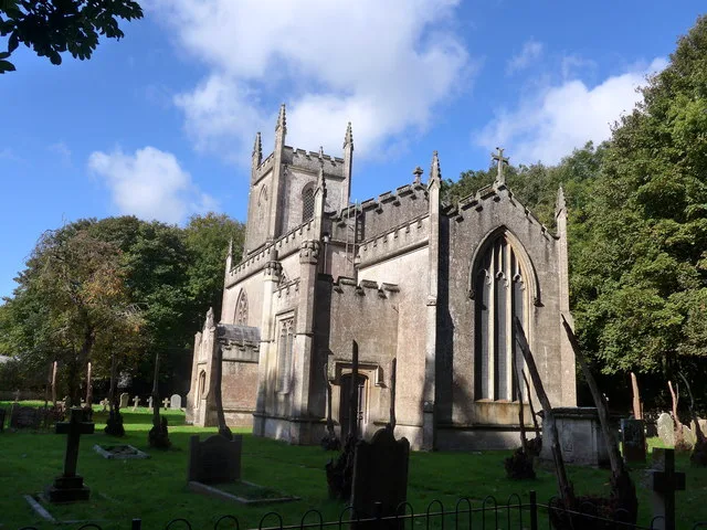
St Peter's Church, Everleigh
Historic churches · 0.7 km

Round Down
Mountains & hills · 1.6 km

Weather Hill
Mountains & hills · 2.0 km

Sidbury Hill
Mountains & hills · 3.4 km

Sidbury Hill
Mountains & hills · 3.5 km
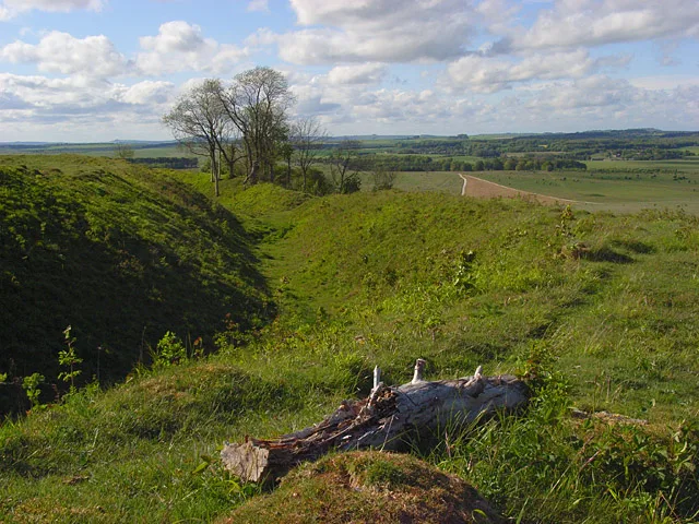
Sidbury Camp
Hill forts · 3.5 km

Sunton
Vineyards · 3.5 km

Inham Down
Mountains & hills · 3.5 km

Sidbury Hill Fort
Hill forts · 3.5 km

Twin Barrows
Archaeological sites · 3.6 km

Lindbury Camp
Archaeological sites · 3.7 km
Everleigh is a charming town located in South East England. Visitors can explore historic sites such as St Peter's Church, Everleigh and Everleigh Manor. The area also offers scenic walks around Sidbury Hill Fort and the nearby Twin Barrows.
At a glance
- Population
- 209
- Constituency
- East Wiltshire
- Top categories near here
Things to see in Everleigh
10 attractions within 12 km. Full guide: things to do in Everleigh →
📷 5📷 5Historic churches · South East England
St Peter's Church, Everleigh
St Peter's Church, Everleigh — church in Everleigh, Wiltshire, England, UK.
📷 5Hill forts · South East England
Sidbury Hill Fort
Sidbury Hill Fort — a hill fort in england-south-east, United Kingdom.
📷 5Archaeological sites · South East England
Twin Barrows
Twin Barrows — a archaeological in england-south-east, United Kingdom.
📷 5Manor houses · South East England
Everleigh Manor
Everleigh Manor — Grade II listed building-listed manor in england-south-east, United Kingdom.
📷 5Mountains & hills · South East England
Sidbury Hill
Sidbury Hill — a hill or mountain in england south east.
📷 5Mountains & hills · South East England
Weather Hill
Weather Hill — mountain in england south east. Elevation: 171 m.
📷 5Mountains & hills · South East England
Sidbury Hill
Sidbury Hill — mountain in england south east. Elevation: 224 m.
 📷 5
📷 5Mountains & hills · South East England
Dunch Hill
Dunch Hill — mountain in england south east. Elevation: 165 m.
📷 5Mountains & hills · South East England
Round Down
Round Down — mountain in england south east. Elevation: 190 m.
Nearby
📷 5Manor houses · South East England
Everleigh Manor
Everleigh Manor — Grade II listed building-listed manor in england-south-east, United Kingdom.
📷 5Historic churches · South East England
St Peter's Church, Everleigh
St Peter's Church, Everleigh — church in Everleigh, Wiltshire, England, UK.
📷 5Mountains & hills · South East England
Round Down
Round Down — mountain in england south east. Elevation: 190 m.
📷 5Mountains & hills · South East England
Weather Hill
Weather Hill — mountain in england south east. Elevation: 171 m.
📷 5Mountains & hills · South East England
Sidbury Hill
Sidbury Hill — a hill or mountain in england south east.
📷 5Mountains & hills · South East England
Sidbury Hill
Sidbury Hill — mountain in england south east. Elevation: 224 m.
Where to eat & stay near Everleigh
Places to stay
 📷 5
📷 5Campsites · South East England
The Bruce Arms Campsite
The Bruce Arms Campsite — a campsite in england south east.
 📷 5
📷 5Campsites · South East England
The Woodbridge Camp SIte
The Woodbridge Camp SIte — a campsite in england south east.
 📷 5
📷 5Campsites · South East England
Totteridge Farm
Totteridge Farm — a campsite in england south east.
 📷 5
📷 5Caravan parks · South East England
Charlton Manor
Charlton Manor — a caravan park in england south east.
 📷 5
📷 5Campsites · South East England
Thruxton Circuit Camp Site
Thruxton Circuit Camp Site — a campsite in england south east.
 📷 5
📷 5Hostels · South East England
Cholderton Youth Hostel
Cholderton Youth Hostel — a hostel in england south east.
Places to eat & drink
 📷 5
📷 5 📷 5
📷 5Historic pubs · South East England
The Cricketer's Arms
The Cricketer's Arms in England South East, United Kingdom.
 📷 5
📷 5Historic pubs · South West England
The Greyhound Tavern
The Greyhound Tavern in England South West, United Kingdom.
 📷 5
📷 5 📷 5
📷 5Historic pubs · South West England
Malet Arms
Malet Arms in England South West, United Kingdom.
 📷 5
📷 5Historic pubs · South East England
The Black Swan Public House
The Black Swan Public House in England South East, United Kingdom.
More towns in this region
 Flagship📷 10
Towns & cities · South East England
Betchworth
Betchworth — village and civil parish in the Mole Valley district of Surrey, England.
 Flagship📷 10
Towns & cities · South East England
Boxley
Boxley — village and civil parish in Maidstone District, Kent, England, UK.
 Flagship📷 10
Towns & cities · South East England
Effingham
Effingham — village and civil parish in Guildford borough, Surrey, England, UK.
 Flagship📷 10
Towns & cities · South East England
Englefield Green
Englefield Green — village in the borough of Runnymede, Surrey, UK.
Frequently asked questions
- Where is Everleigh?
- Everleigh is in South-East England, United Kingdom (postcode SN8), in the parish of Everleigh.
- What is Everleigh?
- Everleigh — village and civil parish in west Wiltshire, England.
- How do I get to Everleigh?
- The nearest railway station is Pewsey, about 7.9 km away. Drivers can use postcode SN8.
- Is Everleigh a protected site?
- Yes — Everleigh is part of the River Avon System SSSI Site of Special Scientific Interest and the Salisbury Plain SSSI Site of Special Scientific Interest.
- Is Everleigh free to visit?
- Yes, Everleigh is free to enter.
- How do I get to Everleigh?
- The nearest railway station is Pewsey, about 7.9 km away. Drivers can navigate to postcode SN8.