Natural landmarks · North West England
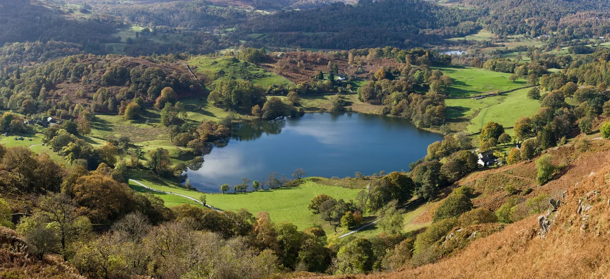
Elter Water
In or near Elterwater.
Elter Water — lake in the United Kingdom.

Wikimedia Commons contributors — see linked file page for photographer and licence licence
Plan your visit
- Typical visit
- 1 h–2 h
- Nearest railway station
- Windermere · 9.6 km
- Free entry
- Dog-friendly
Getting there & planning your visit
To visit Elter Water, the nearest railway station is Windermere, located 9.6 km away. The postcode for navigation is LA22 9HL. Entry to the site is free.
About
Elter Water is a named natural landmark in the United Kingdom. Heritage designation: Site of Special Scientific Interest. Wikidata describes it as: "lake in the United Kingdom". Coordinates: 54.4275°, -3.0259°.
Photo gallery
Protected designations
- Site of Special Scientific Interest: Elterwater SSSI
- Site of Special Scientific Interest: River Eden and Tributaries SSSI
Designations sourced from Natural England open data under OGL v3.
From the Wikipedia article
Elter Water is a small lake in the Lake District in North West England, half a mile southeast of the village of the same name. It has a length of 0.62 miles (1.00 km), maximum width of approximately 0.24 miles (0.39 km), a maximum depth of 7 metres (7.7 yd), and an area of 0.16 square kilometres (0.062 sq mi). Its outflow is the River Brathay, which flows south to join Windermere near Ambleside. Windermere is itself drained by the River Leven, which flows into Morecambe Bay. The lake is in the unitary authority of Westmorland and Furness and the ceremonial county of Cumbria. Elter Water forms part of the boundary between the historic counties of Lancashire and Westmorland, and is the northernmost point of the former.
Excerpt from Wikipedia under CC BY-SA 4.0. See the source article linked in Sources below.
- Coordinates
- 54.4275, -3.0259
- District
- Westmorland and Furness
- Parish
- Lakes
- Postcode
- LA22 9HL
- Parliamentary constituency
- Westmorland and Lonsdale
- Nearest railway station
- Windermere — 9.6 km
Sources
- wikidata: Q1543979 (CC0)
- wikipedia: Elter Water (CC BY-SA 4.0)
- commons: Elterwater and Langdale.jpg (CC BY-SA 4.0)
Other places nearby

Little Loughrigg
Mountains & hills · 0.8 km
Little Loughrigg
Mountains & hills · 0.8 km

Skelwith Force
Waterfalls · 0.9 km
Loughrigg Tarn
Natural landmarks · 1.0 km

Elterwater Hostel
Hostels · 1.0 km

Elterwater Bridge
Historic bridges · 1.1 km

Elterwater
Towns & cities · 1.1 km

Skelwith Bridge (That Part Within Lakes District)
Historic bridges · 1.1 km

Tarn Foot Farm Campsite
Campsites · 1.2 km

Colwith Force
Waterfalls · 1.2 km

The Fort
Historic houses · 1.2 km

YHA Langdale
Hostels · 1.3 km
Nearby
📷 5Mountains & hills · North West England
Little Loughrigg
Little Loughrigg — a hill or mountain in england north west.
📷 5Mountains & hills · North West England
Little Loughrigg
Little Loughrigg — mountain in england north west. Elevation: 155 m.
📷 5📷 3Natural landmarks · North West England
Loughrigg Tarn
Loughrigg Tarn — lake in the Lake District, Cumbria, England.
📷 5Hostels · North West England
Elterwater Hostel
Elterwater Hostel — a hostel in england north west.
📷 4Historic bridges · North West England
Elterwater Bridge
Elterwater Bridge is a historic bridge in the United Kingdom.
Where to eat & stay near Elter Water
Places to stay
📷 5Hostels · North West England
Elterwater Hostel
Elterwater Hostel — a hostel in england north west.
📷 5Campsites · North West England
Tarn Foot Farm Campsite
Tarn Foot Farm Campsite — a campsite in england north west.
📷 5Hostels · North West England
YHA Langdale
YHA Langdale — a hostel in england north west. Brand: Youth Hostels Association.
 📷 5
📷 5 📷 5
📷 5 📷 5
📷 5Caravan parks · North West England
Skelwith Fold Caravan Park
Skelwith Fold Caravan Park — a caravan park in england north west.
Places to eat & drink
 📷 5
📷 5Historic pubs · North West England
Golden Rule Hotel
Golden Rule Hotel in England North West, United Kingdom.
 📷 7
📷 7Historic pubs · North West England
The Travellers Rest
The Travellers Rest in England North West, United Kingdom.
 📷 5
📷 5Restaurants · North West England
Holbeck Ghyll Restaurant
Holbeck Ghyll Restaurant — a restaurant in england north west.
 📷 4
📷 4Restaurants · North West England
Holbeck Ghyll
Holbeck Ghyll is a restaurant located in Windermere, Cumbria, England. "The late 19th century building was once Lord Lonsdale's hunting lodge and only became a hotel in the 1970s. It won a Michelin st
📷 5Historic pubs · North West England
Holbeck Ghyll
Holbeck Ghyll in England North West, United Kingdom.
 📷 5
📷 5Historic pubs · North West England
Sun Cottage Sun Inn Public House
Sun Cottage Sun Inn Public House in England North West, United Kingdom.
More natural landmarks in this region
 📷 3
📷 3Natural landmarks · North West England
Statue of Oliver Cromwell
Statue of Oliver Cromwell — Public artwork (statue).
 📷 3
📷 3Natural landmarks · North West England
Dagfields Craft Centre
Dagfields Craft Centre — a other in england-west-midlands, United Kingdom.
 📷 3
📷 3Natural landmarks · North West England
Weaver Valley Cruises
Weaver Valley Cruises — a other in england-west-midlands, United Kingdom.
 📷 3
📷 3Natural landmarks · North West England
Golden Gates
Golden Gates — a other in england-west-midlands, United Kingdom.
Frequently asked questions
- Where is Elter Water?
- Elter Water is in North-West England, United Kingdom (postcode LA22 9HL), in the parish of Lakes.
- What is Elter Water?
- Elter Water — lake in the United Kingdom.
- How do I get to Elter Water?
- The nearest railway station is Windermere, about 9.6 km away. Drivers can use postcode LA22 9HL.
- Is Elter Water a listed building?
- Elter Water is officially recognised as Site of Special Scientific Interest listed.
- Is Elter Water a protected site?
- Yes — Elter Water is part of the Elterwater SSSI Site of Special Scientific Interest and the River Eden and Tributaries SSSI Site of Special Scientific Interest.
- Is Elter Water free to visit?
- Yes, Elter Water is free to enter.
- How do I get to Elter Water?
- Drivers can navigate to postcode LA22 9HL. It sits within the Westmorland and Lonsdale parliamentary constituency.