Islands · Scottish Highlands
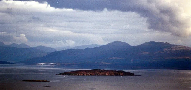
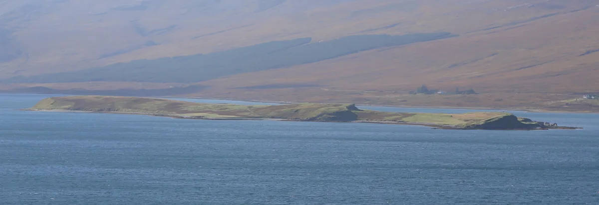
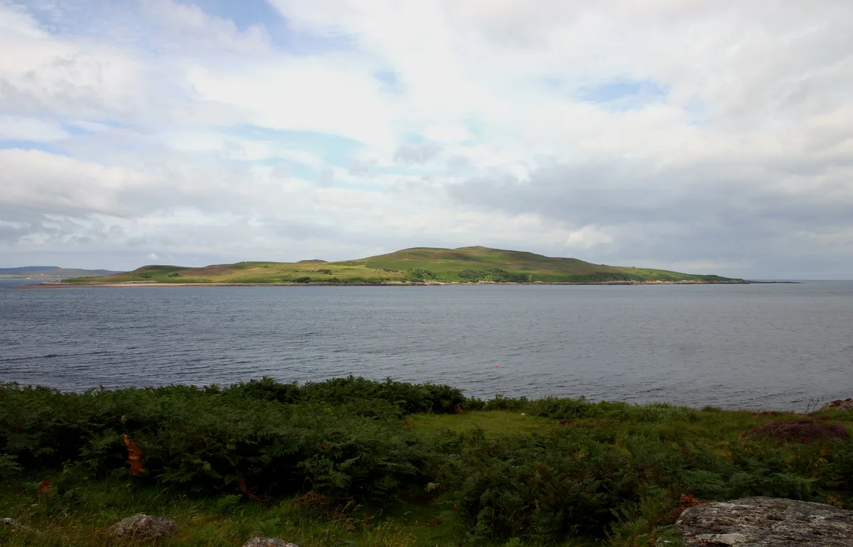
Eilean Meadhonach
In or near Kyle of Lochalsh.
Eilean Meadhonach — island in Highland, Scotland, UK.

Wikimedia Commons contributors — see linked file page for photographer and licence licence
Plan your visit
- Typical visit
- 4 h–12 h
- Nearest railway station
- Duirinish · 9.6 km
- Free entry
- Dog-friendly
Getting there & planning your visit
Eilean Meadhonach is located in the Scottish Highlands, with the nearest railway station being Duirinish, approximately 9.6 km away. Entry to the island is free.
About
Eilean Meadhonach is a island in the United Kingdom. Part of Crowlin Islands. Wikidata describes it as: "island in Highland, Scotland, UK". Coordinates: 57.3450°, -5.8451°.
Photo gallery
From the Wikipedia article
Eilean Meadhonach is the second largest of the Crowlin Islands, located in the Inner Sound off the island of Skye, Scotland. It is situated immediately to the west of Eilean Mòr, and to the north is Eilean Beag, both of which it is connected to at low tide. The total area is 77 hectares (190 acres) although Haswell-Smith also provides a figure of 50 hectares (120 acres) for the area. The larger figure may include Eilean Beag and the lower one Eilean Meadhonach alone at high tide. Crowlin Harbour is at the northern end of the 50-metre-wide (160 ft) gap between Eilean Meadhonach and Eilean Mòr and provides a natural shelter from westerly and southerly winds. It is also possible to anchor in a small pool at the centre of this strait. Excavations on Eilean Mòr have shown evidence of Mesolithic human settlement and there are the remains of a midden and rock shelter on the north west coast of Eilean Meadhonach. Eilean Mòr has ruined cottages from historic times although there is no evidence of permanent recent habitation on Eilean Meadhonach. Eilean Beag has a light beacon and the remains of an old shieling.
Excerpt from Wikipedia under CC BY-SA 4.0. See the source article linked in Sources below.
- Coordinates
- 57.3450, -5.8451
- Nearest railway station
- Duirinish — 9.6 km
Sources
- wikidata: Q5349305 (CC0)
- wikipedia: Eilean Meadhonach (CC BY-SA 4.0)
- commons: Low-tide connection between Eilean Meadhonach and Eilean Mor - geograph.org.uk - 1242162.jpg (CC BY-SA 4.0)
Other places nearby

Crowlin Islands
Islands · 0.9 km

Eilean Mòr
Islands · 1.0 km

Eilean Beag
Islands · 1.1 km

Loch Toscaig
Natural landmarks · 2.7 km

Aird Mhor
Mountains & hills · 2.9 km

Eilean na Bà
Islands · 3.2 km

Uags
Villages · 3.7 km

Carn Donnachaidh
Mountains & hills · 4.3 km
Poll Domhain
Natural landmarks · 4.6 km

Toscaig
Reservoirs & lochs · 4.7 km
Longay
Islands · 4.7 km

Toscaig
Villages · 4.8 km
Nearby
📷 5Islands · Scottish Highlands
Crowlin Islands
Crowlin Islands in Scotland Islands, United Kingdom.
📷 5Islands · Scottish Highlands
Eilean Mòr
Eilean Mòr — island of the Crowlin Islands, Highland, Scotland, UK.
📷 3Islands · Scottish Highlands
Eilean Beag
Eilean Beag — island of the Crowlin Islands, Highland, Scotland, UK.
Natural landmarks · Scottish Highlands
Loch Toscaig
Loch Toscaig — a natural feature in scotland highlands.
📷 5Mountains & hills · Scottish Highlands
Aird Mhor
Aird Mhor — a hill or mountain in scotland highlands.
📷 2Where to eat & stay near Eilean Meadhonach
Places to stay
 📷 5
📷 5Campsites · Scottish Highlands
Applecross Campsite
Applecross Campsite — a campsite in scotland highlands.
 📷 5
📷 5Hostels · Scottish Highlands
Skye Backpackers
Skye Backpackers — a hostel in scotland highlands.
 📷 5
📷 5Hostels · Scottish Highlands
Saucy Mary's Lodge
Saucy Mary's Lodge — a hostel in scotland highlands.
 📷 5
📷 5 📷 5
📷 5Caravan parks · Scottish Highlands
Duirinish Holiday Lodges
Duirinish Holiday Lodges — a caravan park in scotland highlands.
 📷 5
📷 5Hostels · Scottish Highlands
Broadford Youth Hostel
Broadford Youth Hostel — a hostel in scotland highlands. Brand: Hostelling Scotland.
More places in this region
 Flagship📷 5
Islands · Scottish Highlands
Eigg
Eigg — one of the Small Isles in the Inner Hebrides, Scotland, UK.
 Flagship📷 5
Islands · Scottish Highlands
Eilean Choraidh
Eilean Choraidh — island in Loch Eriboll, Sutherland, Highland, Scotland, UK.
 Flagship📷 3
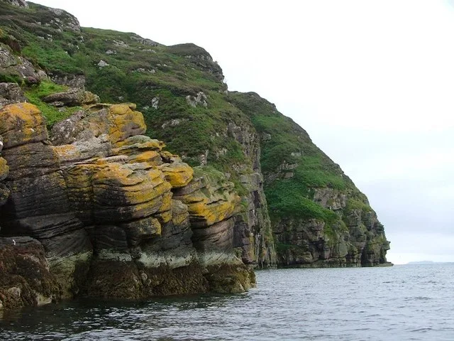 Flagship📷 5
Islands · Scottish Highlands
Isle Martin
Isle Martin — island in Highland, Scotland, UK.
Frequently asked questions
- Where is Eilean Meadhonach?
- Eilean Meadhonach is in the Scottish Highlands, United Kingdom.
- What is Eilean Meadhonach?
- Eilean Meadhonach — island in Highland, Scotland, UK.
- How do I get to Eilean Meadhonach?
- The nearest railway station is Duirinish, about 9.6 km away. Its coordinates are 57.3450°, -5.8451°.
- Is Eilean Meadhonach free to visit?
- Yes, Eilean Meadhonach is free to enter.