
Islands · Scottish Islands
East Burra
In or near Hamnavoe.
East Burra — one of the Scalloway Islands, a subgroup of the Shetland Islands in Scotland.

Wikimedia Commons contributors — see linked file page for photographer and licence licence

Plan your visit
- Typical visit
- 4 h–12 h
- Free entry
- Dog-friendly
Getting there & planning your visit
East Burra is located in the Shetland Islands, with the postcode ZE2 9JT. Entry to the island is free. There is no nearest railway station due to its remote location.
About
East Burra is a island in the United Kingdom. It covers approximately 515 km². Recent population estimates put it at around 76 people. Part of Shetland Islands. Wikidata describes it as: "one of the Scalloway Islands, a subgroup of the Shetland Islands in Scotland". Coordinates: 60.0889°, -1.3017°.
Photo gallery
From the Wikipedia article
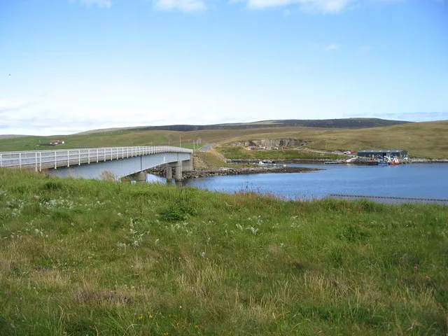
East Burra (Old Norse: Barrey) is one of the Scalloway Islands, a subgroup of the Shetland Islands in Scotland. It is connected by a bridge to West Burra. With an area of 515 hectares (1,273 acres) it is the twelfth largest of the Shetland Islands. East Burra has a much smaller population than West Burra and no substantial settlement; rather, there are a few hamlets and a scattering of individual croft houses. It is known for its Neolithic remains including a burnt mound, and for sea caves. The roofless, plain, Old Haa (manor or laird's house) of Houss is a prominent feature. From Houss, it is possible to walk the two kilometres or so across Houss Ness to the cliffs at the southern end of the island. From there, the island of South Havra, nowadays home only to sheep and seabirds, can be clearly seen. East Burra is linked to the Shetland Mainland via West Burra and Trondra by a series of bridges.
Excerpt from Wikipedia under CC BY-SA 4.0. See the source article linked in Sources below.
- Coordinates
- 60.0889, -1.3017
- District
- Shetland Islands
- Postcode
- ZE2 9JT
- Parliamentary constituency
- Orkney and Shetland
- Population
- 76
Sources
- wikidata: Q1277762 (CC0)
- wikipedia: East Burra (CC BY-SA 4.0)
- commons: View from south end of East Burra Shetland.jpg (CC BY-SA 4.0)
Other places nearby

Easter Heog
Mountains & hills · 0.2 km
Wester Heog
Mountains & hills · 0.5 km

Grevis Field
Mountains & hills · 1.0 km

Brough Hill
Mountains & hills · 1.6 km

Burra
Historic bridges · 1.9 km
Scalloway Islands
Historic bridges · 1.9 km

Muskna Field
Mountains & hills · 2.0 km
Muskna Field
Mountains & hills · 2.0 km

Meal Beach
Beaches · 2.0 km

Wester Quarff
Villages · 2.2 km

Burra Parish Church, West Burra
Historic churches · 2.2 km
West Burra
Islands · 2.5 km
Nearby
📷 5Mountains & hills · Scottish Islands
Easter Heog
Easter Heog — mountain in scotland islands. Elevation: 81 m.
📷 5Mountains & hills · Scottish Islands
Wester Heog
Wester Heog — mountain in scotland islands. Elevation: 65 m.
📷 5Mountains & hills · Scottish Islands
Grevis Field
Grevis Field — mountain in scotland islands. Elevation: 53 m.
📷 5Mountains & hills · Scottish Islands
Brough Hill
Brough Hill — a hill or mountain in scotland islands.
📷 4📷 4Historic bridges · Scottish Islands
Scalloway Islands
Scalloway Islands in Orkney + Shetland, United Kingdom.
Where to eat & stay near East Burra
Places to stay
 📷 5
📷 5Caravan parks · Scottish Islands
Cunningsburgh Touring Park
Cunningsburgh Touring Park — a caravan park in scotland islands.
 📷 5
📷 5Caravan parks · Scottish Islands
Scalloway Caravan Park
Scalloway Caravan Park — a caravan park in scotland islands.
 📷 5
📷 5Hostels · Scottish Islands
Islesburgh House Hostel
Islesburgh House Hostel — a hostel in scotland islands.
Caravan parks · Scottish Islands
Bressay Marina & Caravan Park
Bressay Marina & Caravan Park — a caravan park in scotland islands.
 📷 5
📷 5Campsites · Scottish Islands
Levenwick Campsite
Levenwick Campsite — a campsite in scotland islands.
 📷 5
📷 5Campsites · Scottish Islands
Skeld Caravan Park and Campsite
Skeld Caravan Park and Campsite — a campsite in scotland islands.
Places to eat & drink
 📷 7
📷 7Historic pubs · Scottish Islands
86 Commercial Street, Lerwick
86 Commercial Street, Lerwick in England South East, United Kingdom.
More places in this region
 📷 5
📷 5Islands · Scottish Islands
Bac Beag
Bac Beag — Scottish island, part of the Treshnish Isles in the Inner Hebrides.
 📷 5
📷 5Islands · Scottish Islands
Bac Mòr
Bac Mòr — island in Argyll and Bute, Scotland, UK, one of the Treshnish Isles.
 Flagship📷 3
Islands · Scottish Islands
Baleshare
Baleshare — flat tidal island in the Outer Hebrides, Scotland, UK.
 Flagship📷 5
Islands · Scottish Islands
Barra
Barra — island in Outer Hebrides, Scotland, UK.
Frequently asked questions
- Where is East Burra?
- East Burra is in the Scottish Islands, United Kingdom (postcode ZE2 9JT).
- What is East Burra?
- East Burra — one of the Scalloway Islands, a subgroup of the Shetland Islands in Scotland.
- How do I get to East Burra?
- The nearest town is Hamnavoe. Drivers can use postcode ZE2 9JT.
- Is East Burra free to visit?
- Yes, East Burra is free to enter.
- How do I get to East Burra?
- Drivers can navigate to postcode ZE2 9JT. It sits within the Orkney and Shetland parliamentary constituency.