
Archaeological sites · South West England
Duncliffe Wood
In or near Stour Provost.
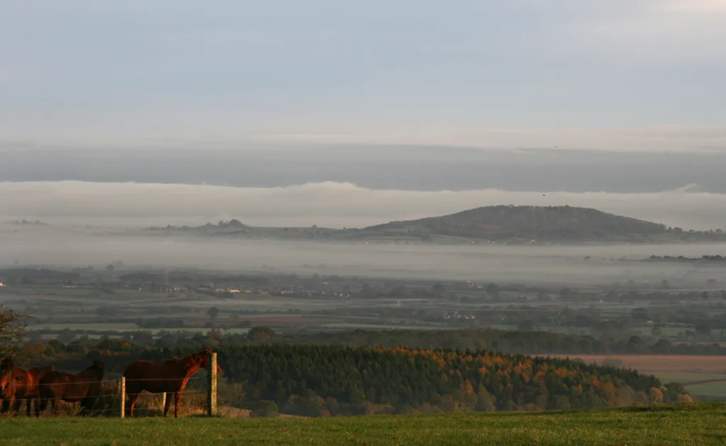
Duncliffe Wood — woodland in Dorset, England.

Wikimedia Commons contributors — see linked file page for photographer and licence licence

Plan your visit
- Typical visit
- 45 min–1.5 h
- Nearest railway station
- Gillingham · 3.9 km
- Free entry
- Dog-friendly
Getting there & planning your visit
To visit Duncliffe Wood, the nearest railway station is Gillingham, located 3.9 km away. The postcode for sat-nav is SP8 5LZ, and entry is free.
About
Duncliffe Wood is an archaeological site in the United Kingdom. Wikidata describes it as: "woodland in Dorset, England". Coordinates: 51.0016°, -2.2508°.
Photo gallery
Protected designations
- Area of Outstanding Natural Beauty: Cranborne Chase & West Wiltshire Downs
Designations sourced from Natural England open data under OGL v3.
From the Wikipedia article
Duncliffe Wood is an ancient woodland on the summit of Duncliffe Hill, a few miles west of Shaftesbury. The area of the site is 92.16 hectares (227.7 acres), making it one of the largest ancient woodlands in North Dorset. The woodland is mentioned in the Domesday Book of 1086, when it was owned by Roger de Belmont and valued at nine pounds. From there it passed into the possession of a French nunnery, until in 1414 it became a Crown property, from which it was then given to Eton College. Finally, it came into the ownership of King's College, Cambridge, in which it remained for 500 years. In 1984, the Woodland Trust—with the assistance of the Countryside Commission and local councils—acquired the site from the Forestry Commission as part of their offloading process. The woodland was traditionally coppiced until at least the 1930s, with a broad mix of native broadleaf trees—oak, ash, and hazel. During the 1960–70s, the woods were largely felled and replanted—predominantly with Norway spruce (Picea abies) and oak, with lesser amounts of Japanese larch (Larix kaempferi) and beech. The Woodland Trust has, since its acquisition of the site, been felling the conifers and replanting them with native broadleaves, or else leaving them as clearings to encourage wildlife. In addition, the trust is trying to protect the remains of the original ancient woodland; the lime trees (Tilia) in the wood are reputed to be some of the oldest living things in Dorset, estimated at between 600 and 1000 years old. Notable butterflies on the site are the silver-washed fritillary, white admiral and purple hairstreak.
Excerpt from Wikipedia under CC BY-SA 4.0. See the source article linked in Sources below.
- Coordinates
- 51.0016, -2.2508
- District
- Dorset
- Parish
- Stour Provost
- Postcode
- SP8 5LZ
- Parliamentary constituency
- North Dorset
- Nearest railway station
- Gillingham — 3.9 km
Sources
- wikidata: Q15215378 (CC0)
- wikipedia: Duncliffe Wood (CC BY-SA 4.0)
- commons: Duncliffe Wood - geograph.org.uk - 410884.jpg (CC BY-SA 4.0)
Other places nearby
Duncliffe Hill
Mountains & hills · 0.1 km

Shaftesbury Country Touring Park
Caravan parks · 1.3 km

Caalm Camp
Campsites · 2.2 km

East Stour
Villages · 2.5 km

Shaftesbury Castle Hill
Castles · 3.2 km

Stour Provost
Towns & cities · 3.2 km
Medieval fortified house at Castle Hill
Literary houses · 3.2 km

Stour Micro Museum
Museums · 3.2 km

Port Regis School
Natural landmarks · 3.2 km

Lamp Standard And War Memorial
Memorials & monuments · 3.3 km

Oldest House in Shaftesbury
Memorials & monuments · 3.3 km

Castle Hill
Viewpoints · 3.3 km
Nearby
📷 5📷 5Caravan parks · South West England
Shaftesbury Country Touring Park
Shaftesbury Country Touring Park — a caravan park in england south east.
📷 5Campsites · South West England
Caalm Camp
Caalm Camp — a campsite in england south east.
📷 5📷 5Castles · South West England
Shaftesbury Castle Hill
Shaftesbury Castle Hill — a castle in england south east.
📷 5Towns & cities · South West England
Stour Provost
Stour Provost — village and civil parish in Dorset, England, UK.
Where to eat & stay near Duncliffe Wood
Places to stay
📷 5Caravan parks · South West England
Shaftesbury Country Touring Park
Shaftesbury Country Touring Park — a caravan park in england south east.
📷 5Campsites · South West England
Caalm Camp
Caalm Camp — a campsite in england south east.
 📷 7
📷 7Hotels · South West England
The Grosvenor Arms
The Grosvenor Arms — a hotel in england south east.
 📷 5
📷 5Campsites · South West England
Holyrood campsite
Holyrood campsite — a campsite in england south east.
 📷 5
📷 5Campsites · South West England
Leela Fields Caravan & Camping Park
Leela Fields Caravan & Camping Park — a campsite in england south east.
 📷 7
📷 7Hotels · South West England
Royal Chase Hotel
Royal Chase Hotel — a hotel in england south east.
Places to eat & drink
 📷 5
📷 5Historic pubs · South West England
Fox And Hounds Public House
Fox And Hounds Public House in England South West, United Kingdom.
 📷 7
📷 7 📷 7
📷 7 📷 7
📷 7Historic pubs · South West England
The Benett Arms
The Benett Arms in England South West, United Kingdom.
 📷 7
📷 7Historic pubs · South West England
The Talbot at Iwerne Minster
The Talbot at Iwerne Minster in England South West, United Kingdom.
 📷 7
📷 7Historic pubs · South West England
The White Hart Hotel
The White Hart Hotel in England South West, United Kingdom.
More archaeological sites in this region
 📷 5
📷 5Archaeological sites · South West England
Battlesbury Camp Monuments: hillfort, settlement, cemetery, barrows, enclosure, and field systems
Battlesbury Camp Monuments: hillfort, settlement, cemetery, barrows, enclosure, and field systems — archaeological site in Warminster, Wiltshire, England, UK.
 📷 2
📷 2Archaeological sites · South West England
Blandford Forest
Blandford Forest — forest in Blandford Forum, England.
 📷 5
📷 5Archaeological sites · South West England
Boulsbury Wood
Boulsbury Wood — protected area in Dorset and Hampshire, England.
.jpg?width=1200) 📷 5
📷 5Archaeological sites · South West England
Cranborne Chase
Cranborne Chase — Plateau in southern England.
Frequently asked questions
- Where is Duncliffe Wood?
- Duncliffe Wood is in South-East England, United Kingdom (postcode SP8 5LZ), in the parish of Stour Provost.
- What is Duncliffe Wood?
- Duncliffe Wood — woodland in Dorset, England.
- How do I get to Duncliffe Wood?
- The nearest railway station is Gillingham, about 3.9 km away. Drivers can use postcode SP8 5LZ.
- Who owns Duncliffe Wood?
- Duncliffe Wood is owned by Woodland Trust.
- Is Duncliffe Wood a protected site?
- Yes — Duncliffe Wood is part of the Cranborne Chase & West Wiltshire Downs National Landscape (AONB).
- Is Duncliffe Wood free to visit?
- Yes, Duncliffe Wood is free to enter.
- How do I get to Duncliffe Wood?
- The nearest railway station is Gillingham, about 3.9 km away. Drivers can navigate to postcode SP8 5LZ.