Harbours & ports · Central Scotland
Dunbar Harbour
In or near West Barns.
Dunbar Harbour in Scotland Islands, United Kingdom.

Richard West — CC BY-SA 2.0 via Wikimedia Commons licence
Plan your visit
- Typical visit
- 45 min–1.5 h
- Nearest railway station
- Dunbar · 0.8 km
- Free entry
- Family-friendly
- Dog-friendly
- Wheelchair accessible
Getting there & planning your visit
Dunbar Harbour is located in East Lothian, postcode EH42 1HY. The nearest railway station is Dunbar, which is 0.8 km away. Entry to the harbour is free, and accessibility details are not provided.
About
Dunbar Harbour is a place of interest in Scotland Islands, United Kingdom — drawn from open-data sources for visitor reference. See the linked Wikipedia article for the full description.
Photo gallery
Official information
John Muir's Birthplace is a museum dedicated to the life and legacy of John Muir, an influential environmentalist and naturalist. Visitors can explore exhibits related to his life and work, as well as access the starting point of the John Muir Way.
From the Wikipedia article
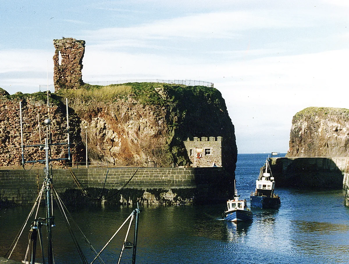
Dunbar Harbour is a seaport forming the north-east part of the town of Dunbar, East Lothian, Scotland. It is situated on a point projecting from the North Sea coast of East Lothian into the mouth of the Firth of Forth. The built harbour, on the site of an earlier natural anchorage, comprises three main sections: the Old Harbour, in the east of the port, protected by a sea-wall to its east and north and dating from the late 16th-Century; the New or Victoria Harbour in the west dating from 1842; and Broad Haven, formerly the approach from the Forth to the Old Harbour, but latterly, its entrance having been blocked, providing additional sheltered water between the Old and New Harbours. The harbour is a trust port, responsibility for which lies since 2004 with the Dunbar Harbour Trust. In prior times the port was controlled by the local authority and, earlier, by the magistrates and council of the burgh. It is the home port for a commercial fishing fleet, offering moorings and fuel and water facilities for pleasure yachts. It is the base for local sailing, rowing and diving clubs, as well as for the RNLI lifeboat station.
Excerpt from Wikipedia under CC BY-SA 4.0. See the source article linked in Sources below.
Background
Architecture
Dunbar Lifeboat Station, constructed in 1901 and continuing a service dating from 1808. The port complex has a number of notable structures: on Lamar Island, a fort with a battery of 16 guns was constructed from 1781 to guard against invasion and privateers; armaments were removed some time after the conclusion of the Peninsular War in 1814. The fort's structures were thereafter little used until 1874 when a hospital for infectious diseases was established pursuant to the Public Health (Scotland) Act 1867 (30 & 31 Vict. c. 101). This closed in 1905/6, although the premises were on occasion used as an overspill hospital. It was re-opened as a war hospital in 1914 and lasted through to…
Sourced from Wikipedia under CC BY-SA 4.0.
- Coordinates
- 56.0055, -2.5139
- District
- East Lothian
- Postcode
- EH42 1HY
- Parliamentary constituency
- Lothian East
- Phone
- 01368 865 899
- Nearest railway station
- Dunbar — 0.8 km
- Opening
- Wed – Sat: 10am – 5pm; Sun: 1pm – 5pm; Mon & Tue: Closed
- Official site
- www.jmbt.org.uk
Sources
- wikidata: Q104637678 (CC0)
- wikipedia: Dunbar Harbour (CC BY-SA 4.0)
Other places nearby

Dunbar Lifeboat Station
Harbours & ports · 0.1 km

Old Harbour, Dunbar
Marinas · 0.1 km
Dunbar Castle
Castles · 0.1 km

Fishermens' Monument, Old Harbour, Dunbar
Memorials & monuments · 0.2 km

The Fishermen's Monument
Memorials & monuments · 0.2 km

The Gunholes
Castles · 0.2 km

Dunbar, Castle Park
Vineyards · 0.3 km

The Magazine
Castles · 0.3 km

Lauderdale House, Victoria Street, Dunbar
Historic houses · 0.3 km

St Anne's Episcopal Church, Westgate, Dunbar
Historic churches · 0.3 km

John Muir Birthplace
Museums · 0.3 km
John Muir's Birthplace
Museums · 0.3 km
Nearby
📷 4Harbours & ports · Central Scotland
Dunbar Lifeboat Station
Dunbar Lifeboat Station in Scotland Islands, United Kingdom.
📷 5📷 3Castles · Central Scotland
Dunbar Castle
Dunbar Castle — castle in East Lothian, Scotland, UK.
📷 5Memorials & monuments · Central Scotland
Fishermens' Monument, Old Harbour, Dunbar
Fishermens' Monument, Old Harbour, Dunbar — category B listed building-listed memorial in scotland-central, United Kingdom.
📷 3Memorials & monuments · Central Scotland
The Fishermen's Monument
The Fishermen's Monument — a memorial in scotland-central, United Kingdom.
📷 3Castles · Central Scotland
The Gunholes
The Gunholes — a castle in scotland-central, United Kingdom.
Where to eat & stay near Dunbar Harbour
Places to stay
 📷 5
📷 5Hostels · Central Scotland
The Dolphin Inn
The Dolphin Inn — a hostel in scotland central.
📷 5Hostels · Central Scotland
The Dolphin Inn
The Dolphin Inn — a hostel in scotland central.
 📷 5
📷 5Caravan parks · Central Scotland
Belhaven Bay Caravan Site
Belhaven Bay Caravan Site — a caravan park in scotland central.
 📷 5
📷 5Caravan parks · Central Scotland
Dunbar Camping and Caravanning Club Site
Dunbar Camping and Caravanning Club Site — a caravan park in scotland central.
 📷 5
📷 5Caravan parks · Central Scotland
Thurston Manor Caravan Park
Thurston Manor Caravan Park — a caravan park in scotland central.
 📷 5
📷 5Places to eat & drink
 📷 5
📷 5Historic pubs · Central Scotland
The Crown & Kitchen
The Crown & Kitchen in Scotland Central, United Kingdom.
 📷 5
📷 5Historic pubs · Central Scotland
Gardner's Arms Public House, Market Street, Haddington
Gardner's Arms Public House, Market Street, Haddington in Scotland Central, United Kingdom.
More places in this region
 📷 5
📷 5 Flagship📷 4
Harbours & ports · Central Scotland
Port Glasgow
Port Glasgow — town in the Inverclyde council area of Scotland, UK.
 📷 3
📷 3Harbours & ports · Central Scotland
Largs harbour
Largs harbour — harbour at Largs, North Ayrshire, Scotland, UK.
 📷 3
📷 3Harbours & ports · Central Scotland
Millport Harbour
Millport Harbour — harbor at Millport, Great Cumbrae Island, North Ayrshire, Scotland, UK.
Frequently asked questions
- Where is Dunbar Harbour?
- Dunbar Harbour is in the Scottish Highlands, United Kingdom (postcode EH42 1HY).
- What is Dunbar Harbour?
- Dunbar Harbour in Scotland Islands, United Kingdom.
- How do I get to Dunbar Harbour?
- The nearest railway station is Dunbar, about 0.8 km away. Drivers can use postcode EH42 1HY.
- How do I get to Dunbar Harbour?
- The nearest railway station is Dunbar, about 0.8 km away. Drivers can navigate to postcode EH42 1HY.