Mountains & hills · Scottish Islands
Druim na Buainn
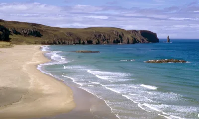
Druim na Buainn — mountain in scotland islands. Elevation: 153 m.

Richard Webb — CC BY-SA 2.0 via Wikimedia Commons licence
Plan your visit
- Typical visit
- 3 h–8 h
- Best time of year
- Late spring – early autumn (May–Oct)
About
Druim na Buainn is a mountain located in scotland islands. Elevation: 153 m. A named British peak recorded in OpenStreetMap. Peaks are typically named on Ordnance Survey 1:50k mapping.
Photo gallery
Place summary
Druim na Buainn is a mountain located in the Scottish Islands. It is characterised by its rugged terrain and scenic views typical of the region. The mountain offers opportunities for walking and outdoor activities, attracting those interested in exploring the natural landscape of Scotland.
AI-generated from the structured facts on this page (operator, designation, listing, era). Not a substitute for visiting.
- Coordinates
- 58.5292, -5.0712
Sources
- osm: n603249814 (ODbL)
Other places nearby
Loading nearby places…
Nearby
📷 5Mountains & hills · Scottish Islands
Druim na Buainn
Druim na Buainn — a hill or mountain in scotland islands.
 📷 3
📷 3Historic houses · Scottish Islands
Fishermen's Bothy
Fishermen's Bothy — a historic house in scotland-islands, United Kingdom.
 📷 5
📷 5Mountains & hills · Scottish Islands
Càrn an Rìgh
Càrn an Rìgh — mountain in scotland islands. Elevation: 133 m.
 📷 3
📷 3Mountains & hills · Scottish Islands
Sandwood Bay
Sandwood Bay — bay in Highland, Scotland, UK.
 📷 5
📷 5Villages · Scottish Islands
Sandwood
Sandwood — a village in scotland islands.
 📷 3
📷 3Islands · Scottish Islands
Am Buachaille
Am Buachaille — island in Highland, Scotland, UK.
Where to eat & stay near Druim na Buainn
Places to stay
 📷 5
📷 5Campsites · Scottish Highlands
Old docks
Old docks — a campsite in scotland highlands.
 📷 5
📷 5Caravan parks · Scottish Islands
Balnakeil Motorhome Stopover
Balnakeil Motorhome Stopover — a caravan park in scotland islands.
 📷 5
📷 5Hostels · Scottish Islands
Lazy Crofter Bunkhouse/Hostel
Lazy Crofter Bunkhouse/Hostel — a hostel in scotland islands.
📷 5Hostels · Scottish Islands
Lazy Crofter
Lazy Crofter — a hostel in scotland islands.
 📷 5
📷 5Campsites · Scottish Islands
Sango Sands
Sango Sands — a campsite in scotland islands.
 📷 5
📷 5Campsites · Scottish Highlands
Scourie Caravan and Campsite
Scourie Caravan and Campsite — a campsite in scotland highlands.
More mountains in this region
 📷 3
📷 3Mountains & hills · Scottish Islands
Aikerness Bay
Aikerness Bay — bay in Orkney Islands, Scotland, UK.
 📷 3
📷 3Mountains & hills · Scottish Islands
Aith Hope
Aith Hope — bay in Orkney Islands, Scotland, UK.

Mountains & hills · Scottish Islands
Aith Voe
Aith Voe — bay on West Mainland, Shetland Islands, Scotland, UK.
 📷 3
📷 3Mountains & hills · Scottish Islands
Aith Voe
Aith Voe — bay on South Mainland, Shetland Islands, Scotland, UK.
Frequently asked questions
- Where is Druim na Buainn?
- Druim na Buainn is in the Scottish Islands, United Kingdom.
- What is Druim na Buainn?
- Druim na Buainn — mountain in scotland islands. Elevation: 153 m.
- How do I get to Druim na Buainn?
- Its coordinates are 58.5292°, -5.0712°.