
Natural landmarks · Scottish Highlands
Creag Meagaidh
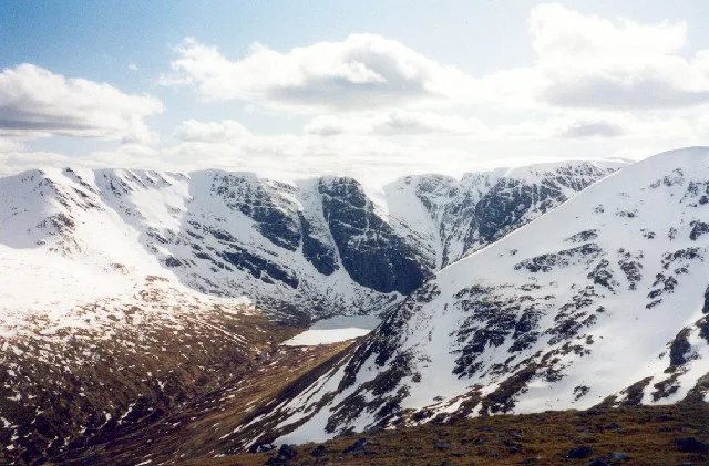
Creag Meagaidh — 1128m high mountain in Highland, Scotland, UK.

Wikimedia Commons contributors — see linked file page for photographer and licence licence

Plan your visit
- Typical visit
- 1 h–2 h
- Nearest railway station
- Tulloch · 9.7 km
- Free entry
- Dog-friendly
Getting there & planning your visit
To visit Creag Meagaidh in the Scottish Highlands, the nearest railway station is Tulloch, located 9.7 km away. Entry to the site is free. The location is remote with no specific postcode provided.
About
Creag Meagaidh is a named natural landmark in the United Kingdom. Heritage designation: Site of Special Scientific Interest. Wikidata describes it as: "1128m high mountain in Highland, Scotland, UK". Coordinates: 56.9520°, -4.6021°.
Photo gallery
Official information
Creag Meagaidh is a prominent mountain in the central Highlands, known for its distinctive cleft called the Window. It features a vast plateau and is particularly famous among ice-climbers for the impressive Coire Àrdair, which is a popular climbing destination.
From the Wikipedia article
Creag Meagaidh (Scottish Gaelic: Creag Mèagaidh) is a mountain on the northern side of Glen Spean in the Highlands of Scotland. It is a complex mountain, made up of a flat summit plateau, with five ridges spreading out from it, overlooking five deep corries; it is most famed for the cliffs surrounding the corrie of Coire Ardair on the north-eastern face. These crags are a renowned venue for ice climbing. Creag Meagaidh rises to 1,130 metres (3,710 ft). The neighbouring peaks of Stob Poite Coire Ardair and Càrn Liath are sometimes called the Creag Meagaidh range. The Creag Meagaidh massif is part of Creag Meagaidh National Nature Reserve. The reserve covers 3,940 hectares, extending from the shores of Loch Laggan to the high summit plateau of Creag Meagaidh. The reserve was designated in 1986 and is owned and managed by NatureScot. Creag Meagaidh is also designated as a Special Protection Area, and the number of grazing animals is controlled. This has led to a regrowth of the native woodland of birch, alder, willow, rowan and oak. The site is also an important breeding ground for many species of birds, in particular the dotterel.
Excerpt from Wikipedia under CC BY-SA 4.0. See the source article linked in Sources below.
Background
History
The earliest historical records for Creag Meagaidh are from the seventeenth and early eighteenth centuries, when the area was farmed by tenants who grew crops on the lower slopes and grazed cattle on the higher ground during the summer. Following the Jacobite rising of 1745 the then owner, Ewen MacPherson of Cluny, was deprived of his estate, which was then managed on behalf of the Crown by the Commissioners for Forfeited Estates. The commission began the process of evicting the tenants and consolidating the holdings into a single sheep farm, and by 1790 there were around 20,000 sheep in the parish of Laggan. In 1784 Creag Meagaidh was restored to the Macpherson family. The first recorded…
Sourced from Wikipedia under CC BY-SA 4.0.
- Coordinates
- 56.9520, -4.6021
- Address
- Glen Spean, Scotland
- Nearest railway station
- Tulloch — 9.7 km
- Official site
- www.walkhighlands.co.uk
Sources
- wikidata: Q3397446 (CC0)
- wikipedia: Creag Meagaidh (CC BY-SA 4.0)
- commons: Coire Ardair.jpg (CC BY-SA 4.0)
Other places nearby
Creag Mèagaidh
Mountains & hills · 0.0 km

Creag Meagaidh East Top
Mountains & hills · 0.6 km

Stob Poite Coire Ardair
Mountains & hills · 1.8 km

Loch Roy
Lakes · 1.8 km

Puist Coire Ardair
Mountains & hills · 1.9 km

Creag Meagaidh - Puist Coire Ardair
Mountains & hills · 1.9 km

Creag Meagaidh - Meall Coire Choille-rais
Mountains & hills · 1.9 km

Meall Coire Choille-rais
Mountains & hills · 1.9 km

Lochan a’ Choire
Lakes · 2.0 km

Carn Dearg
Mountains & hills · 2.1 km

Creag Meagaidh - An Cearcallach
Mountains & hills · 2.3 km

Stob Poite Coire Ardair East Top
Mountains & hills · 2.5 km
Nearby
📷 5Mountains & hills · Scottish Highlands
Creag Mèagaidh
Creag Mèagaidh — Named summit at 1128 m.
📷 3Mountains & hills · Scottish Highlands
Creag Meagaidh East Top
Creag Meagaidh East Top — a mountain in scotland-highlands, United Kingdom.
📷 3Mountains & hills · Scottish Highlands
Stob Poite Coire Ardair
Stob Poite Coire Ardair — Named summit at 1054 m.
📷 5📷 5Mountains & hills · Scottish Highlands
Puist Coire Ardair
Puist Coire Ardair — a hill or mountain in scotland highlands.
📷 3Mountains & hills · Scottish Highlands
Creag Meagaidh - Puist Coire Ardair
Creag Meagaidh - Puist Coire Ardair — a mountain in scotland-highlands, United Kingdom.
Where to eat & stay near Creag Meagaidh
Places to stay
 📷 5
📷 5 📷 5
📷 5Hostels · Scottish Highlands
Great Glen Hostel
Great Glen Hostel — a hostel in scotland highlands.
 📷 5
📷 5Campsites · Scottish Highlands
Laggan Locks informal campsite
Laggan Locks informal campsite — a campsite in scotland highlands.
 📷 5
📷 5Campsites · Scottish Highlands
Bunroy Caravan & Camping Park
Bunroy Caravan & Camping Park — a campsite in scotland highlands.
 📷 5
📷 5 📷 5
📷 5Campsites · Scottish Highlands
Leitirfearn Trailblazer Rest
Leitirfearn Trailblazer Rest — a campsite in scotland highlands.
Places to eat & drink
 📷 5
📷 5Historic pubs · Scottish Highlands
The Lovat Hotel
The Lovat Hotel in Scotland Highlands, United Kingdom.
More natural landmarks in this region
 Flagship📷 3
Natural landmarks · Scottish Highlands
Dunalastair Water
Dunalastair Water — lake in Perth and Kinross, Scotland, UK, on the River Tummel.
 Flagship📷 3
Natural landmarks · Scottish Highlands
Loch Arkaig
Loch Arkaig — lake in Highland, Scotland, UK, outflows east to River Arkaig.
 Flagship📷 3
Natural landmarks · Scottish Highlands
Loch Assynt
Loch Assynt — lake in Highland, Scotland, UK, outflows to the River Inver and Loch na Garbh Uidhe.
 Flagship📷 5
Natural landmarks · Scottish Highlands
Loch Eilt
Loch Eilt — lake in Highland, Scotland, UK, outflows west to River Ailort.
Frequently asked questions
- Where is Creag Meagaidh?
- Creag Meagaidh is in the Scottish Highlands, United Kingdom.
- What is Creag Meagaidh?
- Creag Meagaidh — 1128m high mountain in Highland, Scotland, UK.
- How do I get to Creag Meagaidh?
- The nearest railway station is Tulloch, about 9.7 km away. Its coordinates are 56.9520°, -4.6021°.
- Is Creag Meagaidh a listed building?
- Creag Meagaidh is officially recognised as Site of Special Scientific Interest listed.
- Is Creag Meagaidh free to visit?
- Yes, Creag Meagaidh is free to enter.