Historic churches · South West England
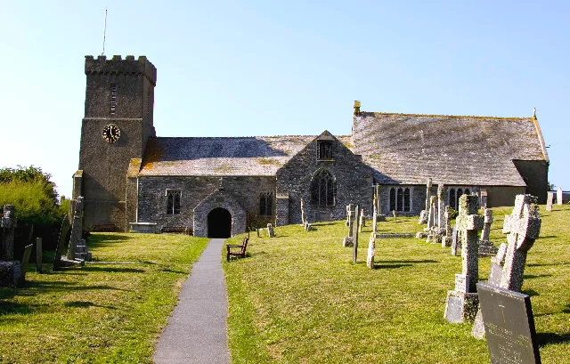
Crantock
In or near Perranporth.
Crantock (Cornish: Lanngorrow) is a coastal civil parish and village in Cornwall, England, two miles (3 km) southwest of Newquay. In 460, a group of Celtic missionaries founded an oratory there. The v

Ben Chmark — CC BY-SA 2.0 via Wikimedia Commons licence
Plan your visit
- Typical visit
- 30 min–1 h
- Nearest railway station
- Newquay · 2.9 km
- Free entry
Getting there & planning your visit
Crantock is located in Cornwall, with the postcode TR8 5SB. The nearest railway station is Newquay, which is 2.9 km away. Entry to the church is free.
About
Crantock (Cornish: Lanngorrow) is a coastal civil parish and village in Cornwall, England, two miles (3 km) southwest of Newquay. In 460, a group of Celtic missionaries founded an oratory there. The village lies to the south of the River Gannel, which forms the boundary between the parishes of Newquay and Crantock. The River Gannel is tidal and ferries operate on a seasonal basis from Fern Pit to Crantock Beach. The River Gannel runs along Crantock Beach and joins the Celtic Sea. The village can be reached from the A3075 road via the junction at Trevemper. The hamlets of Treninnick and West Pentire are in the parish. Large parts of the parish are now in the ownership of the National Trust, including West Pentire headland which is a Site of Special Scientific Interest noted for its wild flowers and rare plants.
Photo gallery
Official information
Crantock is a historic village in Cornwall, known for its rich history dating back to 460AD and its beautiful natural surroundings. Visitors can explore the village's conservation area, enjoy local pubs, churches, and cafes, and appreciate the rare plant species at West Pentire Headland, a Site of Special Scientific Interest.
Protected designations
- Area of Outstanding Natural Beauty: Cornwall
Designations sourced from Natural England open data under OGL v3.
From the Wikipedia article
Crantock (Cornish: Lanngorrow) is a coastal civil parish and village in Cornwall, England, two miles (3 km) southwest of Newquay. In 460, a group of Celtic missionaries founded an oratory there. The village lies to the south of the River Gannel, which forms the boundary between the parishes of Newquay and Crantock. The River Gannel is tidal and ferries operate on a seasonal basis from Fern Pit to Crantock Beach. The River Gannel runs along Crantock Beach and joins the Celtic Sea. The village can be reached from the A3075 road via the junction at Trevemper. The hamlets of Treninnick and West Pentire are in the parish. Large parts of the parish are now in the ownership of the National Trust, including West Pentire headland which is a Site of Special Scientific Interest noted for its wild flowers and rare plants.
Excerpt from Wikipedia under CC BY-SA 4.0. See the source article linked in Sources below.
Background
History
The Gannel Estuary, Cornwall: Archaeological and Historical Assessment, published by the Cornwall Archaeological Unit concluded that human activity around the Gannel could be dated to the Mesolithic period. The earliest development in the area is Treringey Round, a roughly-rectangular area enclosed by bank 1 metre high and an outer ditch 1.3 metres deep. It is of unknown pre-historic date. Treringey Round is located at the end of an ancient route at the head of the (then) navigable Gannel estuary. The older part of Crantock village is situated around its church which is dedicated to St Carantoc, founder of the village. At one time the parish was known as Langurroc which translates as – The…
Sourced from Wikipedia under CC BY-SA 4.0.
- Coordinates
- 50.4010, -5.1110
- District
- Cornwall
- Parish
- Crantock
- Postcode
- TR8 5SB
- Parliamentary constituency
- Truro and Falmouth
- Nearest railway station
- Newquay — 2.9 km
- Official site
- www.parish-council.com
Sources
- wikipedia: Crantock (CC BY-SA 4.0)
Other places nearby
St Carantoc's Church, Crantock
Historic churches · 0.2 km

Quarryfield Campsite
Campsites · 0.4 km

Quarryfields/Crantock Beach
Caravan parks · 0.5 km

Treago Farm
Campsites · 0.8 km
Higher Moor Camp Site
Campsites · 1.0 km

Crantock Beach
Beaches · 1.0 km
Three round cairns at The Warren on Pentire Point East
Archaeological sites · 1.3 km

The Gannel
Beaches · 1.3 km

Burial mound tumuli
Follies · 1.3 km
Porth Joke Camping Site
Campsites · 1.4 km

Crantock Monastery
Abbeys & priories · 1.4 km

River Gannel
Museums · 1.4 km
Nearby
📷 5Historic churches · South West England
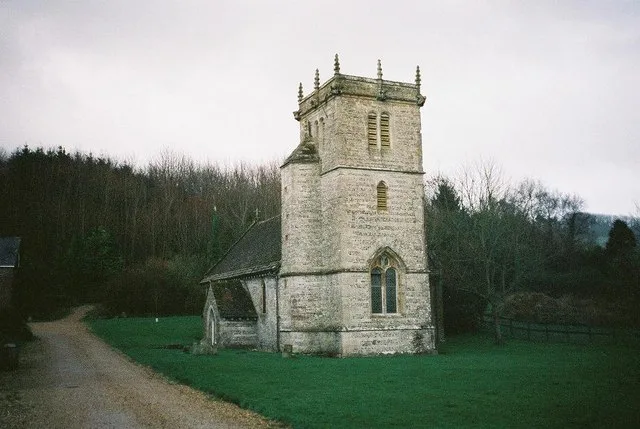
St Carantoc's Church, Crantock
St Carantoc's Church, Crantock — church in Cornwall, England, UK.
📷 5Campsites · South West England
Quarryfield Campsite
Quarryfield Campsite — a campsite in england south west.
📷 5Caravan parks · South West England
Quarryfields/Crantock Beach
Quarryfields/Crantock Beach — a caravan park in england south west. Brand: Parkdean Resorts.
📷 5📷 5Campsites · South West England
Higher Moor Camp Site
Higher Moor Camp Site — a campsite in england south west.
📷 5Where to eat & stay near Crantock
Places to stay
📷 5Campsites · South West England
Quarryfield Campsite
Quarryfield Campsite — a campsite in england south west.
📷 5Caravan parks · South West England
Quarryfields/Crantock Beach
Quarryfields/Crantock Beach — a caravan park in england south west. Brand: Parkdean Resorts.
📷 5📷 5Campsites · South West England
Higher Moor Camp Site
Higher Moor Camp Site — a campsite in england south west.
📷 5Campsites · South West England
Porth Joke Camping Site
Porth Joke Camping Site — a campsite in england south west.
 📷 5
📷 5Caravan parks · South West England
Trevella Caravan Park
Trevella Caravan Park — a caravan park in england south west.
Places to eat & drink
 📷 5
📷 5Historic pubs · South West England
The Wig And Pen Public House And Attached Forecourt Walls And Railings
The Wig And Pen Public House And Attached Forecourt Walls And Railings in England South West, United Kingdom.
 📷 7
📷 7Historic pubs · South West England
Daniell Arms Public House
Daniell Arms Public House in England South West, United Kingdom.
 📷 6
📷 6Historic pubs · South West England
The Shipwrights
The Shipwrights in England South West, United Kingdom.
More places in this region
 📷 5
📷 5Historic churches · South West England
Abbey Church of St Gregory the Great, Downside Abbey
Abbey Church of St Gregory the Great, Downside Abbey — church in Stratton-on-the-Fosse, Somerset, England, UK.
 📷 5
📷 5Historic churches · South West England
All Saints Church
All Saints Church — Grade I listed church in Woolley, Somerset, England, UK.
 📷 5
📷 5Historic churches · South West England
All Saints Church, Hampreston
All Saints Church, Hampreston — church in Hampreston, Dorset, England, UK.
 📷 5
📷 5Historic churches · South West England
All Saints Church, Nether Cerne
All Saints Church, Nether Cerne — church in Nether Cerne, Dorset, England, UK.
Frequently asked questions
- Where is Crantock?
- Crantock is in South-West England, United Kingdom (postcode TR8 5SB), in the parish of Crantock.
- What is Crantock?
- Crantock (Cornish: Lanngorrow) is a coastal civil parish and village in Cornwall, England, two miles (3 km) southwest of Newquay. In 460, a group of Celtic missionaries founded an oratory there. The v
- How do I get to Crantock?
- The nearest railway station is Newquay, about 2.9 km away. Drivers can use postcode TR8 5SB.
- Is Crantock a protected site?
- Yes — Crantock is part of the Cornwall National Landscape (AONB).
- Is Crantock free to visit?
- Yes, Crantock is free to enter.
- How do I get to Crantock?
- The nearest railway station is Newquay, about 2.9 km away. Drivers can navigate to postcode TR8 5SB.