
Towns & cities · West Midlands
Colton
Colton — village and civil parish in Lichfield District, Staffordshire, England.

Wikimedia Commons contributors — see linked file page for photographer and licence licence

Plan your visit
- Typical visit
- 3 h–6 h
- Nearest railway station
- Rugeley Trent Valley · 1.2 km
- Free entry
- Family-friendly
- Dog-friendly
Getting there & planning your visit
To visit Colton in the East Midlands, the nearest railway station is Rugeley Trent Valley, located 1.2 km away. Entry to the town is free.
About
Colton is a town, city, village or settlement in the United Kingdom. Recent population estimates put it at around 671 people. Address: WS15. Wikidata describes it as: "village and civil parish in Lichfield District, Staffordshire, England". Coordinates: 52.7800°, -1.9250°.
Photo gallery
Protected designations
- Area of Outstanding Natural Beauty: Cannock Chase
Designations sourced from Natural England open data under OGL v3.
From the Wikipedia article
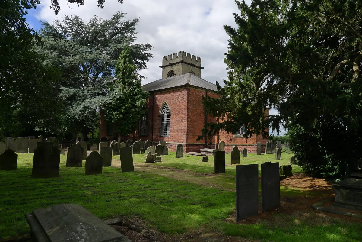
Colton is a village and civil parish in Lichfield District, Staffordshire, England. It is situated just outside the town of Rugeley off the B5013 road which heads towards Uttoxeter to the north. Colton is the home to Border Collie Trust GB, a registered charity rescuing and rehoming Border Collies and Collie crosses throughout the UK. The oldest building in the town is St Mary's Church, which dates back to the late 12th or early 13th century. The Colton Village Hall includes a playground park for young children and a small field popular with dog walkers. Beyond the field sits the Colton Wild Flower Meadow, which was established in 2018 to preserve meadow flowers, grasses, insect and bird life. The village is entered by way of a hump-back bridge over the Moreton Brook, which has a ford alongside for large vehicles. It is said that in World War II, a US army lorry took the bridge at speed and overturned, seriously injuring two soldiers. St. Mary's Church stands on the right, with St. Mary's School on the left. There used to be a pool on the left a short distance beyond the school, on which people would skate, or slide, during the frequent very cold winters of the 1960s. A hundred yards further on is the Forge, where the Williscroft family worked creating steel hoop for cart wheels, toboggans for use in the snow on The Martlin Hill. Colton House billeted a squad of Royal Engineers during the early years of World War II, and then American soldiers in 1944, with there being no telephone at Colton House, a soldier, with a bicycle, was permanently stationed a few hundred yards up the road outside the telephone box at the bottom of Martlin Lane, to respond as necessary when the telephone rang, in true Dad's Army fashion. The telephone service was part of the post office, and the soldier on duty at night would be comforted by a tray of cocoa and biscuits brought down the lane by the post-mistress's son. At the foot of Martlin Lane is the 'Pinfold'. Entering the Pinfold from…
Excerpt from Wikipedia under CC BY-SA 4.0. See the source article linked in Sources below.
- Coordinates
- 52.7800, -1.9250
- County
- Staffordshire
- District
- Lichfield
- Parish
- Colton
- Postcode
- WS15
- Parliamentary constituency
- Lichfield
- Population
- 671
- Nearest railway station
- Rugeley Trent Valley — 1.2 km
- Official site
- www.neighbourhood.statistics.gov.uk
Sources
- wikidata: Q1824737 (CC0)
- wikipedia: Colton, Staffordshire (CC BY-SA 4.0)
- commons: Heading into Colton from the Church - geograph.org.uk - 489757.jpg (CC BY-SA 4.0)
Other places nearby

Colton House
Historic houses · 0.3 km

Colton Mill Bridge
Historic bridges · 1.4 km

Loetitia B Litler
Memorials & monuments · 1.8 km
remains of old church of St Augustine
Historic houses · 1.8 km
Tomb of Elizabeth Cuting and Emma Hollinhurst
Memorials & monuments · 1.8 km

Rugeley Rose Theatre
Theatres · 2.0 km

Rugeley
Museums · 2.4 km

Viaduct over Trent and Mersey Canal at SK 0485 1780
Historic bridges · 2.4 km

Paving of the Town Centre 1984
Memorials & monuments · 2.5 km
Memorial to the Miners
Memorials & monuments · 2.5 km

The Deputy Miner
Public art & sculpture · 2.5 km
The Brereton Miner
Public art & sculpture · 2.5 km
Colton is a charming town in Staffordshire, located within the West Midlands region. Visitors can explore the historic Blithfield Hall or enjoy performances at the open-air Ridware Theatre. Nature lovers might also wish to visit the Wolseley Centre for a peaceful wildlife experience.
At a glance
- Population
- 671
- Administrative county
- Staffordshire
- Constituency
- Lichfield
Things to see in Colton
52 attractions within 12 km — showing the 24 most editorially-significant. Full guide: things to do in Colton →
 📷 3
📷 3Chapels · West Midlands
Armitage United Reform Church Chapel
Armitage United Reform Church Chapel — chapel in Armitage with Handsacre, Lichfield, Staffordshire, England, UK.
_-_geograph.org.uk_-_1441773.jpg?width=1200) 📷 3
📷 3Historic houses · West Midlands
Bishton Hall
Bishton Hall — country house in Staffordshire, England, UK.
 📷 3
📷 3Reservoirs & lochs · West Midlands
Blithfield Reservoir
Blithfield Reservoir — reservoir in the United Kingdom.
 📷 3
📷 3Historic houses · West Midlands
Church House
Church House — building in Abbots Bromley, Staffordshire, England, UK.
 📷 3
📷 3Historic churches · West Midlands
Church of St Leonard, Blithfield
Church of St Leonard, Blithfield — Grade I listed church, Blithfield, United Kingdom.
 📷 5
📷 5Historic churches · West Midlands
Church of St Nicholas, Mavesyn Ridware
Church of St Nicholas, Mavesyn Ridware — church in Mavesyn Ridware, Staffordshire, England, UK.
📷 3 📷 4
📷 4Viewpoints · West Midlands
Lower Cliff
Lower Cliff is a viewpoint in the United Kingdom.
 📷 3
📷 3Historic houses · West Midlands
Old Hall
Old Hall — house in Mavesyn Ridware, Staffordshire, England, UK.
📷 3Theatres · West Midlands
Rugeley Rose Theatre
Rugeley Rose Theatre is a theatre in the United Kingdom.
 📷 5
📷 5Historic pubs · West Midlands
The Goat's Head
The Goat's Head — Historic pub — listed building or notable heritage status.
 📷 3
📷 3Wildlife reserves · West Midlands
Wolseley Centre
Wolseley Centre — visitor centre in Staffordshire, UK.
 📷 3
📷 3Forests & woodlands · West Midlands
Wolseley Centre
Wolseley Centre is a forest or woodland in the United Kingdom.
 📷 3
📷 3Forests & woodlands · West Midlands
Birches Valley Forest Centre
Birches Valley Forest Centre — a other in england-east-midlands, United Kingdom.
 📷 3
📷 3Reservoirs & lochs · West Midlands
Blithfield Reservoir Walks
Blithfield Reservoir Walks — a other in england-east-midlands, United Kingdom.
📷 3Historic houses · West Midlands
remains of old church of St Augustine
remains of old church of St Augustine — a historic house in england-east-midlands, United Kingdom.
 📷 4
📷 4Historic houses · West Midlands
Blithfield Hall
Blithfield Hall — a Grade I-listed historic house in england-east-midlands, United Kingdom.
📷 3Historic bridges · West Midlands
Bridge, Gatepiers, Walls And Ha Ha South Of Blithfield Hall
Bridge, Gatepiers, Walls And Ha Ha South Of Blithfield Hall — Grade II listed building-listed bridge in england-east-midlands, United Kingdom.
📷 3Historic bridges · West Midlands
Viaduct over Trent and Mersey Canal at SK 0485 1780
Viaduct over Trent and Mersey Canal at SK 0485 1780 — Grade II listed building-listed bridge in england-east-midlands, United Kingdom.
 📷 3
📷 3Historic bridges · West Midlands
Bridge Number 64 off Armitage Road at SK 0537 1708
Bridge Number 64 off Armitage Road at SK 0537 1708 — Grade II listed building-listed bridge in england-east-midlands, United Kingdom.
 📷 3
📷 3Historic bridges · West Midlands
Wolseley Bridge Tea Rooms And Associated Buildings
Wolseley Bridge Tea Rooms And Associated Buildings — Grade II listed building-listed bridge in england-east-midlands, United Kingdom.
 📷 3
📷 3Historic bridges · West Midlands
Trent and Mersey Canal Bridge Number 59 at SK 0786 1642
Trent and Mersey Canal Bridge Number 59 at SK 0786 1642 — Grade II listed building-listed bridge in england-east-midlands, United Kingdom.
 📷 3
📷 3Historic bridges · West Midlands
Trent and Mersey Canal Bridge Number 60 at SK 079 164
Trent and Mersey Canal Bridge Number 60 at SK 079 164 — Grade II listed building-listed bridge in england-east-midlands, United Kingdom.
 📷 3
📷 3Historic bridges · West Midlands
Ornamental Bridge Over The Rising Brook, C.100M To The South-West Of Lakeside
Ornamental Bridge Over The Rising Brook, C.100M To The South-West Of Lakeside — Grade II listed building-listed bridge in england-east-midlands, United Kingdom.
Nearby
📷 3📷 3Historic bridges · West Midlands
Colton Mill Bridge
Colton Mill Bridge — Grade II listed building-listed bridge in england-east-midlands, United Kingdom.
📷 3Memorials & monuments · West Midlands
Loetitia B Litler
Loetitia B Litler — a memorial in england-east-midlands, United Kingdom.
📷 3Historic houses · West Midlands
remains of old church of St Augustine
remains of old church of St Augustine — a historic house in england-east-midlands, United Kingdom.
📷 3Memorials & monuments · West Midlands
Tomb of Elizabeth Cuting and Emma Hollinhurst
Tomb of Elizabeth Cuting and Emma Hollinhurst — a memorial in england-east-midlands, United Kingdom.
📷 3Theatres · West Midlands
Rugeley Rose Theatre
Rugeley Rose Theatre is a theatre in the United Kingdom.
Where to eat & stay near Colton
Places to stay
 📷 5
📷 5Caravan parks · West Midlands
Silvertrees Caravan Park
Silvertrees Caravan Park — a caravan park in england east midlands.
 📷 5
📷 5Caravan parks · West Midlands
Cannock Chase Camping and Caravanning Club
Cannock Chase Camping and Caravanning Club — a caravan park in england east midlands.
 📷 5
📷 5Caravan parks · West Midlands
Tackeroo Caravan Site
Tackeroo Caravan Site — a caravan park in england west midlands.
 📷 5
📷 5Caravan parks · West Midlands
Green Man Caravan Site
Green Man Caravan Site — a caravan park in england east midlands.
 📷 5
📷 5Campsites · West Midlands
Spring Slade Lodge
Spring Slade Lodge — a campsite in england west midlands.
 📷 5
📷 5Caravan parks · West Midlands
Kingfisher Holiday Park
Kingfisher Holiday Park — a caravan park in england east midlands.
Places to eat & drink
 📷 7📷 5
Historic pubs · West Midlands
The Goat's Head
The Goat's Head — Historic pub — listed building or notable heritage status.
 📷 7
📷 7 📷 5
📷 5Historic pubs · West Midlands
The Swan And Attached Buildings
The Swan And Attached Buildings in England West Midlands, United Kingdom.
 📷 5
📷 5 📷 5
📷 5Restaurants · West Midlands
Thai Rainbow
Thai Rainbow — a restaurant in england west midlands.
More towns in this region
 📷 3
📷 3Towns & cities · West Midlands
Hoar Cross
Hoar Cross — village in Staffordshire, England, UK.
 Flagship📷 3
 Flagship📷 3
 Flagship📷 5
Towns & cities · West Midlands
Ansty
Ansty — village and civil parish in Warwickshire, England, UK.
Frequently asked questions
- Where is Colton?
- Colton is in Staffordshire, the West Midlands, United Kingdom (postcode WS15), in the parish of Colton.
- What is Colton?
- Colton — village and civil parish in Lichfield District, Staffordshire, England.
- How do I get to Colton?
- The nearest railway station is Rugeley Trent Valley, about 1.2 km away. Drivers can use postcode WS15.
- Is Colton a protected site?
- Yes — Colton is part of the Cannock Chase National Landscape (AONB).
- Is Colton free to visit?
- Yes, Colton is free to enter.
- How do I get to Colton?
- The nearest railway station is Rugeley Trent Valley, about 1.2 km away. Drivers can navigate to postcode WS15.