
Mountains & hills · Scottish Highlands
Coire Gabhail
In or near Kinlochleven.
Coire Gabhail in Scotland Islands, United Kingdom.

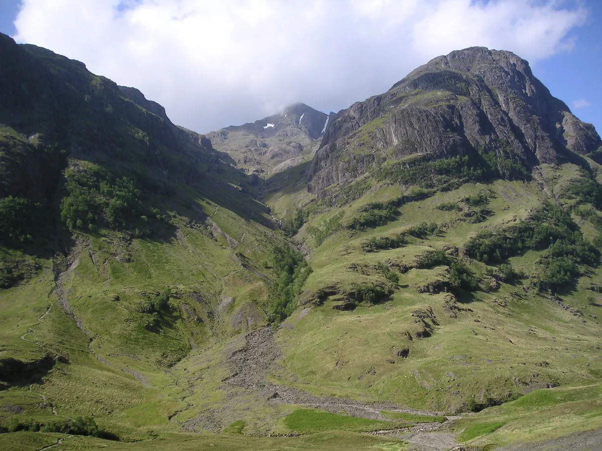
Jim Barton — CC BY-SA 2.0 via Wikimedia Commons licence

Plan your visit
- Typical visit
- 3 h–8 h
- Best time of year
- Late spring – early autumn (May–Oct)
- Free entry
- Dog-friendly
About
Coire Gabhail is a place of interest in Scotland Islands, United Kingdom — drawn from open-data sources for visitor reference. See the linked Wikipedia article for the full description.
Photo gallery
From the Wikipedia article
Coire Gabhail (Corrie of the Bounty, or The Hollow of Capture) is a high level glen in the Bidean nam Bian mountain massif to the south of Glen Coe, Highland, Scotland. Its narrow entrance 230 metres (750 ft) up the hillside conceals the width of the glen beyond, and it is commonly known as the Hidden Valley or Lost Valley of Glencoe. Access from a bridge crossing the River Coe is by a steep path up beside a narrow wooded ravine. Coire Gabhail runs southwestwards between the steeply-sided ridges of two of "The Three Sisters"; on its left, Beinn Fhada (Long Hill) is the eastmost sister, and the central sister Gearr Aonach (Short Ridge) on the right of the corrie forms its western side. Further to the west of Gearr Aonach, Coire nan Lochan is enclosed by Aonach Dubh (Black Ridge). The southern end of Coire Gabhail is marked by the peak of Stob Coire Sgreamhach on the ridge which then slopes down westwards to its low point at Bealach Dearg, then continues up above cliffs to the summit of Bidean nam Bian.
Excerpt from Wikipedia under CC BY-SA 4.0. See the source article linked in Sources below.
Background
History
to the left of centre.]] ridge on the other side of Glen Coe.]] This corrie was formed, like Glen Coe, by the movement of glaciers. The principal glacier in the glen below was larger and heavier, and carved out a deeper trough than that of Coire Gabhail. When the glaciers melted a hanging valley was left, high above the glen. Debris from the glaciers left moraines in the mouths of the glens and corries, often resulting in a lake forming behind them. In time these waters found their way through the debris and the lake drained leaving a relatively flat-bottomed alluvial plain which now forms the floor of the corrie. The name Coire Gabhail (Corrie of the Bounty, or The Hollow of Capture)…
Visiting
The path from Glen Coe up beside the gorge into Coire Gabhail is a popular short walk (around 3 km each way, ascent 230 m), the path is rough in places involving use of hands on rock for balance or as a step-up, and crossing a river by stepping stones. A car park on the south side of the A82 road, a short distance west of Allt-na-reigh cottage, has a path heading down eastwards to a footbridge across the River Coe. From here, rough stone steps lead up beside the ravine, with views of waterfalls. The top of the path leads out onto the shoulder formed by the ancient landslip, with views and a rough path to the flat corrie floor.
Sourced from Wikipedia under CC BY-SA 4.0.
- Coordinates
- 56.6544, -4.9940
Sources
- wikidata: Q20713463 (CC0)
- wikipedia: Coire Gabhail (CC BY-SA 4.0)
Other places nearby
Geàrr Aonach
Mountains & hills · 0.4 km

Beinn Fhada Far East Top
Mountains & hills · 0.5 km

Beinn Fhada
Mountains & hills · 0.6 km

Beinn Fhada East Top
Mountains & hills · 1.1 km

Beinn Fhada NE Top
Mountains & hills · 1.1 km

Meeting of Three Waters
Natural landmarks · 1.2 km

Beinn Fhada
Mountains & hills · 1.5 km
Beinn Fhada
Mountains & hills · 1.5 km

Royal Forest
Battlefields & battle sites · 1.5 km

Glen Coe
Natural landmarks · 1.6 km
Aonach Dubh
Mountains & hills · 1.6 km

Ossian's Cave
Caves · 1.7 km
Nearby
📷 3Mountains & hills · Scottish Highlands
Geàrr Aonach
Geàrr Aonach — a mountain in scotland-highlands, United Kingdom.
📷 3Mountains & hills · Scottish Highlands
Beinn Fhada Far East Top
Beinn Fhada Far East Top — a mountain in scotland-highlands, United Kingdom.
📷 5Mountains & hills · Scottish Highlands
Beinn Fhada
Beinn Fhada — mountain in scotland highlands. Elevation: 811 m.
📷 5Mountains & hills · Scottish Highlands
Beinn Fhada East Top
Beinn Fhada East Top — a hill or mountain in scotland highlands.
📷 3Mountains & hills · Scottish Highlands
Beinn Fhada NE Top
Beinn Fhada NE Top — a mountain in scotland-highlands, United Kingdom.
📷 4Natural landmarks · Scottish Highlands
Meeting of Three Waters
Meeting of Three Waters in Scotland Islands, United Kingdom.
Where to eat & stay near Coire Gabhail
Places to stay
 📷 5
📷 5Campsites · Scottish Highlands
Red Squirrel Campsite
Red Squirrel Campsite — a campsite in scotland highlands.
📷 5Hostels · Scottish Highlands
Glencoe Youth Hostel
Glencoe Youth Hostel — a hostel in scotland highlands.
 📷 5
📷 5Hostels · Scottish Highlands
Glencoe Independent Hostel
Glencoe Independent Hostel — a hostel in scotland highlands.
 📷 5
📷 5Campsites · Scottish Highlands
Glencoe Camping & Caravanning Club
Glencoe Camping & Caravanning Club — a campsite in scotland highlands.
 📷 5
📷 5Campsites · Scottish Highlands
Caolasnacon Caravan & Camping Park
Caolasnacon Caravan & Camping Park — a campsite in scotland highlands.
 📷 5
📷 5Hostels · Scottish Highlands
West Highland Lodge
West Highland Lodge — a hostel in scotland highlands.
Places to eat & drink
 📷 4
📷 4Historic pubs · Scottish Highlands
Clachaig Inn
Clachaig Inn in Scotland Islands, United Kingdom.
More mountains in this region
 📷 3
📷 3Mountains & hills · Scottish Highlands
A' Bhuidheanach Bheag
A' Bhuidheanach Bheag — Named summit at 936 m.
 📷 3
📷 3Mountains & hills · Scottish Highlands
A' Chailleach
A' Chailleach — Named summit at 997 m.
 📷 3
📷 3Mountains & hills · Scottish Highlands
A' Chailleach
A' Chailleach — Named summit at 930 m.
 📷 3
📷 3Frequently asked questions
- Where is Coire Gabhail?
- Coire Gabhail is in the Scottish Highlands, United Kingdom.
- What is Coire Gabhail?
- Coire Gabhail in Scotland Islands, United Kingdom.
- How do I get to Coire Gabhail?
- The nearest town is Kinlochleven. Its coordinates are 56.6544°, -4.9940°.
- Is Coire Gabhail free to visit?
- Yes, Coire Gabhail is free to enter.