
Villages · East Midlands
Claybrooke Parva
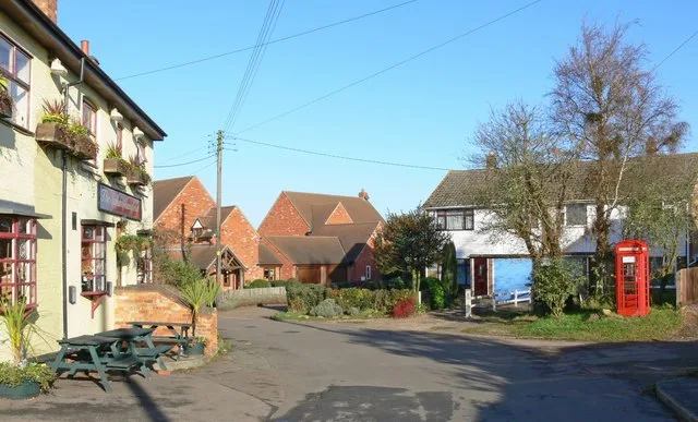
In or near Wibtoft.
Claybrooke Parva — a village in england west midlands.

Alan Murray-Rust — CC BY-SA 2.0 via Wikimedia Commons licence

Plan your visit
- Typical visit
- 1 h–2 h
- Nearest railway station
- Hinckley · 8.5 km
About
A British village — settlements of this size traditionally cluster a green, parish church, pub and post office around historic land routes.
Photo gallery
Place summary
Claybrooke Parva is a village located in the West Midlands. It is characterised by its rural setting and traditional English architecture. The village is part of the wider area known for its agricultural landscape and local community. Visitors can expect a quiet atmosphere typical of small British villages.
AI-generated from the structured facts on this page (operator, designation, listing, era). Not a substitute for visiting.
- Coordinates
- 52.4869, -1.2744
- County
- Leicestershire
- District
- Harborough
- Parish
- Claybrooke Parva
- Postcode
- LE17 5AF
- Parliamentary constituency
- South Leicestershire
- Nearest railway station
- Hinckley — 8.5 km
Sources
- manual: geonames-2652912 (CC BY 4.0)
Other places nearby

Claybrooke Parva War Memorial
Memorials & monuments · 0.2 km

Claybrooke Magna
Villages · 0.8 km

Ullesthorpe Mill
Historic houses · 1.2 km

Claybrooke Mill
Watermills · 1.3 km

Wibtoft
Villages · 1.4 km

Ullesthorpe
Villages · 1.5 km

Scout Camp
Campsites · 1.7 km

Wibtoft
Towns & cities · 1.8 km
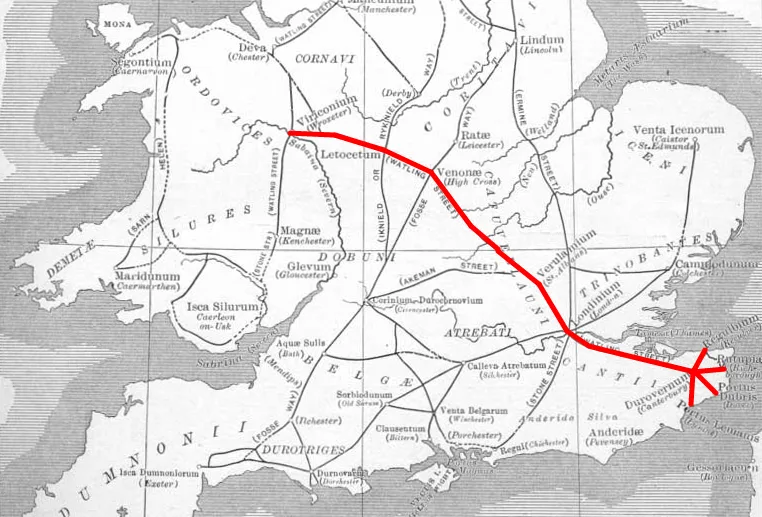
Venonis
Hill forts · 2.0 km

Venonae Roman Settlement
Archaeological sites · 2.2 km
Willey
Towns & cities · 3.1 km

Wigston Parva
Villages · 3.6 km
Nearby
📷 3Memorials & monuments · East Midlands
Claybrooke Parva War Memorial
Claybrooke Parva War Memorial — Grade II listed building-listed memorial in england-west-midlands, United Kingdom.
📷 5📷 4Historic houses · East Midlands
Ullesthorpe Mill
Ullesthorpe Mill — a Grade II*-listed historic house in england-west-midlands, United Kingdom.
📷 3Watermills · East Midlands
Claybrooke Mill
Claybrooke Mill is a watermill in the United Kingdom.
📷 5📷 5Where to eat & stay near Claybrooke Parva
Places to stay
📷 5 📷 4
📷 4Campsites · East Midlands
Fortway Farm
Fortway Farm — a campsite in england west midlands.
 📷 5
📷 5Campsites · West Midlands
Wolvey Villa Farm C. & C. Site
Wolvey Villa Farm C. & C. Site — a campsite in england west midlands.
 📷 5
📷 5Campsites · West Midlands
Makins Fishery Campsite
Makins Fishery Campsite — a campsite in england west midlands.
 📷 5
📷 5 📷 5
📷 5Hotels · West Midlands
Brownsover Hall Hotel
Brownsover Hall Hotel — a hotel in england west midlands.
Places to eat & drink
 📷 5
📷 5Historic pubs · East Midlands
The Olde Royal Oak Public House
The Olde Royal Oak Public House in England East Midlands, United Kingdom.
 📷 5
📷 5Historic pubs · East Midlands
The Cavalier Public House
The Cavalier Public House in England East Midlands, United Kingdom.
 📷 7
📷 7Historic pubs · East Midlands
The Greyhound Coaching Inn
The Greyhound Coaching Inn in England East Midlands, United Kingdom.
📷 7 📷 7
📷 7Historic pubs · East Midlands
Denbigh Arms Hotel
Denbigh Arms Hotel in England East Midlands, United Kingdom.
 📷 5
📷 5Historic pubs · East Midlands
Narborough Arms
Narborough Arms in England East Midlands, United Kingdom.
More places in this region
 📷 5
📷 5 📷 5
📷 5 📷 5
📷 5 📷 5
📷 5Frequently asked questions
- Where is Claybrooke Parva?
- Claybrooke Parva is in Leicestershire, the West Midlands, United Kingdom (postcode LE17 5AF), in the parish of Claybrooke Parva.
- What is Claybrooke Parva?
- Claybrooke Parva — a village in england west midlands.
- How do I get to Claybrooke Parva?
- The nearest railway station is Hinckley, about 8.5 km away. Drivers can use postcode LE17 5AF.
- How do I get to Claybrooke Parva?
- Drivers can navigate to postcode LE17 5AF. It sits within the South Leicestershire parliamentary constituency.