Country parks · North West England
Clarence Park
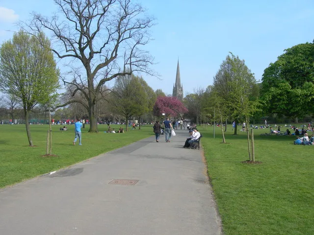
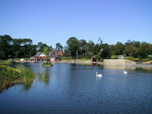
Clarence Park — urban park in Bury, Greater Manchester, England.

Wikimedia Commons contributors — see linked file page for photographer and licence licence
Plan your visit
- Typical visit
- 1.5 h–3 h
- Nearest railway station
- Burrs Country Park Halt · 1.2 km
- Free entry
- Family-friendly
- Dog-friendly
About
Clarence Park is a country park in the United Kingdom. Records date its origin to 1888. Managed by Bury Metropolitan Borough Council. Wikidata describes it as: "urban park in Bury, Greater Manchester, England". Coordinates: 53.6060°, -2.2870°.
Photo gallery
From the Wikipedia article
Clarence Park is a Green Flag awarded public park located in Bury, Greater Manchester. It is the largest urban park in the borough, and was opened to the public in 1888. The park's facilities include a bandstand, a skate park, tennis courts, a children's play area, a skate park, bowling green, a football pitch and a café. A lido with parking facilities offers angling opportunities and is home to a model boat club. Originally a reservoir, it was opened to the public in 1963.
Excerpt from Wikipedia under CC BY-SA 4.0. See the source article linked in Sources below.
- Coordinates
- 53.6060, -2.2870
- District
- Bury
- Parish
- Bury, unparished area
- Postcode
- BL9 6NF
- Parliamentary constituency
- Bury North
- Established
- 1888
- Nearest railway station
- Burrs Country Park Halt — 1.2 km
- Opening
- | website =
Sources
- wikidata: Q60743451 (CC0)
- wikipedia: Clarence Park, Bury (CC BY-SA 4.0)
- commons: Clarence Park - geograph.org.uk - 1751833.jpg (CC BY-SA 4.0)
Other places nearby
Loading nearby places…
Nearby
 📷 3
📷 3Public art & sculpture · North West England
Locomotive "Bury"
Locomotive "Bury" — a public art in england-north-west, United Kingdom.
 📷 4
📷 4Historic churches · North West England
St Paul's Church, Bury
St Paul's Church, Bury — Grade II listed building-listed church in england-north-west, United Kingdom.
 📷 3
📷 3Parks · North West England
Burrs Country Park
Burrs Country Park — park in United Kingdom.
 📷 5
📷 5Theatres · North West England
Vue Bury the Rock
Vue Bury the Rock — a cinema heritage in england-north-west, United Kingdom.
Cinemas · North West England
Vue
Vue — a cinema in england north west.
Campsites · North West England
Burrs Country Park Caravan Club
Burrs Country Park Caravan Club — a campsite in england north west.
Other places from this era
 Flagship📷 10
Country parks · London
Clissold Park
Clissold Park — park in Stoke Newington, London.
 📷 10
📷 10Country parks · London
Waterlow Park
Waterlow Park — park in Highgate, London.
 📷 5
📷 5Country parks · London
Victoria Park
Victoria Park — urban park majority in the London Borough of Tower Hamlets and small part in Hackney, England.
 Flagship📷 10
Country parks · South East England
Forbury Gardens
Forbury Gardens — park in Reading, Berkshire, England, UK.
More places in this region
 📷 4
📷 4Country parks · North West England
Alexandra Park
Alexandra Park — park in Oldham, Greater Manchester, England, UK.
 📷 5
📷 5Country parks · North West England
Heaton Park
Heaton Park — municipal park in Manchester, England.
 📷 4
📷 4Country parks · North West England
Queen's Park, Bolton
Queen's Park, Bolton — park in Bolton, Greater Manchester, England, UK.
 📷 3
📷 3Country parks · North West England
Ashton Gardens
Ashton Gardens — park in St Annes, Lancashire, England, UK.
Frequently asked questions
- Where is Clarence Park?
- Clarence Park is in North-West England, United Kingdom (postcode BL9 6NF), in the parish of Bury, unparished area.
- When was Clarence Park built?
- Built or established in 1888.
- Who owns Clarence Park?
- Clarence Park is owned by Bury Council and operated by Bury Metropolitan Borough Council.
- Is Clarence Park free to visit?
- Yes, Clarence Park is free to enter.
- How do I get to Clarence Park?
- The nearest railway station is Burrs Country Park Halt, about 1.2 km away. Drivers can navigate to postcode BL9 6NF.